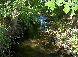
Leraubach
|
Leraubach Lerau; from the source to the confluence of the Fahrenberger Bach: Sautradlbach |
||
|
Leraubach near Kößlmühle |
||
| Data | ||
| Water code | DE : 14326 | |
| location |
Upper Palatinate Forest
|
|
| River system | Danube | |
| Drain over | Luhe (Naab) → Naab → Danube → Black Sea | |
| source | northwest of Weißenstein near Galgenholz 49 ° 38 ′ 1 ″ N , 12 ° 22 ′ 16 ″ E |
|
| Source height | approx. 607 m | |
| muzzle | west of Burgmühle in die Luhe Coordinates: 49 ° 36 '14 " N , 12 ° 14' 49" E 49 ° 36 '14 " N , 12 ° 14' 49" E |
|
| Mouth height | approx. 421 m | |
| Height difference | approx. 186 m | |
| Bottom slope | approx. 15 ‰ | |
| length | 12.8 km | |
| Catchment area | 27.14 km² | |
| Communities | Vohenstrauss , Leuchtenberg | |
The Leraubach is a 12.8 km long, left tributary of the Luhe in the Neustadt an der Waldnaab district in Upper Palatinate in Bavaria .
course
The Leraubach rises 2.5 km northeast of Vohenstrauß and 500 m northwest of Weißenstein im Galgenholz. From its source it turns to the west and after 250 m swings in a south-westerly direction. After 1.5 km it crosses the connecting road Vohenstrauss - Pleystein and flows 70 m on its southern side. Here it takes in water from the Tachetsbrunnen spring from the left. Then he goes back to the north side of the road. It now flows in a westerly direction along the northern outskirts of Vohenstrauss. He donates his water to the Vohenstrauss outdoor pool. 300 m after the outdoor swimming pool at Sägmühlweg, it takes up the Fahrenberger Bach coming from the north from the right. From its source to the confluence of the Fahrenberger Bach, the Leraubach bears the name Sautradlbach.
The Leraubach flows around Vohenstrauß on the northern edge of the village and resumes its south-westerly direction at Kößlmühle . It passes under the state road St 2166 . At Neumühle he turns south.
The Leraubach flows east past Neumühle, west past Arnmühle and east past Unterlind . There he turns back to the west. He leaves the Vohenstrauß community and moves to the Leuchtenberg community . Shortly before Lerau he takes the Steinachbach from the left . The Leraubach now flows around Lerau on the southern outskirts.
The Leraubach keeps its westerly direction. He crosses the hamlet of Sargmühle . Then he enters a deeply cut, narrow breakthrough valley at Wolfslohklamm. The Wolfslohklamm is a recognized geotope. In this area, the Leraubachtal is a designated nature reserve. The Poppenhofer Eicha is located on the northern side of the valley. The 585-meter-high Leuchtenberg with the Leuchtenberg castle ruins rises on its southern side .
At the end of the breakthrough valley, the Leraubach passes the Burgmühle and flows into the Luhe.
Tributaries
From the source to the mouth:
- the Fahrenberger Bach from the right on the northern outskirts of Vohenstrauss
- the Steinachbach from the left southeast of Lerau
Individual evidence
- ↑ a b c Course and catchment area of the Leraubach
- ↑ a b Length and catchment area according to: Directory of creek and river areas in Bavaria - Naab river area, page 70 of the Bavarian State Office for the Environment, as of 2016 (PDF; 4.0 MB)
- ↑ https://www.umweltatlas.bayern.de/mapapps/resources/reports/geotope/generateBericht.pdf?additionallayerfieldvalue=374R030
- ↑ http://www.regierung.oberpfalz.bayern.de/leistungen/umwelt/info/naturschutzgebiete/nsg_new/ Leuchtenberg/ 004_info.htm
