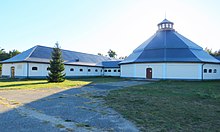
Leszno-Julinek
| Leszno | ||
|---|---|---|

|
|
|
| Basic data | ||
| State : | Poland | |
| Voivodeship : | Mazovia | |
| Powiat : | Warszawski Zachodni | |
| Gmina : | Leszno | |
| Geographic location : | 52 ° 15 ' N , 20 ° 35' E | |
| Residents : | 3780 (2010) | |
| Postal code : | 05-084 | |
| Telephone code : | (+48) 22 | |
| License plate : | WZ | |
| Economy and Transport | ||
| Street : | DW579 Kazuń Polski– Grodzisk Mazowiecki | |
| Rail route : | DW580 Sochaczew - Warsaw | |
| Next international airport : | Warsaw | |
| Administration (as of 2018) | ||
| Wójt : | Grzegorz Banaszkiewicz | |
| Address: | ul.Wojska Polskiego 21 05-084 Leszno |
|
| Website : | www.gminaleszno.pl | |
Leszno-Julinek is a Schulzenamt ( Polish sołectwo) of the rural municipality Leszno in the Powiat Warszawski Zachodni (Warsaw West) of the Masovian Voivodeship in Poland . It consists of Leszno and Julinek.
Leszno with about 3750 inhabitants is the seat of the rural municipality with 10,193 inhabitants (as of June 30, 2019). Julinek has about 40 residents and is known for the State School of Circus Arts .
geography
The places are about 25 kilometers west of Warsaw . The north of the municipality belongs to the wooded Kampinos National Park (Kampinoski Park Narodowy). Leszno is located in the south of the municipality and borders in the west on Rochale (Wielkie), Walentów, Grądki, Grądy and Marianów, in the north on the Julinek settlement, which in turn borders on Kępiaste in the north, and in the east like Julinek on Zaborówek and Białutki , to the south at Radzików, Białuty and Rochaliki. The last four localities belong to the neighboring town-and-country municipality of Błonie .
local community
In addition to Leszno and Julinek, the rural community (gmina wiejska) Leszno includes a number of other localities that are grouped into 25 school offices. The community has an area of 125 km².
Economy and Infrastructure
The State School of Circus Art (Państwowa Szkoła Sztuki Cyrkowej) has been located in Julinek since 1967 ; its headquarters were temporarily moved to Warsaw. It used to employ up to 1,500 people.
traffic
The voivodship road DW579 runs through the two Ore and the municipality from north to south. It leads from Kazuń Polski in Gmina Czosnów to Grodzisk Mazowiecki in the south. Before that it reaches the junction of the A2 motorway ( E 30 ) after 13 kilometers . The voivodeship road DW580 leads from Sochaczew in the west via the main town of the neighboring municipality Kampinos and Leszno to Stare Babice and Warsaw.
The nearest train station is Błonie on the Warsaw – Posen – Berlin , which is served by local traffic in the voivodeship. - The nearest international airport is Warsaw Airport .
Web links

