
Lighthouse St. Mary's Light
| Lighthouse St. Mary's Light | ||
|---|---|---|
 |
||
| Place: | Mary's lamp | |
| Location: | Fehmarn Island | |
| Geographical location: | 54 ° 29 '41.9 " N , 11 ° 14' 17.6" E | |
| Fire carrier height : | 33.1 m | |
| Fire height : | 39.6 m | |
|
||
| Identifier : | Blz (4) wr -15 s | |
| Scope knows: | 17.7 nm (32.8 km ) | |
| Scope red: | 17.7 nm (32.8 km ) | |
| Optics: | rotatable lens light | |
| Operating mode: | electric, double Osram lamp TYPE HQJ - T 400 W / 230 V | |
| Function: | Cross-mark and orientation lights for shipping in the Fehmarnbelt | |
| Construction time: | 1964 | |
| Operating time: | since 1964 | |
| International ordinal number: | C 1284 | |

The lighthouse Marienleuchte serves as Quermarken- and leading light for shipping in Fehmarnbelt . It is located about 1.3 kilometers southeast of the Puttgarden ferry station in the northeast of the island of Fehmarn . The red and white striped reinforced concrete tower took over the functions of the neighboring clinker building from 1831/32 in 1964 .
The old tower

The Marienuchter lighthouse was built in 1831/32 and put into service on October 28, 1832. It replaced a fire beacon maintained at this point . The yellow- washed building made of red brick has a square, yellow brick tower. At the top there is a roof platform with a round lantern . The south side of the tower is decorated with the monogram of the Danish King Friedrich VI. It is named after Friedrich's wife, Queen Marie Sophie Friederike . It is unclear whether the couple was present for the inauguration. In addition to the optical signals, the tower also had an acoustic warning system ( fog horn ). From 1879 a compressed air siren and after 1930 an electric membrane transmitter served as a sound generator. The entire system was decommissioned in 1967. The lighthouse building is now a listed building . It is not open to the public and is becoming increasingly dilapidated.
The new tower

With the increasing traffic on the Vogelfluglinie and in the Fehmarnbelt , the old tower was no longer sufficient. In 1964 a new reinforced concrete tower was built about 160 meters north. To protect it against the weather, it was clad with red and white hard fiber cement panels. The beacon is equipped with a rotatable lens light and generates a light intensity of 722250 candela with a 400 watt lamp. This optic dates from 1875 and was taken from the old tower. The lighthouse has two red warning sectors ( Puttgardenriff and cross traffic over the Kiel-Ostsee-Weg ) and two white orientation sectors ; a diesel generator in the adjoining building ensures the emergency power supply. The Lübeck Waterways and Shipping Office is responsible for the maintenance and upkeep of the tower ; the fire is monitored and remotely controlled from the branch in Travemünde .
Others
On the site there is also a level measuring point from the Waterways and Shipping Office and an ODL probe for monitoring environmental radioactivity from the Federal Office for Radiation Protection . In the immediate vicinity of the lighthouse is the branch of the naval telecommunications station 722 - Marienuchter (Fehmarn) of the Bundeswehr .
See also
Other lighthouses on the island of Fehmarn:
gallery


South side of the old tower building
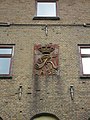
Monogram of the Danish King Friedrich VI.

View from the new tower to the old one.


Web link
Individual evidence
- ↑ Marien Leuchtturm lighthouse (old tower) at Leuchttuerme.net
- ↑ Marien Leuchtturm lighthouse at Deutsche Leuchtfeuer
- ↑ Marien Leuchtturm lighthouse (new tower) at Leuchttuerme.Net
- ↑ Page of the lighthouse at the water and shipping office Lübeck
- ↑ Water level sites of the WSV
- ↑ Data from the ODL measuring point Marienlicht