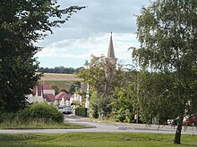
Liebing (municipality of Mannersdorf an der Rabnitz)
|
Liebing ( village ) locality |
||
|---|---|---|
|
|
||
| Basic data | ||
| Pole. District , state | Oberpullendorf (OP), Burgenland | |
| Judicial district | Oberpullendorf | |
| Pole. local community | Mannersdorf an der Rabnitz ( KG Rattersdorf-Liebing) | |
| Coordinates | 47 ° 24 '48 " N , 16 ° 29' 43" E | |
| height | 293 m above sea level A. | |
| Residents of the village | 222 (January 1, 2020) | |
| Building status | 123 (2001) | |
| Statistical identification | ||
| Locality code | 00200 | |
| Counting district / district | Liebing (10811 002) | |
| Source: STAT : index of places ; BEV : GEONAM ; GIS-Bgld | ||
Liebing is a village in the municipality of Mannersdorf an der Rabnitz in Burgenland in Austria . Liebing has 234 inhabitants who live in 107 buildings on an area of 797.13 hectares (as of 2001).
location
It's up to the Güns ; this continues to flow in Hungary under the Hungarian name Gyöngyös , immediately north of the national border. Oberpullendorf is located 10 km north of Liebing.
Attractions
- Catholic branch church hl. Leonhard
- Pilgrimage church of Mariae Birth and Visitation with former cemetery
- Lady Chapel on the cemetery wall
- Rectory
See also
Individual evidence
- ↑ Local directory Burgenland, Statistics Austria, Vienna 2004, p. 131. ( Page no longer available , search in web archives ) Info: The link was automatically marked as defective. Please check the link according to the instructions and then remove this notice.


