
Liechtensteinstrasse
| Liechtensteinstrasse | |
|---|---|
|
|
|
 |
|
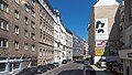
| Liechtensteinstrasse near Thurngasse, looking towards the city | |
| Basic data | |
| place | Vienna |
| District | Alsergrund |
| Created | before the 12th century |
| Hist. Names | Drey-Mohrengasse, Lange Gasse, Untere Hauptstrasse or Lichtentaler Hauptstrasse, on the Nussdorfer line |
| Name received | 1862 |
| Connecting roads | Southeast: Hohenstaufengasse; North: Liechtenwerder Platz and Heiligenstädter Straße |
| Cross streets | Maria-Theresien-Strasse, Kolingasse, Hörlgasse, Türkenstrasse, Berggasse, Thurngasse, Dietrichsteingasse, Harmoniegasse, Fürstengasse, Strudlhofgasse, Alserbachstrasse, Thurygasse, Fechtergasse, Bindergasse, Lichtentalergasse, Himmelpfortstiege, Reznicegasse, Latschaldkagiotstrasse, –Rufnicekgasse, Vereinsstiege, –Rufnicekgasse, Vereinsstiege |
| Places | Bauernfeldplatz, Ari-Rath-Platz |
| Buildings | Liechtenstein Garden Palace |
| use | |
| User groups | Pedestrians , cyclists , motorized private transport , bus route 40A |
| Technical specifications | |
| Street length | approx. 2040 m |
The Liechtenstein road is a local main street in the 9th Viennese district of Alsergrund .
history

In the area of today's Liechtensteinstrasse there was already a road to Klosterneuburg in the Middle Ages . This path was torn away by a heavy flood of the Danube in 1193; At that time, the steep drop north of Währinger Strasse was also created , which from this time took over the function of this traffic connection.
Liechtensteinstrasse ran between the suburbs of Alservorstadt and Roßau and connected Thurygrund , Himmelpfortgrund and Lichtental , where it ended at the Nussdorf line . From the Glacis to today's Bauernfeldplatz, the name has been Drey Mohren Gasse since 1771 , from Bauernfeldplatz to Alserbachstraße Lange Gasse (since 1796), to Viriotgasse Untere or Lichtenthaler Hauptstraße (since 1700) and in the last section to the line wall An der Nußdorfer Linie . After the suburbs were incorporated into Vienna, the entire street was named Liechtensteinstraße (after Prince Hans Adam I von und zu Liechtenstein , who had the Liechtenstein Garden Palace built on this street and founded the Lichtental suburb from 1699).
In June 1903 a tram line was opened from Kolingasse through Liechtensteinstrasse. The section between Alserbachstrasse and Newaldgasse was closed again in July 1922. The tram traffic in the section between Kolingasse and Alserbachstraße was replaced by a bus route in November 1960, and the route closed in September 1961. The remaining stretch between Newaldgasse and Liechtenwerder Platz was relocated in August 1983 to the Augasse, which ran parallel to it.
description
course
The Liechtenstein road starts at the border between the districts of Inner City and Alsergrund at the Maria Theresia Street in extending the Hohenstaufengasse and runs in first north-west, from the Alserbachstraße in an approximately north to the Liechtenwerder place where they are in the Heiligenstädterstraße continues . It is accompanied in the west by the striking slope of the Viennese city terrace , which is partly through steeply sloping cross streets (e.g. Kolingasse, Hörlgasse, Türkenstraße, Berggasse, Rufgasse, Viriotgasse, Latschkagasse), partly by several stairways (Thurnstiege, Strudlhofstiege , Bindergasse, Vereinsstiege) , Himmelpfortstiege) is overcome.
From Maria-Theresien-Strasse to Bauernfeldplatz, Liechtensteinstrasse is lined on both sides with shops from a wide variety of industries. Thereafter, shops are largely missing up to Alserbachstrasse. From Alserbachstraße to Althanstraße there are again mainly small shops, with gastronomic businesses making up a larger proportion.
Development
Several sections can be distinguished along the course of the street. The innermost section up to Berggasse, located in the area of the former Glacis, is characterized by representative five to six-storey apartment buildings from the 1870s. In the area up to Bauernfeldplatz, buildings from different periods can be found, from suburban houses from the Josephinism and Biedermeier periods to buildings from the various phases of historicism . This is followed by the area up to Alserbachstraße, which is characterized by the garden of the Palais Palais Clam-Gallas on the west side and the park of the Palais Liechtenstein, which extends on the east side of the street from Fürstengasse to Alserbachstraße. Along the west side of the street are bourgeois, partly also palais-like apartment buildings from the end of the 19th to the beginning of the 20th century. In the section between Alserbachstrasse and Liechtenwerderplatz, simpler suburban apartment buildings with five to six storeys dominate - in line with the increasing distance from the city center.
traffic
The Liechtenstein road provides a local connection from the ring road in the stock market for Alserbachstraße where branches direction Währing and Brigittenau made, and continue to Liechtenwerder Square and Heiligenstädterstraße direction Klosterneuburg . It is a main road A classified.
As a rule, only one lane per direction of travel is available for motor vehicle traffic. Between Thurngasse and Liechtenwerder Platz there are multi-purpose lanes ( cycle lanes which other vehicles may use under certain conditions and with special consideration for cyclists).
On public transport , bus line 40A runs the section from Maria-Theresien-Straße to Alserbachstraße. The tram lines 5 and 33 (Alserbachstraße) as well as 37 and 38 (Nussdorfer Straße) can be reached at the Nussdorfer Straße / Alserbachstraße stop, which is around 150 m away. Access to tram line D is at Liechtenwerder Platz, at the Augasse stop, which is also less than 100 m from Liechtensteinstrasse, and at Bauernfeldplatz.
An exit to the Schottentor underground station on the U2 line is just one block from the start of Liechtensteinstraße.
Notable addresses
(Listed objects are highlighted in bold.)
- No. 13: Friedrich Hebbel's house (memorial plaque)
- No. 19: (Identifying address: Berggasse 11) Strictly historical residential building
- No. 21: In the courtyard of the house there is a listed baroque figure of Maria Immaculata .
- No. 28: Josephinisches Bürgerhaus zur Holy Trinity (1781)
- No. 37: Studio Molière, formerly the Flieger-Kino
- No. 37A: Lycée Français de Vienne
- Fürstengasse 1: Liechtenstein Garden Palace
- Strudlhofgasse: Strudlhofstiege
- No. 51: Palais Szeps , today the Swedish Embassy
- No. 57: Historic rental house from 1875
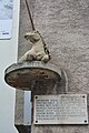
- opposite No. 69: Schubert fountain
- No. 74: Location of the house to the blue unicorn, which is mentioned several times in Heimito from Doderer's novel Die Strudlhofstiege
- in front of no.110: Prelate's Cross, in memory of the salvation from the explosion of the powder tower on June 26, 1779
- No. 132: Theater Experiment am Liechtenwerd
Picture gallery

At Türkenstrasse, looking out of town
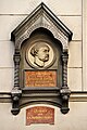
No. 13: Memorial plaque for Friedrich Hebbel
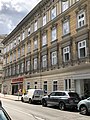
No. 19 (identical: Berggasse 11)
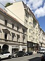
No. 21 and 23

No. 22: Glashüttenhof (1902)

No. 28: On the Holy Trinity

Bauernfeldplatz and south end of Ari-Rath-Platz

No. 37A: Lycée Français

Liechtenstein Garden Palace

Liechtenstein Park

The Strudlhofstiege

At the Liechtensteinpark

No. 51: Palais Szeps

No. 53–55: Palais Kranz

No. 57

Schubert fountain

Crossing with Alserbachstrasse

View from Alserbachstrasse out of town
No. 74: Memory of the house at the blue unicorn
In the Lichtental

Prelate cross

Green area at No. 108 to 112

End at Liechtenwerder Platz


.JPG)
_a.jpg)


.JPG)

.jpg)


literature
- Federal Monuments Office (publisher): Dehio manual. The art monuments of Austria. Vienna II. To IX. and XX. District. Verlag Anton Schroll & Co., ISBN 3-7031-0680-8 (quoted as Dehio )
Web links
Individual evidence
- ↑ floods. In: Vienna History Wiki. City of Vienna, accessed on June 13, 2020 .
- ↑ a b c d Liechtensteinstrasse. In: Vienna History Wiki. City of Vienna, accessed on June 13, 2020 .
- ↑ Route openings . In: Tram Journal Wiki. Retrieved June 14, 2020 .
- ↑ Line releases . In: Tram Journal Wiki. Retrieved June 14, 2020 .
- ↑ City map. In: Website of the City of Vienna. Retrieved June 14, 2020 .
- ^ Dehio p. 418