
Heiligenstädter Strasse
| Heiligenstädter Strasse | |
|---|---|
|
|
|
 |
|
| Start of Heiligenstädter Strasse on Nussdorfer Strasse | |
| Basic data | |
| place | Vienna |
| District | Dobling |
| Created | Antiquity |
| Hist. Names | Nussdorfer Strasse, Heiligenstätterstrasse, Hauptstrasse, Berliner Strasse |
| Connecting roads | Währinger Gürtel (southwest), Wiener Straße ( Klosterneuburg , north) |
| Cross streets | Glatzgasse, Devrientgasse, access to Gürtelbrücke , Döblinger Gürtel , Radelmayergasse, Rampengasse, Böhmmühlgasse, Barawitzkagasse - Gunoldstraße, Geistingergasse, Gallmeyergasse, Klabundgasse - Felix-Braun-Gasse, Püchlgasse, Josef-Hindels-Gasse, Kindergarten, February 12th, Haltergasse , Grinzinger Strasse, Diemgasse, Bachofengasse, Sickenberggasse, Kahlenberger Strasse, Nussdorfer Platz, Freihofgasse, Wigandgasse, Schablergasse, Zwillinggasse, Bloschgasse, Donauwartesteig, Kuchelauer Hafenstrasse |
| Places | Liechtenwerder Platz, February 12th Square, Nussdorfer Platz |
| Buildings | Viaducts of the Vienna light rail , Karl-Marx-Hof |
| Subway stations | U-Bahn station Nußdorfer Straße ( U6 ) U-Bahn station Spittelau ( U4 , U6) |
| use | |
| User groups | Pedestrians , cyclists , motorized private transport , tram line D , bus lines 10A, 35A, 37A, 38A, 39A and regional bus routes |
| Technical specifications | |
| Street length | approx. 6,670 m |
The Heiligenstädterstraße is a main road along the eastern margin of the 19th Viennese municipal district Döbling .
history
Heiligenstädter Strasse is a very old street; it essentially follows the Roman Limes road. In 1706 it was named Nussdorfer Weg , from 1721 to 1894 Nussdorfer Strasse in Oberdöbling and Heiligenstadt, as it led to Nussdorf, while in Nussdorf it was simply called Hauptstrasse . On July 18, 1894, the city council gave the name Heiligenstätterstrasse , which from June 26, 1895 was extended to include the area of the former municipality of Kahlenbergerdorf. The section between Nussdorfer Platz and the former city limits in Kahlenbergerdorf was called Berliner Straße from 1939 to 1945 . Finally, by resolution of the city senate on November 20, 1945, the entire street was named Heiligenstädter Straße .
In 1870 the parallel Franz-Josefs-Bahn was opened, in the summer of 1898 the suburb and the belt line of the Viennese light rail and finally in August 1901 also the connecting arch to the Danube Canal line, which cross the Heiligenstädter Straße over a total of three striking viaducts.
In July 1885 took steam tram operation of the (present) Nussdorferstraße by Heiligenstädterstraße to Nussdorf, from where since 1874 Kahlenberg railway to the Kahlenberg led. In August 1903 the steam tramway was switched to electrical operation.
From 1926 to 1933, the largest municipal building in Vienna , the Karl-Marx-Hof , was built between Geistingergasse and Grinzinger Strasse .
description
Course, characteristics
Heiligenstädter Strasse crosses the Döblinger districts of Oberdöbling , Heiligenstadt , Nussdorf and Kahlenbergerdorf . It begins on Nussdorfer Straße as an extension of the Währinger belt . In a long, gently sloping left-hand curve, it reaches Liechtenwerder Platz and from there to Nussdorf runs generally in a north-northeast direction, always at the foot of the slope of the Viennese city terrace . After the Ditteshof on the left and the Federal Office building Josef-Holaubek-Platz across from the Franz-Josefs-Bahn site, it crosses under two viaducts that were built for the former Vienna light rail. The first of these, which used to be part of the connecting arc from the belt line to the Danube canal line, is now used by the U6 underground line , while the second, formerly part of the belt line to Heiligenstadt, has been closed. The bridge for the northern lane of the Gürtelbrücke and a pedestrian walkway from the Döblinger Gürtel to the Spittelau U-Bahn and S-Bahn station are also interlaced in the bridge system .
Up to this point the border between the 9th and 19th district runs on the left side of the road, so that the buildings on the left side of the street are in Döbling, the street itself and the houses on the right side in Alsergrund . Only from house number 22 is the entire street in the 19th district.
The route of the railway is now moving away from Heiligenstädter Straße, which is now built on both sides. The construction is composed of isolated suburban buildings, houses from the period of historicism and the Secession style as well as modern buildings. After the Wertheimsteinpark on the left on the slope, the viaduct of the suburb line crosses the street.
Shortly after the intersection with Barawitzkagasse and Gunoldstrasse, the approximately 1.1 kilometer long Karl-Marx-Hof complex begins on the right. The lane swings to the west here, while the tram runs on its own track on the eastern edge of the street and only returns to the central position before the intersection with Grinzinger Straße. The street here is designed as an avenue; In front of the center of the Karl-Marx-Hof (12. Februar-Platz) there are extensive green spaces.
After Grinzinger Straße, closed construction on both sides dominates again up to Nussdorfer Platz, the east side of which is occupied by the reception building of the Nussdorf train station on the suburban line and the Franz-Josefs-Bahn.
The road then swings to the left in a north-northwest direction. On the left side there are still some buildings, mostly from the 17th and 18th centuries, before the slope of the Nussberg comes right up to the street. As far as Kahlenbergerdorf there are hardly any houses on the left. On the right-hand side, Klosterneuburger Straße (B14) runs first in an elevated position and, after its confluence, the tracks of the Franz-Josefs-Bahn.
Only in the area of the Kahlenbergerdorf are some houses along the left side of the street; however, the place itself is a little further away from the road. Then the steep slope of the Leopoldsberg pushes itself back to the road. Only shortly before the city limits, which is reached after orientation number 417, is there space for a few houses on the left.
traffic
Motorized private transport
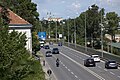
The Heiligenstädter Straße is on the one hand a feeder to the eastern, north-eastern and northern parts of the district of Oberdöbling, Heiligenstadt, Nussdorf and Kahlenbergerdorf, but also over the Grinzinger Straße to Grinzing . On the other hand, it is also an arterial road to the north to the areas south of the Danube, especially to Klosterneuburg , but also beyond to the southern Tullnerfeld . Wiener Gürtel Straße B221, Gürtelbrücke , Donaukanal Straße B227, Nussdorfer Brücke and Klosterneuburger Straße B14 have partially taken over this function, so that the area between the junction to the Gürtelbrücke and the confluence of the B14 north of Nussdorf is bypassed; at its beginning of Nussdorferstrasse to Gürtelbrücke however, the Heiligenstädterstraße part of the Wiener Gürtelstraße B221 and from the junction north of Nussdorf part of Klosterneuburger B14 and Main B. In the intermediate section is them as main A classified.
Transportation
From Liechtenwerder Platz to Nussdorfer Platz, tram line D runs on Heiligenstädter Straße; the section from Nussdorfer Straße to Liechtenwerder Platz or Glatzgasse, which was previously used by Line 8 until it was closed, is only used as an operating track.
At the Spittelau U-Bahn and S-Bahn station you can change to the U4 and U6 underground lines , to the Franz-Josefs-Bahn and the S40 S-Bahn lines, as well as to the 35A and bus lines 37A.
Another traffic junction is in the area of Karl-Marx-Hof and the Heiligenstadt train station to the east, which is also the terminus of the U4 underground line, where several bus lines end. These cross Heiligenstädter Straße and use it partly in the course of their loop journeys, for example lines 10A and 39A via Barawitzkagasse - Gunoldstraße, 38A via Grinzinger Straße as well as several regional bus lines that run from here through Heiligenstädter Straße to the Vienna city limits and on to Klosterneuburg .
At Nussdorfer Platz you can change again to the Franz-Josefs-Bahn or the S40 S-Bahn at the Vienna Nussdorf train station.
Notable addresses
(Listed objects are highlighted in bold.)
- No. 4: Municipal housing Gall-Hof, built 1924–1925 according to plans by Alfred Chalusch , Heinrich Schopper (address: Latschkagasse 3–5)
- No. 11-25: Dittes-Hof
- after No. 27: bridge of the connecting arch of the Vienna light rail (now line U6)
- after No. 29: Bridge of the former belt line of the Viennese light rail
- No. 55–63: Döbling Private Clinic
- according to No. 75A, 70: bridge of the suburb line
- No. 80: Svoboda-Hof
- No. 82-92: Karl-Marx-Hof
- No. 101: Unterheiligenstadt parish church
- No. 129: Municipal housing from the years 1953–1954 based on plans by Josef Hoffmann and Josef Kalbac; above the entrance natural stone relief family by Heinz Leinfellner
- No. 146: Municipal housing by Alfred Castellitz (1925/26)
- No. 151: Plastic Men in Conversation with Hilde Uray from 1956–1961
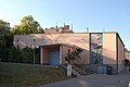
- No. 155: Volksheim based on plans by Gustav Peichl (1961) with a mosaic made of glass stones Knowledge makes free by Roman Haller (1960/61); House Döbling of the adult education center Alsergrund Währing Döbling
- at No. 163: stele work by Ferdinand Opitz (1951–1953)
- behind No. 357: Baroque garden portal (marked 1609)
Picture gallery

Gall yard

Heiligenstädter Straße 12 (Identifying addresses: Liechtenwerder Platz 2, Liechtensteinstraße 159)

Liechtenwerder Platz

Federal Office Building

City railway
bridges over Heiligenstädter Straße 1990 (the footbridge to the Spittelau station is still missing) ...
... and in 2020 (the bridge to the Spittelau station covers the bridge of the belt line)

Dittes Court

Bridge of the suburban line

Svoboda farm

Karl-Marx-Hof
Volksheim, adult education center

Sitting people or men in conversation

Unterheiligenstädter parish church

Relief above the entrance to the community building at Heiligenstädter Straße 129

At Grinzinger Straße, looking towards the city

Municipal housing at Heiligenstädter Strasse 146

Nussdorf train station

Kahlenbergerdorf, on the left the Heiligenstädter Straße

North of Kahlenbergerdorf, looking towards the city
Near the city limits in front of Klosterneuburg


_-_Karl-Marx-Hof_(2).JPG)


_-_Bahnhof_Nussdorf_(2).JPG)


literature
- Federal Monuments Office (publisher): Dehio manual. The art monuments of Austria. Vienna X. to XIX. and XXI. to XXIII. District. Verlag Anton Schroll & Co., ISBN 3-7031-0693-X (quoted as Dehio )