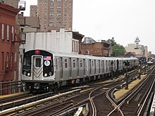
M subway line (New York City)
 6th Avenue Local |
|||||||||||||||||||||||||||||||||||||||||||||||||||||||||||||||||||||||||||||||||||||||||||||||||||||||||||||||||||||||||||||||||||||||||||||||||||||||||||||||||||||||||||||||||||||||||||||||||||||||||||||||||||||||||||||||||||||||||||||||||||||||||||||||||||||||||||||||||
|---|---|---|---|---|---|---|---|---|---|---|---|---|---|---|---|---|---|---|---|---|---|---|---|---|---|---|---|---|---|---|---|---|---|---|---|---|---|---|---|---|---|---|---|---|---|---|---|---|---|---|---|---|---|---|---|---|---|---|---|---|---|---|---|---|---|---|---|---|---|---|---|---|---|---|---|---|---|---|---|---|---|---|---|---|---|---|---|---|---|---|---|---|---|---|---|---|---|---|---|---|---|---|---|---|---|---|---|---|---|---|---|---|---|---|---|---|---|---|---|---|---|---|---|---|---|---|---|---|---|---|---|---|---|---|---|---|---|---|---|---|---|---|---|---|---|---|---|---|---|---|---|---|---|---|---|---|---|---|---|---|---|---|---|---|---|---|---|---|---|---|---|---|---|---|---|---|---|---|---|---|---|---|---|---|---|---|---|---|---|---|---|---|---|---|---|---|---|---|---|---|---|---|---|---|---|---|---|---|---|---|---|---|---|---|---|---|---|---|---|---|---|---|---|---|---|---|---|---|---|---|---|---|---|---|---|---|---|---|---|---|---|---|---|---|---|---|---|---|---|---|---|---|---|---|---|---|---|---|---|---|---|---|---|---|---|---|---|---|---|---|---|---|---|
|
Geographical plan of New York with the M
| |||||||||||||||||||||||||||||||||||||||||||||||||||||||||||||||||||||||||||||||||||||||||||||||||||||||||||||||||||||||||||||||||||||||||||||||||||||||||||||||||||||||||||||||||||||||||||||||||||||||||||||||||||||||||||||||||||||||||||||||||||||||||||||||||||||||||||||||||
| Gauge : | 1435 mm ( standard gauge ) | ||||||||||||||||||||||||||||||||||||||||||||||||||||||||||||||||||||||||||||||||||||||||||||||||||||||||||||||||||||||||||||||||||||||||||||||||||||||||||||||||||||||||||||||||||||||||||||||||||||||||||||||||||||||||||||||||||||||||||||||||||||||||||||||||||||||||||||||||
|
|||||||||||||||||||||||||||||||||||||||||||||||||||||||||||||||||||||||||||||||||||||||||||||||||||||||||||||||||||||||||||||||||||||||||||||||||||||||||||||||||||||||||||||||||||||||||||||||||||||||||||||||||||||||||||||||||||||||||||||||||||||||||||||||||||||||||||||||||
| Explanation | |||||||||||||||||||||||||||||||||||||||||||||||||||||||||||||||||||||||||||||||||||||||||||||||||||||||||||||||||||||||||||||||||||||||||||||||||||||||||||||||||||||||||||||||||||||||||||||||||||||||||||||||||||||||||||||||||||||||||||||||||||||||||||||||||||||||||||||||||
| The M line runs from “Williamsburg Bridge” underground and as a local on the IND 6th Avenue Line . | |||||||||||||||||||||||||||||||||||||||||||||||||||||||||||||||||||||||||||||||||||||||||||||||||||||||||||||||||||||||||||||||||||||||||||||||||||||||||||||||||||||||||||||||||||||||||||||||||||||||||||||||||||||||||||||||||||||||||||||||||||||||||||||||||||||||||||||||||
The line M is a line of New York City Subway and runs from Middle Village Metropolitan Ave by Forest Hills - 71st Ave . At night, she goes only from Middle Village Metropolitan Ave by Myrtle Ave .
history
Line M was until recently a sister line to lines J and Z and operated on the Nassau Street Line, which was built between 1908 and 1916 by BMT, Brooklyn-Manhattan Transit Corporation . It ran from Middle Village-Metropolitan Avenue to Broad Street in south Manhattan until 2010. At times it drove from Broad Street on a connection route, which is no longer used by regular services, to the Montague Street Tunnel (line R) and on to Brooklyn and on one of the three possible routes to Coney Island, most recently on the route of the line D.
Line V was introduced in 2001 as a replacement for Line F, which was no longer running under 53rd Street due to a new line. Line V ran consistently as a local from Forest Hills - 71st Avenue in Queens to 2nd Avenue, South Manhattan.
Due to financial problems of the operating company MTA, it was decided to connect line M with V, which also happened on June 28, 2010. For this purpose, the new combination line M uses a connecting curve that turns northward from the Nassau Street Line between Essex St and Bowery and meets the lines B and D shortly thereafter. This connecting curve was built on the occasion of a major renovation project in the area of the Manhattan Bridge in the 1960s and was only used briefly by a K line.
Line MJ
The MJ line was an elevated railway between Middle Village Metropolitan Ave and Jay Street in Brooklyn, it used parts of today's M.
Before 1937, the MJ's forerunner trains ran over Brooklyn Bridge to Manhattan, then they were pulled back to the Sands Street junction. On March 5, 1944, the Myrtle Avenue line west of Bridge-Jay Streets was closed, and a new terminal with a connection to the IND subway was opened there. In 1967, the Myrtle Avenue line was assigned the MJ sign . The MJ was only so named on maps and signs, the wagons on this route never had any signs.
After a fire, the western section of the Myrtle Avenue line was closed on October 4, 1969, the rest was left to the M line .

|
|||||||||||||||||||||||||||||||||||||||||||||||||||||||||||||||||||||||||
|---|---|---|---|---|---|---|---|---|---|---|---|---|---|---|---|---|---|---|---|---|---|---|---|---|---|---|---|---|---|---|---|---|---|---|---|---|---|---|---|---|---|---|---|---|---|---|---|---|---|---|---|---|---|---|---|---|---|---|---|---|---|---|---|---|---|---|---|---|---|---|---|---|---|
| Gauge : | 1435 mm ( standard gauge ) | ||||||||||||||||||||||||||||||||||||||||||||||||||||||||||||||||||||||||
|
|||||||||||||||||||||||||||||||||||||||||||||||||||||||||||||||||||||||||


