List of municipalities in the Ammerland district
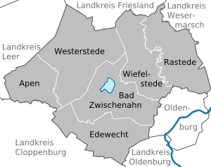
The list of municipalities in the district of Ammerland gives an overview of the six smallest administrative units in the district . With only six municipalities, it is the district in Germany with the fewest municipalities in the district. The district town of Westerstede is the only town in the district. All communities in the district are unitary communities .
The district was created in the course of the Oldenburg administrative reform in 1933 from the Westerstede office and the communities of Rastede and Wiefelstede from the Oldenburg office . At this point in time, the six large parishes that still exist today were created, whose demarcation was based on the old parish boundaries. Until 1939, the district of Ammerland was still called Amt Westerstede. As a result of the district reform carried out in 1977, the district of Friesland was dissolved and the three communities in the south of this district, Bockhorn , Zetel and the city of Varel , became part of the district of Ammerland. Due to various constitutional complaints before the Lower Saxony State Court, the reorganization of the Friesland / Wittmund area was withdrawn on January 1, 1980 and the Ammerland, Friesland and Wittmund districts were restored to their previous form. The Ammerland district is now back to its original size.
description
The district has a total area of 728.23 km 2 . The district town Westerstede has the largest area within the district with 179.0 km 2 . Four other municipalities in the district have an area larger than 100 km 2 . The smallest municipality in terms of area is Apen with 76.83 km 2 .
The municipality of Bad Zwischenahn has the largest share of the population of the district of 124,859 inhabitants with 28,896 inhabitants. Three other communities, including the city of Westerstede , have over 20,000 inhabitants. The two smallest municipalities in terms of population are Wiefelstede with 16,162 inhabitants and Apen with 11,692 inhabitants.
The entire district of Ammerland has a population density of 171 inhabitants per km 2 . The highest population density within the district is in the municipality of Bad Zwischenahn with 222 inhabitants per km 2 . In the other five municipalities, the population density is between 100 and 200 inhabitants per km 2 . In two of these municipalities the population density is higher, in three lower than the rural district average of 171. The least populated municipality is the city of Westerstede with 128 inhabitants per km 2 .
Legend
- Municipality : Name of the municipality or city
- Coat of arms : coat of arms of the municipality or city
- Map : Shows the location of the municipality or city in the district
- Area : Area of the city or municipality, given in square kilometers
- Population : number of people living in the municipality or city (as of December 31, 2019)
- Population density : The population density is given, calculated on the area of the administrative unit, given in population per km 2 (as of December 31, 2019)
- Altitude : Altitude of the eponymous town or town in meters above sea level
- Image : Image from the respective municipality or city
Communities
| local community | coat of arms | map | surface | Residents | EW density |
height | image |
|---|---|---|---|---|---|---|---|
| Ammerland district |  |
 |
728.23 | 124,859 | 171 |
 
|
|
| Apen |  |
 |
76.83 | 11,692 | 152 | 3 |

|
| Bad Zwischenahn |  |
 |
130.0 | 28,896 | 222 | 7th |
 
|
| Edewecht |  |
 |
113.5 | 22,453 | 198 | 10 |

|
| Rastede |  |
 |
123.0 | 22,704 | 185 | 10 |

|
| Westerstede (City) |  |
 |
179.0 | 22,952 | 128 | 6th |

|
| Wiefelstede |  |
 |
106.0 | 16,162 | 152 | 16 |

|
