
List of municipalities in the district of Friesland

The list of municipalities in the district of Friesland gives an overview of the eight smallest administrative units in the district . Three of the municipalities are cities . Schortens and Varel are medium- sized towns , Jever , the seat of the district administration, is a small town .
The district was created in the course of the Oldenburg administrative reform in 1933 from the Jever office and most of the Varel office . Until it was renamed the District of Friesland in 1939, it was still called Amt Friesland . As a result of the district reform carried out in 1977, the district of Friesland was dissolved and the three communities in the south of the district, Bockhorn , Zetel and the city of Varel, were reclassified into the district of Ammerland . The other communities, Jever , Sande , Schortens , Wangerland and Wangerooge were combined with the East Frisian district of Wittmund to form the new greater district of Friesland. Wittmund became the county seat . Due to various constitutional complaints before the Lower Saxony State Court, the reorganization of the Friesland / Wittmund area was withdrawn on January 1, 1980 and the Ammerland, Friesland and Wittmund districts were restored to their previous form.
The year in which they joined the municipality is noted for the suburbs of the municipalities. This is also noted for the suburbs that belonged to a different district than the main town of today's municipality before the regional reform. All communities in the district are unitary communities .
description
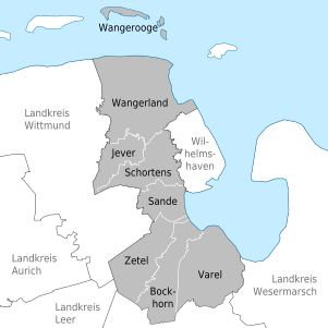
The district has a total area of 607.85 km 2 . The largest area within the district has the municipality of Wangerland with 176.0 km 2 and the city of Varel with 113.53 km 2 . Each municipality has an area larger than 80 km 2 , 70 km 2 or 60 km 2 (city of Schortens ). Two municipalities cover an area of over 40 km 2 , including the city of Jever . The smallest area has the municipality of Wangerooge with 7.94 km 2 , which includes the island of Wangerooge and the uninhabited island of Minsener Oog .
The cities of Varel with 24,017 inhabitants, Schortens with 20,381 inhabitants and Jever with 14,413 inhabitants have the largest share of the population of the district of 98,704 inhabitants. Two other municipalities have over 10,000 inhabitants and one each over 9,000 and 8,000 respectively. The smallest municipality in terms of area, Wangerooge is also the smallest in terms of population with 1214 inhabitants.
The entire district of Friesland has a population density of 162 inhabitants per km 2 . The largest population density within the district are the cities of Jever with 342 inhabitants per km 2 , Schortens with 297 and Varel with 212, followed by the municipality of Sande with 195. The other four municipalities have a lower population density than the district average of 162. Three of these municipalities have a population density over 100, one - Wangerland with 52 inhabitants per km 2 - under 100.
Legend
- Municipality : Name of the municipality or city
- Subsites : Enumerated are the formerly independent municipalities of the administrative unit. The year of incorporation is also given. This is also noted for the suburbs that belonged to a different district than the main town of today's municipality before the regional reform
- Coat of arms : coat of arms of the municipality or city
- Map : Shows the location of the municipality or city in the district
- Area : Area of the city or municipality, given in square kilometers
- Population : number of people living in the municipality or city (as of December 31, 2019)
- Population density : The population density is given, calculated on the area of the administrative unit, given in population per km 2 (as of December 31, 2019)
- Altitude : Altitude of the eponymous town or town in meters above sea level
- Image : Image from the respective municipality or city
Communities
| local community | Sub-locations | coat of arms | map | surface | Residents | EW density |
height | image |
|---|---|---|---|---|---|---|---|---|
| District of Friesland |  |
 |
607.85 | 98,704 | 162 |

|
||
| Bockhorn | Bockhorn |  |
 |
77.15 | 8,892 | 115 | 6th | |
| Jever (district town) | Jever |  |
 |
42.13 | 14,413 | 342 | 9 |

|
| Sands |
Sande Gödens (1972; belonged to the Wittmund district before the regional reform) |
 |
 |
45.0 | 8,792 | 195 | 0 |
 
|
| Schortens (city) |
Schortens Sillenstede (1972) |
 |
 |
68.67 | 20,381 | 297 | 6th |

|
| Varel (city) | Varel-Stadt Varel-Land (merger 1972) |
 |
 |
113.53 | 24,017 | 212 | 8th |
 
|
| Wangerland |
Hohenkirchen Hooksiel Minsen Tettens Waddewarden (merger 1972) |
 |
 |
176.0 | 9,182 | 52 | 2 |

|
| Wangerooge | Wangerooge |  |
 |
7.94 | 1,214 | 153 | 8th |
 
|
| Zetel |
Zetel Neuchâtel (1972) |
 |
 |
81.26 | 11,813 | 145 | 10 |

|
Individual evidence
- ↑ State Office for Statistics Lower Saxony, LSN-Online regional database, Table 12411: Update of the population, as of December 31, 2019 ( help ).
- ↑ State Office for Statistics Lower Saxony, LSN-Online regional database, Table 12411: Update of the population, as of December 31, 2019 ( help ).
Ammerland | Aurich | Celle | Cloppenburg | Cuxhaven | Diepholz | Emsland | Friesland | Gifhorn | Goslar | Göttingen | County of Bentheim | Hameln-Pyrmont | Hannover Region | Harburg | Heidekreis | Helmstedt | Hildesheim | Holzminden | Empty | Lüchow-Dannenberg | Lüneburg | Nienburg / Weser | Northeim | Oldenburg | Osnabrück | Osterholz | Peine | Rotenburg (Wümme) | Schaumburg | Stade | Uelzen | Vechta | Verden | Wesermarsch | Wittmund | Wolfenbüttel