List of listed objects in Hofkirchen im Mühlkreis
The list of listed objects in Hofkirchen im Mühlkreis contains the 15 listed , immovable objects of the municipality Hofkirchen im Mühlkreis in Upper Austria ( Rohrbach district ).
Monuments
| photo | monument | Location | description | Metadata |
|---|---|---|---|---|

|
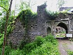
Falkenstein Ruins ObjectID: 14412 |
Falkenstein 1 location KG: Hofkirchen |
The structurally very extensive castle complex comprised a total built-up area of 2960 square meters. At the top of the rock formation converging to the west above the Ranna valley was the keep on the outermost rock slab, to which the main castle with the palas adjoined, which was dominated by two towers. |
ObjectID: 14412 Status: Notification Status of the BDA list: 2020-02-29 Name: Falkenstein Ruin GstNr .: .105; 5530 Falkenstein Castle on the Ranna |

|
Former Meierhof of Altenhof Castle ObjectID : 14370 |
Falkenstein 2 location KG: Hofkirchen |
The former Meierhof of Altenhof Castle was built in the first half of the 19th century and had to be renovated after a fire in the middle of the 20th century. |
ObjectID : 14370 Status : Notification Status of the BDA list: 2020-02-29 Name: Former Meierhof of Schloss Altenhof GstNr .: .108 Meierhof of Schloss Altenhof |

|
Shrine Object ID: 14360 |
Hofkirchen im Mühlkreis KG location : Hofkirchen |
The two tabernacle columns near the so-called water basin date from the 17th century, with one column being marked with the year 1671 . |
ObjectID : 14360 Status: § 2a Status of the BDA list: 2020-02-29 Name: wayside shrine GstNr .: 5098 |

|
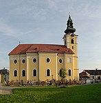
Catholic parish church hl. Ulrich ObjectID : 14402 |
Hofkirchen im Mühlkreis KG location : Hofkirchen |
The three-bay, late baroque hall church with half a front bay in front of the mighty west tower has a two-bay rectangular choir and a two-storey, south-facing extension that serves as a sacristy or oratory. The church was rebuilt after a fire in 1636 and finally rebuilt in the first half of the 18th century with the addition of the Gothic tower. |
ObjectID : 14402 Status: § 2a Status of the BDA list: 2020-02-29 Name: Catholic parish church hl. Ulrich GstNr .: .1 / 1; .1 / 2 Saint Ulrich church in Hofkirchen iM |

|
Pillory ObjectID : 14364 |
Market location KG: Hofkirchen |
The pillory in front of the town hall consists of an obelisk-like stone pillar with a profiled cornice, a spherical top and a renewed sheet metal flag. The pillory, erected around 1680, is marked with the year 1335 , the wrong year of the market survey. |
ObjectID : 14364 Status: § 2a Status of the BDA list: 2020-02-29 Name: Pranger GstNr .: 4258/9 Pranger Hofkirchen |

|
Fountain ObjectID : 14374 |
Market location KG: Hofkirchen |
The market fountain with an octagonal stone basin is marked with the year 1675 . The baluster-like fountain column with a base was subsequently replaced at the upper end by a cube capital on which there is a slender obelis with triangular reliefs crowned with lilies. The fountain is fed by two small gargoyles with animal grimaces. |
ObjectID : 14374 Status: § 2a Status of the BDA list: 2020-02-29 Name: Brunnen GstNr .: 4258/9 Marktbrunnen Hofkirchen |

|
Residential building ObjectID : 14379 |
Market 4 location KG: Hofkirchen |
The so-called bourgeois Gmain was converted into a vicar's house in 1832 and has been owned by the community since 1877. |
ObjectID : 14379 Status : Notification Status of the BDA list: 2020-02-29 Name: Residential house GstNr .: .19 / 2 Markt 4 (Hofkirchen im Mühlkreis) |

|
Bürgerhaus ObjektID : 14397 |
Markt 5 KG location : Hofkirchen |
The town house has been documented since 1672. |
ObjectID : 14397 Status: § 2a Status of the BDA list: 2020-02-29 Name: Bürgerhaus GstNr .: .17 Markt 5 (Hofkirchen im Mühlkreis) |

|
Bürgerhaus ObjektID : 14407 |
Markt 6 KG location : Hofkirchen |
ObjectID : 14407 Status : Notification Status of the BDA list: 2020-02-29 Name: Bürgerhaus GstNr .: .19 / 1 Markt 6 (Hofkirchen im Mühlkreis) |
|

|
Town Hall / Municipal Office ObjectID : 14375 |
Markt 8 KG location : Hofkirchen |
The municipal office has been documented since 1623 and was rebuilt in 1962. The Renaissance portico on Tuscan columns dates from around 1600. |
ObjectID : 14375 Status : Notification Status of the BDA list: 2020-02-29 Name: Town hall / Municipal office GstNr .: .24 Municipal office Hofkirchen im Mühlkreis |

|
Bürgerhaus, so-called Mesnerhaus ObjectID : 14398 |
Pfarrgasse 3 KG location : Hofkirchen |
The town house from the 17th century has a facade with a plaster frame structure and a baroque, ear-framed entrance portal. |
ObjectID : 14398 Status : Notification Status of the BDA list: 2020-02-29 Name: Bürgerhaus, so-called Mesnerhaus GstNr .: .19 / 3 |

|
Vicarage ObjectID : 14410 |
Pfarrgasse 10 KG location : Hofkirchen |
The two-storey building of the former farm house has been documented since 1668 and was adapted as a parsonage between 1877 and 1888. |
ObjectID : 14410 Status: § 2a Status of the BDA list: 2020-02-29 Name: Pfarrhof GstNr .: 6 Pfarrhof Hofkirchen im Mühlkreis |

|
Haichenbach ruins, so-called Kerschbaumerschlössl ObjectID : 14413 |
Village location KG: Marsbach |
The former castle was an elongated complex on the narrow plateau of the ridge in a north-south direction with a total built-up area of 1450 square meters. Behind the castle gate in the north stretched the very spacious outer bailey with servants' houses. The north-east side of the castle was connected to the slightly higher main castle, which was dominated by a residential tower in the north, from which the castle gate below to the west could also be defended. The fortified tower once had ten defensive slits. |
ObjectID : 14413 Status : Notification Status of the BDA list: 2020-02-29 Name: Haichenbach ruins, so-called Kerschbaumerschlössl GstNr .: 2469/10 Haichenbach castle ruins |

|
Freizell ruins ObjektID : 16689 since 2012 |
Freizell 1 location KG: Marsbach |
The oldest parts of the complex that have been preserved date back to the 16th century. The formerly continuous hall with a tower-like central porch on the upper floor dates from this time. The rest of the floor plan shows cross-shaped internal walls with large passages. The arched arches on the outer fronts are likely to date from the 17th century. |
ObjektID : 16689 Status : Notification Status of the BDA list: 2020-02-29 Name: Ruine Freizell GstNr .: 2427/9 |

|
Marsbach Castle ObjectID: 14411 |
Marsbach 1 KG location : Marsbach |
The castle lies on a steep drop on the left side of the Danube. The three-storey, rectangular main building with a round tower bears the year 1586 in the courtyard. This is followed by the elongated south wing. On the north side there is a small round tower and in the far east you can see the square keep of the old castle. |
ObjectID: 14411 Status: Notification Status of the BDA list: 2020-02-29 Name: Marsbach Castle GstNr .: .1 Marsbach Castle |
literature
- Peter Adam, Beate Auer, u. a: Dehio Handbook Upper Austria. Volume 1, Mühlviertel. Verlag Berger, Horn, Vienna 2003, ISBN 3-85028-362-3
Web links
Commons : Listed objects in Hofkirchen im Mühlkreis - collection of images, videos and audio files
Individual evidence
- ↑ a b Upper Austria - immovable and archaeological monuments under monument protection. (PDF), ( CSV ). Federal Monuments Office , as of February 18, 2020.
- ↑ § 2a Monument Protection Act in the legal information system of the Republic of Austria .
