Llogara pass
| Qafa Llogara | |||
|---|---|---|---|
|
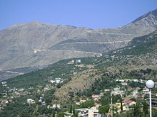
Pass road with a view of the Maja e Çikës |
|||
| Compass direction | North | south | |
| Pass height | 1027 m above sea level A. | ||
| circle | Vlora | ||
| Watershed | the Adrian Sea | Ionian sea | |
| Valley locations | Orikum | Dhërmi | |
| expansion | Street | ||
| Lock | - | ||
| Mountains | Acroceraunian Mountains | ||
| map | |||
|
|
|||
| Coordinates | 40 ° 11 ′ 55 " N , 19 ° 35 ′ 30" E | ||
The Llogara Pass ( Albanian Qafa Llogara ) is a mountain pass in southern Albania . It is part of the national road SH 8 and a watershed between the Adriatic Sea in the north and the Ionian Sea in the south. The pass leads over a western branch of the Ceraunic Mountains , the Akroceraunian Mountains , which continue to follow the coast and ends in the Karaburun peninsula in the sea off Vlora . The Llogara Pass lies between the Maja e Çikës ( 2045 m above sea level ), the highest elevation of the Ceraunic Mountains, and the Maja e Gjipalit ( 1446 m above sea level ) in the west at 1027 m above sea level. A. The pass is in the Llogara National Park .
geography
In the north of the pass the valley of Dukat leads to the southern end of the bay of Vlora near Orikum . In the south it drops steeply from the pass to the Ionian Sea, the coast of which is only three kilometers as the crow flies, but over 1000 meters lower. In contrast to the north with a narrow V-valley , the pass opens to the south, where only a few cuts in the steep coast lead to water after rainfall. The pass offers impressive views of the sea and, with good visibility, over the entire Albanian Riviera to the Greek island of Corfu, 50 kilometers away .
The mountain crossing is part of the Albanian coastal road SH 8 , which is the only paved road that connects the Ionian coast - the Albanian Riviera - with northern Albania. The road over the Qafa Llogara was expanded and expanded in 2008. The whole mountain range northwest of Qafa Llogara including the Karaburun Peninsula is uninhabited and hardly accessible.
The north and south sides of the pass differ significantly. Although on the south side with 2000–2500 mm almost twice as much rain falls per year as north of the pass (1200–1400 mm), the south slope is very bare and stony, the north slope is forested and green. The temperatures are also a lot lower on the south side.
history
In 48 BC Gaius Iulius Caesar landed in the civil war near the village of Palasa at the southern foot of the Llogara pass, crossed it and went north against Pompey in the battle of Dyrrhachium . Individual historians, however, assume that Caesar landed in a small bay ten or 15 kilometers further north, which would correspond more to the described marching time to Oricum . He would not have crossed the mountains at the Llogara Pass either.
Web links
Individual evidence
- ↑ Akademia e Shkencave e RPSSH (ed.): Fjalor enciklopedik shqiptar . Tirana 1985.
- ↑ llogara.com. Archived from the original on August 19, 2010 ; Retrieved June 7, 2011 (Albanian).
- ^ TJ Winnifrith: Badlands - Borderlands, A History of Southern Albania / Northern Epirus , Duckworth, London 2002, ISBN 0-7156-3201-9


