
Loschwitzbach
| Loschwitzbach | ||
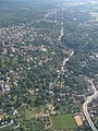
 The Loschwitzbach between Tännichtstraße and Ulrichstraße on the edge of Dresden-Rochwitz |
||
| Data | ||
| Water code | DE : 5371952 | |
| location | Dresden | |
| River system | Elbe | |
| Drain over | Elbe → North Sea | |
| source | in Bühlau , south of Ullersdorfer Straße 44 51 ° 3 ′ 55 ″ N , 13 ° 51 ′ 44 ″ E |
|
| Source height | 243 m | |
| muzzle | in Dresden - Loschwitz in the Elbe Coordinates: 51 ° 3 ′ 9 ″ N , 13 ° 48 ′ 44 ″ E 51 ° 3 ′ 9 ″ N , 13 ° 48 ′ 44 ″ E |
|
| Mouth height | 106 m | |
| Height difference | 137 m | |
| Bottom slope | 30 ‰ | |
| length | 4.6 km | |
| Drain at the mouth |
NNQ MHQ |
31 l / s 25.6 m³ / s |
| Left tributaries | Quohrener ditch , Bühlau-Rochwitzer Grenzbach, Lehmgrubenbach, Neurochwitzer Grundbach, Felsenquelle, Ziegengrundbach | |
| Right tributaries | Heidemühlgraben, Heidemühlgraben 1, Heidebach, Neugersdorfer Bach, Steglichquelle | |
| Flowing lakes | Loschwitzbachteich, rock pond | |
The Loschwitzbach (popularly known as the Trille ) is a tributary of the Elbe in the east of Dresden .
course

The stream rises in the Dresden district of Bühlau on the edge of the Dresden Heath and flows in a south-westerly direction to the Elbe. After almost five kilometers of flowing, the brook flows into the Elbe on the orographic right in Loschwitz near the Blaues Wunder bridge .
In the upper reaches, the stream has a largely natural character up to the piping at Ullersdorfer Platz. Then open and piped sections of water change to the former Bühlau outdoor pool . Up to the Elbe meadows in Loschwitz, the water is mostly piped, a 300 meter long section is the longest open section here. Even in the open water sections, the brook is usually attached to both banks.
The course of the brook today corresponds to the historical course, only in the area of Ullersdorfer Platz corrections were made.
There are 13 springs in the 5.2 square kilometer catchment area of the Loschwitzbach.
Water condition
Due to its catchment area of less than 10 square kilometers, the Loschwitzbach is not a separate body of water according to the European Water Framework Directive (WFD). The brook belongs to water body type 5 (WFD): "Coarse material rich, silicate low mountain brooks". The geological subsoil of the stream is characterized by granodiorite , clay and sand .
The body of water has been greatly changed by fortification and piping, which leads to a considerable devaluation of the ecological status. During an investigation of the water quality of the Loschwitzbach in 2001/2002 it was found that the upper reaches already had a critical load ( water quality class II-III), which deteriorated in the further course of the river by one level to quality class III (heavily polluted).
natural reserve
Parts of the water catchment area are located in the landscape protection areas Schönfelder Hochland and Elbe slopes Dresden-Pirna , Bühlauer Wiesen and Dresdner Heide.
Former mills
Since the Middle Ages there have been several watermills in Loschwitzgrund , all of which have now disappeared or been rededicated. Below are the former mills, arranged downstream.
Wage Mill
The tan mill was created for pounding oak bark from the Dresden Heath, which was needed as tanner tanning in tanning and dyeing. The Lohschänke, which the mill owner Hans Schmied bought in 1683, was later built on the wood stacking area north of the mill.
In 1847 the mill building was destroyed by fire and rebuilt 100 meters upstream. The task of the mill changed, the building was used as a grain and oil mill , as a steam laundry and finally as a bakery until 1944 . In 1930 the chimney was torn down, and in 1931 the now closed Bühlauer Bad was built from the mill pond , around which a forest rope park was set up in the meantime . The main building of the former mill is now a residential building.
Bar mill
According to tradition, the mill is said to have existed as early as the 13th century and was destroyed in the Hussite Wars (1419 to 1439). Around 1800 the miller August Wizani built a mill building again at this point, which is now used as a residential building.
Zeibigmühle

The mill was first mentioned in the 13th century. The mill's romantic location was appreciated in the 19th century. Ludwig Richter drew them in 1820 as a motif to illustrate the Eichendorff - folk song in a cool reason . With the construction of new houses around 1900 in the immediate vicinity of the mill, this was structurally renewed. Nevertheless, the former flour mill had to stop operating a little later. The actual mill building fell victim to the road expansion in 1937/38. Remains of the former mill moat have been preserved on the mountain slope to this day. The filled mill pond was used as a coal storage area for a long time.
Dam or noodle mill
The dam mill, popularly known as the noodle mill, was first mentioned in 1688. It had two ponds separated by a dam. Milling ceased in 1880 and the building was used as a sandpaper factory. Nine years later an ice cellar was set up, in which blocks of ice from the mill pond were stored in winter.
The mill building was demolished in 1936 during road works.
Board cutting mill from Hansel

The mill is mentioned for the first time in 1545. The Hanselmühle got its name from the owners in 1868. The mill was the only cutting mill on the Loschwitzer Bach, here wood from Bohemia and the Elbe Sandstone Mountains was processed on the Elbe .
In 1870 the water wheel was replaced by a steam drive in order to be able to work independently of the water level. Five years later, the plant was destroyed in a storm and rebuilt as a modern steam sawmill in 1882. After a lightning strike, the mill burned down in May 1925 and was not rebuilt.
Hansel flour mill
The mill was first mentioned in 1547. In 1860 the mill ceased operations and a brewery was built on the site.
Niedermühle (Vettermühle)
The flour mill was first mentioned in 1590 and was in operation until the middle of the 19th century. In 1842 a glass factory was operated in the mill building, and around 1850 a brief gold and silver smelter. In 1854 the ink manufacturer August Leonhardi acquired the property and built a chemical factory. The factory moved to Trachau due to the excessive environmental pollution , the buildings were demolished. In their place a park-like green area was created, which fell victim to the construction of an air raid shelter during World War II .
Hentschelmühle

The Hentschel mill was the deepest mill in the Loschwitzbachgrund and was mentioned as early as the 16th century. It belonged to the miller family Hentschel from 1785 until it was bought by the Leonhardi family in 1879. In the course of industrialization, the grinding operation was stopped in 1870 and the mill fell into disrepair.
The Leonhardi family had the mill and stables torn down in 1883 and only continued to use the former residential building, which was converted into a studio and exhibition space between 1882 and 1884. According to the original concept, the house was to be used as an artist's house for free rent for young and poor artists. The plan was not fully realized, but the highly talented painter Charles Johann Palmié lived for a long time in the now renamed Red Blackbird, which he also adorned with all sorts of sayings and historical decorations.
The exhibition building, officially operated under the name Leonhardi Museum from 1963, was mainly used by young artists for public presentations of their works until 1990.
gallery
Aerial view of the Loschwitzgrund

Headwaters of the Loschwitzbach

Natural Loschwitzbach in Bühlau

The Lehmgrubenbach flows into the Loschwitzbach

Fortified Loschwitzbach

The Loschwitzbach flows into the Elbe


Web links
- Loschwitzbach water profile (PDF; 3 MB), accessed August 11, 2020