Lourens (river)
|
Lourens Lourens River |
||
|
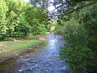
The Lourens near Vergere |
||
| Data | ||
| location | South Africa ( Western Cape Province ) | |
| River system | Lourens (river) | |
| source | Hottentots Holland Mountains, South Africa | |
| muzzle |
False Bay Coordinates: 34 ° 5 '59 " S , 18 ° 41' 48" E 34 ° 5 '59 " S , 18 ° 41' 48" E
|
|
| length | 23 km | |
| Catchment area | 128 km² | |
The Lourens is an approximately 23 km long river that flows through Cape Town , South Africa .
It rises in the mountains of the Hottentots Holland ( Western Cape Province ) and flows into False Bay at the level of the beach . The upper reaches of the river is part of the undisturbed and protected Lourens River Protected Natural Environment along with the Dick Dent Bird Sanctuary and is privately owned . The lower part of the river is characterized by fynbos vegetation and alien plant species . Due to the development of urbanization, this natural area is threatened by pollution and weeds such as Kikuyu grass (Pennisetum clandestinum) or black wattle trees . The catchment area measures around 128 km² and includes the south-eastern slopes of the Heldersberg.
Topography / geology
The landscape of Lourenstals is geologically through the zone of Cape fold belt ( Cape Fold Belt embossed) and consists of a band lying parallel ridges of quartzitic sandstone with in between valley bogs from silt and shales and there outcropping occurrence of Cape granite . The oldest deposits date back over 400 million years. Ferricrete can be found between the layers of silt and mudstone . Their solidified horizons formed around 20 million years ago when the sea level was still significantly higher. The soils are acidic and largely sterile. In the headwaters, the Hottentots Holland Mountains , there is table mountain sandstone , which is superimposed on the siltstones, claystones and greywacke of the older Malmesbury group . The landscape has remained unchanged for more than 65 million years. The river valley itself consists largely of alluvial sedimentary soil, overlaid by boulders and clay . The Lourens carries 87% of its water in the winter months. The average volume of water carried is around 59,000,000 m³.
Fauna / flora

Trout fishing is a popular pastime on the Lourens. This is regulated by nature conservation measures from 1974. Seals , bony fish , copepods and barnacles , rotifers and protozoa can be found in the mouth of the river . Twelve species of frogs live on land; there are also eleven species of snakes and eight lizards, such as the colorful dwarf chameleon . Also threatened with extinction is the Psammobotes geometricus , a tortoise species equipped with a shell formation of geometric tent arrangements . Of the 33 bird species at the Lourens estuary, the most common are the sanderling and the common tern . There are also three species of bat . Certain shrews and gerbils , rats , baboons , antelopes , naked mole rats and otters are at home here. The serval and leopard can be found on big cats .
In the Lourens catchment area there are some fynbos at the foot of the mountains. Due to urbanization, the natural vegetation has been pushed back and thus become rarer. Nevertheless, there is a biodiversity of up to 2500, partly endemic , plants. Willows, poplars, rushes , sour grasses , reeds and sweet grasses ( Paspalum vaginatum ) are predominant . Epiphytic diatoms can be found in the river mouth as well as unicellular, colonial green algae ( Scenedesmus and Coelastrum species ) or flat intestinal wrack , dwarf thread algae and cladophora from the class of Siphonocladophyceae , which cover the surface and the bed of the mouth like mats. Salt marsh vegetation along the estuary, however, is not to be found.
climate
The average annual temperature is 20 ° C. There are big differences in the temperature range between summer and winter, whereby the temperature gradient between day and night is not extreme. Snow can appear at higher altitudes in winter. The prevailing wind direction is south-east or north-west, with occasional very strong wind conditions.
The mean annual precipitation is around 1200 mm near the mountains and 915 mm in the flat regions. The mean annual rainfall on the Lourens is 1002 mm, while the mean annual evaporation is calculated to be 1410 mm.
Agriculture
The vineyards and orchards together cover 20% of the catchment area on the Lourens River. In particular, apples, pears, plums and lemons are grown. Viticulture is of particular importance in the region. The varieties Cabernet Sauvignon , Syrah , Merlot , Chardonnay and Sauvignon Blanc are cultivated . At the winery Vergelegen are over 300 years old camphor trees that have been declared a national monument. Sheep and cattle breeding are among the most important agricultural sources of income.
See also
Individual evidence
- ↑ a b DWAF, 2003. State-of-Rivers Report, River Health Program (2003). Diep, Hout Bay, Lourens and Palmiet River Systems.
- ↑ a b c d Estuaries of the Cape Report No. 17 Lourens (CSW 7) CSIR RESEARCH REPORT 416.
- ↑ Environmental Resource Management ( Memento of the original from January 22, 2014 in the Internet Archive ) Info: The archive link was automatically inserted and not yet checked. Please check the original and archive link according to the instructions and then remove this notice.
- ↑ LOURENS RIVER: Topography, geology and soils ( Memento of the original from June 4, 2016 in the Internet Archive ) Info: The archive link was inserted automatically and has not yet been checked. Please check the original and archive link according to the instructions and then remove this notice.
