
Martely
| Martely | |||||
|
|||||
| Basic data | |||||
|---|---|---|---|---|---|
| State : | Hungary | ||||
| Region : | Southern Great Plain | ||||
| County : | Csongrád-Csanád | ||||
| Small area until December 31, 2012 : | Hódmezővásárhely | ||||
| District since 1.1.2013 : | Hódmezővásárhely | ||||
| Coordinates : | 46 ° 28 ' N , 20 ° 14' E | ||||
| Area : | 36.45 km² | ||||
| Residents : | 1,349 (Jan. 1, 2011) | ||||
| Population density : | 37 inhabitants per km² | ||||
| Telephone code : | (+36) 62 | ||||
| Postal code : | 6636 | ||||
| KSH kódja: | 25733 | ||||
| Structure and administration (as of 2020) | |||||
| Community type : | local community | ||||
| Mayoress : | Anita Putz (independent) | ||||
| Postal address : | Rákóczi tér 1 6636 Mártély |
||||
| Website : | |||||
| (Source: A Magyar Köztársaság helységnévkönyve 2011. január 1st at Központi statisztikai hivatal ) | |||||


Mártély is a Hungarian community in the district Hódmezővásárhely in Csongrád-Csanád . It lies on a dead arm of the Tisza . Mártély has 1301 inhabitants (as of 2015).
Community partnerships
-
 Verbandsgemeinde Altenahr , Germany
-
 Detk , Hungary
 -
 Eremitu , Romania
-
 Trešnjevac (Трешњевац), Serbia
Attractions
- Landscape protection area on the Tisza
- Roman Catholic Church Szent Adorján , built 1910–1911
- Windmill ( Késmárki Imre-féle szélmalom )
traffic
The road no. 4521 runs through Mártély. The village is connected to the railway line from Szentes to Hódmezővásárhely .
photos
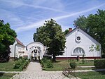
Municipal administration in Mártély

Train station in Mártély

Old farmhouse in Mártély


Individual evidence
- ↑ Helyi önkormányzati választások 2019 - Mártély (Csongrád megye). Nemzeti Választási Iroda, October 13, 2019, accessed on June 13, 2020 (Hungarian).
Web links
- Official website (Hungarian)