
Hermit
|
Eremitu Nyárádremete |
|||||
|
|||||
| Basic data | |||||
|---|---|---|---|---|---|
| State : |
|
||||
| Historical region : | Transylvania | ||||
| Circle : | Mureș | ||||
| Coordinates : | 46 ° 40 ′ N , 24 ° 55 ′ E | ||||
| Time zone : | EET ( UTC +2) | ||||
| Height : | 491 m | ||||
| Area : | 83.11 km² | ||||
| Residents : | 3,893 (October 20, 2011) | ||||
| Population density : | 47 inhabitants per km² | ||||
| Postal code : | 547210 | ||||
| Telephone code : | (+40) 02 65 | ||||
| License plate : | MS | ||||
| Structure and administration (as of 2016) | |||||
| Community type : | local community | ||||
| Structure : | Eremitu, Călugăreni , Câmpu Cetății , Dămieni , Mătrici | ||||
| Mayor : | Péter Magyári ( UDMR ) | ||||
| Postal address : | Str. Principală, no. 547 loc. Hermit, jud. Mureș, RO-547210 |
||||
| Website : | |||||


Eremitu (outdated Remetea Secuiască ; Hungarian Nyárádremete also Köszvényesremete ) is a municipality in Mureș County , in the Transylvania region in Romania .
Geographical location

The municipality of Eremitu is located north of the Kokel Highlands (Podișul Târnavelor) in the Transylvanian Basin . On the Niraj (Niersch) - a left tributary of the Mureș (Mieresch) - and the district road (Drum județean) DJ 153, the place Eremitu is 19 kilometers northwest of the small town of Sovata and about 38 kilometers northeast of the district capital Târgu Mureș (Neumarkt am Mieresch) removed. The incorporated villages are three to nine kilometers from the community center.
history
The place Eremitu, founded by Szekler , was first mentioned in 1567.
An earlier settlement of the place Eremitu, with the five remains of castle ruins on its area (Izvorul mirajului (Nyárádfö), Curmătura (Szakadát), Cetatea lui Tompa (Tompatetö), Cetatea Vityál (Vityálvára), Cetatea Bélmezöra) , was still not assigned to any age , a stone ax, however, to the Neolithic .
On the area of the incorporated village of Călugăreni (Hungarian : Mikháza ) remains of the Roman fort Călugăreni and other archaeological findings from the Roman era were found. A Roman road is recorded in Călugăreni and Dămieni (Deményháza) .
In the Kingdom of Hungary , today's municipality belonged to the Nyáradszereda chair district in Maros-Torda County , then to the historical Mureș District and, from 1950, today's Mureș District.
population
The population of the municipality of Eremitu developed as follows:
| census | Ethnic composition | ||||
|---|---|---|---|---|---|
| year | population | Romanians | Hungary | German | other |
| 1850 | 2,907 | 113 | 2,637 | 2 | 155 |
| 1920 | 4,078 | 264 | 3,698 | 11 | 105 |
| 1956 | 5,177 | 245 | 4,886 | 8th | 38 |
| 2002 | 3,872 | 140 | 3,561 | 3 | 168 |
| 2011 | 3,893 | 163 | 3,465 | - | 265 |
Since 1850, the highest number of inhabitants and that of the Magyars were registered in the area of today's municipality in 1956. The highest population of Romanians (288) was determined in 1966, that of Roma (270) in 1930 and that of Romanian Germans in 1920.
Attractions
- In the community center, the two castles Cetatea Mare and Cetatea Mică on the area called Tâmpa (Hungarian Tompa ) by the locals are assigned to Roman times , the Cetatea Vityál (Vityálvára) castle, according to the Romanian Ministry of Culture, was assigned to the 12th century. The Roman Catholic Church, built in the 15th century, is a listed building.
- In the incorporated village of Călugăreni, on the Ținutul Cetății area, the archaeological excavation site Fort Călugăreni and the Roman Catholic church of the former Franciscan monastery, built from 1666 to 1678, are listed.
- In the incorporated village of Câmpu Cetății (Vármező) , a ring wall at seven and a half kilometers from the summit Dealul Cetă Gipfelii , is a listed building.
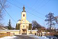
Church in Eremitu
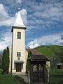
Church in Câmpu Cetății

Church in Călugăreni

Church in Mătrici
.jpg)

.jpg)
.jpg)
Personalities
- Szabó János (1767-1858), born in Mătrici, was a Hungarian writer.
Web links
- Website of the municipality of Eremitu (rich in information) (Hungarian)
- Eremitu at ghidulprimariilor.ro
Individual evidence
- ↑ 2011 census in Romania ( MS Excel ; 1.3 MB)
- ↑ Arcanum Kézikönyvtár: Historical-administrative book of place names of Transylvania, Banat and Partium. Retrieved June 26, 2018 (Hungarian).
- ↑ Heinz Heltmann, Gustav Servatius (Ed.): Travel Guide Siebenbürgen . Kraft, Würzburg 1993, ISBN 3-8083-2019-2 , p. 517 .
- ↑ Institute Of Archeology - Eremitu , accessed June 28, 2018 (Romanian).
- ↑ Information on the Roman camp in Călugăreni at cronica.cimec.ro/ accessed on June 29, 2018 (Romanian)
- ^ Institute Of Archeology - Călugăreni , accessed June 29, 2018 (Romanian).
- ↑ Institute Of Archeology - Dămieni , accessed on 29 June 2018 (Romanian).
- ↑ Censuses 1850–2002, last updated November 2, 2008 (PDF; 1 MB; Hungarian)
- ↑ a b c List of historical monuments of the Romanian Ministry of Culture, updated 2015 (PDF; 12.7 MB; Romanian)
- ↑ Information on the Reformed Church in Călugăreni at biserici.org, accessed on June 29, 2018 (Romanian)
- ↑ Szabó János at lexikon.katolikus.hu/ accessed on June 28, 2018 (Hungarian)
Acățari | Adămuș | Albeşti | Aluniș | Apold | Ațintiș | Băgaciu | Bahnea | Băla | Bălăușeri | Band | Batoș | Beica de Jos | Bereni | Bichiș | Bogata | Brâncoveneşti | Breaza | Ceuașu de Câmpie | Chețani | Chiheru de Jos | Coroisânmărtin | Corunca | Cozma | Crăciuneşti | Crăiești | Cristești | Cucerdea | Cuci | Daneș | Deda | Hermit | Ernei | Fântânele | Fărăgău | Gălești | Găneşti | Gheorghe Doja | Ghindari | Glodeni | Gorneşti | Grebenișu de Câmpie | Gurghiu | Hodac | Hodoșa | Ibăneşti | Iclănzel | Ideciu de Jos | Livezeni | Lunca | Lunca Bradului | Măgherani | Mica | Miheșu de Câmpie | Nadeș | Neaua | Ogra | Pănet | Papiu Ilarian | Păsăreni | Petelea | Pogăceaua | Râciu | Răstolița | Rușii-Munți | Sâncraiu de Mureș | Sângeorgiu de Mureș | Singer | Sânpaul | Sânpetru de Câmpie | Sântana de Mureș | Saschiz | Sărățeni | Șăulia | Șincai | Solovăstru | Stânceni | Suplac | Suseni | Tăureni | Valea Largă | Vânători | Vărgata | Vătava | Vețca | Viișoara | Voivodeni | Zagăr | Zau de Câmpie