
Saschiz
|
Saschiz Keisd Szászkézd |
|||||
|
|||||
| Basic data | |||||
|---|---|---|---|---|---|
| State : |
|
||||
| Historical region : | Transylvania | ||||
| Circle : | Mureș | ||||
| Coordinates : | 46 ° 11 ' N , 24 ° 58' E | ||||
| Time zone : | EET ( UTC +2) | ||||
| Height : | 410 m | ||||
| Area : | 98.21 km² | ||||
| Residents : | 1,965 (October 20, 2011) | ||||
| Population density : | 20 inhabitants per km² | ||||
| Postal code : | 547510 | ||||
| Telephone code : | (+40) 02 65 | ||||
| License plate : | MS | ||||
| Structure and administration (as of 2016) | |||||
| Community type : | local community | ||||
| Structure : | Saschiz, Cloașterf , Mihai Viteazu | ||||
| Mayor : | Ovidiu Șoaita ( PNL ) | ||||
| Postal address : | Str. Principală, no. 159 loc. Saschiz, jud. Mureș, RO-547510 |
||||
| Website : | |||||


Saschiz ( German Keisd , Hungarian Szászkézd ) is a municipality in the Mureș district in the Transylvania region in Romania .
Geographical location


The municipality of Saschiz is located in the Kokel highlands (Podișul Târnavelor) , roughly in the south of the Transylvanian Basin in the south of the Mureș district. Located on the stream of the same name and the European route 60 , the place Saschiz is about 20 kilometers east of the small town Sighișoara (Schäßburg) ; the district capital Târgu Mureș (Neumarkt am Mieresch) is located about 70 kilometers northwest of Saschiz.
Saschiz does not have a train station. The closest is in Vânători , about 10 kilometers north, on the Teiuș – Brașov railway line .
history
Keisd was founded as a primary settlement of the Repser Stuhl during the first wave of settlement on Königsboden in the 12th century by German settlers ( Transylvanian Saxons ). The place was first mentioned in a document in 1309.
Carpentry and wood dyeing were the most widespread craft businesses.
Attractions
- In the center of the village is the Gothic style Evangelical church from 1496.
- Keisder Burg - a peasant castle - on a hill southwest of the village, which was built between the 14th and 15th centuries by the Saxon inhabitants. The year 1343 is recorded on a stone inscription. The walls of the complex are 7–9 meters high, it had six towers and a 57-meter-deep castle well , which is only about 10 to 12 meters deep today.
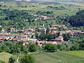
View of Saschiz

View of the Keisder Castle


literature
- Arne Franke: The well-fortified Sachsenland - fortified churches in southern Transylvania. German Cultural Forum for Eastern Europe, Potsdam 2007, ISBN 978-3-936168-27-3 ( online ).
Web links
Individual evidence
- ↑ 2011 census in Romania at citypopulation.de
- ↑ Heinz Heltmann, Gustav Servatius (Ed.): Travel Guide Siebenbürgen. Kraft, Würzburg 1993, ISBN 3-8083-2019-2 .
Acățari | Adămuș | Albeşti | Aluniș | Apold | Ațintiș | Băgaciu | Bahnea | Băla | Bălăușeri | Band | Batoș | Beica de Jos | Bereni | Bichiș | Bogata | Brâncoveneşti | Breaza | Ceuașu de Câmpie | Chețani | Chiheru de Jos | Coroisânmărtin | Corunca | Cozma | Crăciuneşti | Crăiești | Cristești | Cucerdea | Cuci | Daneș | Deda | Hermit | Ernei | Fântânele | Fărăgău | Gălești | Găneşti | Gheorghe Doja | Ghindari | Glodeni | Gorneşti | Grebenișu de Câmpie | Gurghiu | Hodac | Hodoșa | Ibăneşti | Iclănzel | Ideciu de Jos | Livezeni | Lunca | Lunca Bradului | Măgherani | Mica | Miheșu de Câmpie | Nadeș | Neaua | Ogra | Pănet | Papiu Ilarian | Păsăreni | Petelea | Pogăceaua | Râciu | Răstolița | Rușii-Munți | Sâncraiu de Mureș | Sângeorgiu de Mureș | Singer | Sânpaul | Sânpetru de Câmpie | Sântana de Mureș | Saschiz | Sărățeni | Șăulia | Șincai | Solovăstru | Stânceni | Suplac | Suseni | Tăureni | Valea Largă | Vânători | Vărgata | Vătava | Vețca | Viișoara | Voivodeni | Zagăr | Zau de Câmpie
