
Zagar
|
Zagăr Rode Zágor |
|||||
|
|||||
| Basic data | |||||
|---|---|---|---|---|---|
| State : |
|
||||
| Historical region : | Transylvania | ||||
| Circle : | Mureș | ||||
| Coordinates : | 46 ° 21 ' N , 24 ° 37' E | ||||
| Time zone : | EET ( UTC +2) | ||||
| Height : | 349 m | ||||
| Area : | 39.02 km² | ||||
| Residents : | 1,192 (October 20, 2011) | ||||
| Population density : | 31 inhabitants per km² | ||||
| Postal code : | 557200 | ||||
| Telephone code : | (+40) 02 65 | ||||
| License plate : | MS | ||||
| Structure and administration (as of 2016) | |||||
| Community type : | local community | ||||
| Structure : | Zagăr, Seleuș | ||||
| Mayor : | Cornel-Adrian Țânțăreanu ( PNL ) | ||||
| Postal address : | Str. Principală, no. 266 loc. Zagar, jud. Mureș, RO-547655 |
||||
| Website : | |||||


Zagăr ( German Rode , Hungarian Zágor ) is the seat of the municipality of the same name in the Mureș district in the Transylvania region in Romania . The village of Seleuș (Kleinalisch) also belongs to the municipality .
Geographical location

The place is located in a southern side valley of the Târnava Mică (Kleine Kokel) in the Zwischenkokel area, about 20 kilometers as the crow flies northwest of Sighișoara (Schäßburg) and 28 km northeast of Mediaș (Mediasch) . At the Domald - a left tributary of the Târnava Mică - and the county road (drum județean) DJ 142C, the place Zagăr is about 40 kilometers south of the district capital Târgu Mureș (Neumarkt am Mieresch) .
history
Rode, first mentioned in a document in 1412, was one of the northernmost settlements of the Transylvanian Saxons on Kokelburg county floor . Until 1848 the inhabitants were servants of noble Hungarian landowners. However, they enjoyed certain privileges that were guaranteed to them when they settled and that gave them a somewhat easier lot compared to the residents of non-Saxon villages with poor hearing.
In the Kingdom of Hungary , today's municipality belonged to the Erzsébetváros chair district (now Dumbrăveni ) in the Klein-Kokelburg County , then to the historic Târnava-Mică district and, from 1950, to today's Mureş district.
population
The population of the village developed as follows:
| census | Ethnic composition | ||||
|---|---|---|---|---|---|
| year | population | Romanians | Hungary | German | other |
| 1850 | 1,853 | 60 | 6th | 1,727 | 60 |
| 1900 | 2,042 | 295 | 32 | 1,715 | - |
| 1941 | 2,497 | 307 | 10 | 2,058 | 122 |
| 1977 | 1,748 | 622 | 21st | 917 | 188 |
| 2002 | 1,208 | 692 | 45 | 33 | 438 |
| 2011 | 1,192 | 616 | 51 | 17th | 463 |
In 1941 the largest population - at the same time that of the Transylvanian Saxons (1,198 in Zagăr; 860 in Seleuș) - was registered in the municipality. The highest proportion of Romanians (713) was registered in 1956, the Roma (463) and that of the Magyars were registered in 2011. Furthermore, in 2002 a resident declared himself a Serb .
Attractions
- The Protestant church and the village museum

Protestant church

Interior view towards the altar

Inside view towards the organ

In the village museum ...

... the Protestant Church
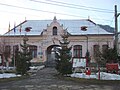
Mayor's office in Zagăr

School for the I. - IV. ...

… V. - VIII. Class
.JPG)
.JPG)
.JPG)
.JPG)
.JPG)
.JPG)
.JPG)
.JPG)
Web links
Individual evidence
- ↑ 2011 census in Romania at citypopulation.de
- ↑ Censuses from 1850 to 2002 in today's Mureș County (PDF; 1.2 MB)
Acățari | Adămuș | Albeşti | Aluniș | Apold | Ațintiș | Băgaciu | Bahnea | Băla | Bălăușeri | Band | Batoș | Beica de Jos | Bereni | Bichiș | Bogata | Brâncoveneşti | Breaza | Ceuașu de Câmpie | Chețani | Chiheru de Jos | Coroisânmărtin | Corunca | Cozma | Crăciuneşti | Crăiești | Cristești | Cucerdea | Cuci | Daneș | Deda | Hermit | Ernei | Fântânele | Fărăgău | Gălești | Găneşti | Gheorghe Doja | Ghindari | Glodeni | Gorneşti | Grebenișu de Câmpie | Gurghiu | Hodac | Hodoșa | Ibăneşti | Iclănzel | Ideciu de Jos | Livezeni | Lunca | Lunca Bradului | Măgherani | Mica | Miheșu de Câmpie | Nadeș | Neaua | Ogra | Pănet | Papiu Ilarian | Păsăreni | Petelea | Pogăceaua | Râciu | Răstolița | Rușii-Munți | Sâncraiu de Mureș | Sângeorgiu de Mureș | Singer | Sânpaul | Sânpetru de Câmpie | Sântana de Mureș | Saschiz | Sărățeni | Șăulia | Șincai | Solovăstru | Stânceni | Suplac | Suseni | Tăureni | Valea Largă | Vânători | Vărgata | Vătava | Vețca | Viișoara | Voivodeni | Zagăr | Zau de Câmpie