
Sânpaul (Mureș)
|
Sânpaul Paulsdorf Kerelőszentpál |
|||||
|
|||||
| Basic data | |||||
|---|---|---|---|---|---|
| State : |
|
||||
| Historical region : | Transylvania | ||||
| Circle : | Mureș | ||||
| Coordinates : | 46 ° 27 ' N , 24 ° 21' E | ||||
| Time zone : | EET ( UTC +2) | ||||
| Height : | 290 m | ||||
| Area : | 55.35 km² | ||||
| Residents : | 4,233 (October 20, 2011) | ||||
| Population density : | 76 inhabitants per km² | ||||
| Postal code : | 547550 | ||||
| Telephone code : | (+40) 02 65 | ||||
| License plate : | MS | ||||
| Structure and administration (as of 2016) | |||||
| Community type : | local community | ||||
| Structure : | Sânpaul, Chirileu , Dileu Nou , Sânmărghita , Valea Izvoarelor | ||||
| Mayor : | István Simon ( UDMR ) | ||||
| Postal address : | Str. Principală, no. 261A loc. Sânpaul, jud. Mureș, RO-547550 |
||||
| Website : | |||||


Sânpaul old spelling Sînpaul [ ˈsɨnpaul ] ( German Paulsdorf or Palesdorf , Hungarian Kerelőszentpál ) is a municipality in the Mureș district in the Transylvania region in Romania .
Geographical location

The municipality of Sânpaul is located in the north of the Kokel Valley (Podișul Târnavelor) in the southwestern part of the Mureș County. On the upper reaches of the Mureș (Mieresch) , the national road DN15 - here part of the European route 60 - and the railway line Alba Iulia – Târgu Mureș , the place Sânpaul is located about halfway between the small towns of Iernut (Radnuten) and Ungheni (Nyarad River) and 21 Kilometers southwest of the district capital Târgu Mureș (Neumarkt am Mieresch) .
The four incorporated villages are about two to six kilometers from the community center.
history
The place Sânpaul was first mentioned in 1332. In 1610 the Hungarian aristocratic Haller family acquired the place and built a country house here. On the area of Sânpauls, called Fântâna Sărată by the locals , a burial site made of stone slabs from the Bronze Age was found in addition to archaeological objects from the Roman to the Neolithic .
Furthermore, it was on the hill Dealul Pietro or Dealul Stanii called a hillside grave assigned to the Bronze Age. Further settlement remnants north of the village on the Homorodul Mare stream indicate that the place was settled . Numerous finds from Roman times from the community center were distributed to several cities in Romania and to Budapest . In the area of Sânpaul, salt was not only extracted in Roman times, but probably since prehistory .
On the Kapellenberg there is a family crypt of the Hungarian aristocratic Haller family .
In the incorporated village of Valea Izvoarelor (Bessen) , at Teleacul Mic , archaeological finds of a settlement dating back to the 1st century BC were found. Chr. And La Măzărişte point in the 4th century, made.
In the Kingdom of Hungary , the incorporated villages of Sânmărghita (Hungarian Mezőszentmargita ) and Dileu Nou (Hungarian Magyardellő ) belonged to the Marosludas ( Luduș ) district in Torda-Aranyos County and the rest of the villages to the Radnót ( Iernut ) district in Klein-Kokelburg County . Subsequently, the villages belonged to the historical districts of Târnava-Mică , Mureş and Odorhei , and from 1950 to the present-day Mureş district.
population
The population of the municipality of Sânpaul developed as follows:
| census | Ethnic composition | ||||
|---|---|---|---|---|---|
| year | population | Romanians | Hungary | German | other |
| 1850 | 2,561 | 1,275 | 1,031 | 1 | 254 |
| 1941 | 3,716 | 1,647 | 1,690 | 7th | 372 |
| 1977 | 4.177 | 1,806 | 1,946 | 4th | 421 |
| 2002 | 4.016 | 1,415 | 1,574 | 2 | 1,025 |
| 2011 | 4.233 | 1,309 | 1,466 | - | 1,458 (Roma 1,308) |
The highest number of inhabitants has been registered in the area of today's municipality since 1850 and that of the Roma in 2011. The highest population of the Magyars (2,044) was determined in 1966, that of the Romanians in 1977 and that of the Romanian Germans (17) in 1900.
Attractions
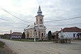
- In the community center, the Roman Catholic Church , built in the 14th century and rebuilt in the 18th, the ruins of the Haller mansion and property, built in the 17th century, and the granary built in the 18th century are listed as historical monuments. Furthermore, a Roman road is assigned to the 2nd or 3rd century.
- In the incorporated village of Chirileu (Laußen) the bust of Vasile Moldovan are under monument protection and a Roman road is noted here.
- In the incorporated village of Dileu Nou the reformed church, built in 1908.
- In the incorporated village of Sânmărghita, the wooden church Sfinții Arhangheli , built in the 18th century, is a listed building.

Roman Catholic Church in Sânpaul
Orthodox Church in Chirileu
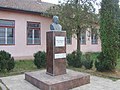
Bust of Vasile Moldovan in Chirileu
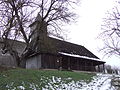
Wooden church in Sânmărghita

.jpg)
.jpg)

personality
- Vasile Moldovan (1824–1895), was a prefect in the legions of the 1848 revolution in Transylvania .
Town twinning
According to a strategic development plan for Sânpaul, the municipality of Sânpaul maintains a partnership with:
-
 Tápiószőlős in the small area of Cegléd in Hungary
Web links
Individual evidence
- ↑ 2011 census in Romania ( MS Excel ; 1.3 MB)
- ↑ Arcanum Kézikönyvtár: Historical-administrative book of place names of Transylvania, Banat and Partium. Retrieved March 30, 2018 (Hungarian).
- ↑ a b Heinz Heltmann, Gustav Servatius (Ed.): Travel Guide Siebenbürgen . Kraft, Würzburg 1993, ISBN 3-8083-2019-2 , p. 517 .
- ↑ Institute Of Archeology - Sanpaul-1 , accessed on April 1, 2018 (Romanian).
- ↑ Institute Of Archeology - Sanpaul-2 , accessed on April 1, 2018 (Romanian).
- ↑ a b c d List of historical monuments of the Romanian Ministry of Culture, updated 2015 (PDF; 12.7 MB; Romanian)
- ↑ Censuses 1850–2002, last updated November 2, 2008 (PDF; 1 MB; Hungarian)
- ↑ Institute Of Archeology - Chirileu , accessed on April 1, 2018 (Romanian).
- ↑ Information on the Reformed Church in Dileu Nou at biserici.org, accessed on March 25, 2018 (Romanian)
- ↑ Marin Căldărariu: COMEMORARE LA Chirileu. cuvantul-liber.ro, April 22, 2015, accessed April 1, 2018 (Romanian).
- ↑ Strategic Development Plan for Sânpaul, 2014–2020. ( PDF ; 1.1 MB) Administraţia Locală Sânpaul; Eurotop Consulting, December 2013, accessed April 1, 2018 (Romanian).
Acățari | Adămuș | Albeşti | Aluniș | Apold | Ațintiș | Băgaciu | Bahnea | Băla | Bălăușeri | Band | Batoș | Beica de Jos | Bereni | Bichiș | Bogata | Brâncoveneşti | Breaza | Ceuașu de Câmpie | Chețani | Chiheru de Jos | Coroisânmărtin | Corunca | Cozma | Crăciuneşti | Crăiești | Cristești | Cucerdea | Cuci | Daneș | Deda | Hermit | Ernei | Fântânele | Fărăgău | Gălești | Găneşti | Gheorghe Doja | Ghindari | Glodeni | Gorneşti | Grebenișu de Câmpie | Gurghiu | Hodac | Hodoșa | Ibăneşti | Iclănzel | Ideciu de Jos | Livezeni | Lunca | Lunca Bradului | Măgherani | Mica | Miheșu de Câmpie | Nadeș | Neaua | Ogra | Pănet | Papiu Ilarian | Păsăreni | Petelea | Pogăceaua | Râciu | Răstolița | Rușii-Munți | Sâncraiu de Mureș | Sângeorgiu de Mureș | Singer | Sânpaul | Sânpetru de Câmpie | Sântana de Mureș | Saschiz | Sărățeni | Șăulia | Șincai | Solovăstru | Stânceni | Suplac | Suseni | Tăureni | Valea Largă | Vânători | Vărgata | Vătava | Vețca | Viișoara | Voivodeni | Zagăr | Zau de Câmpie