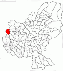
Valea Largă (Mureș)
|
Valea Largă Mezőceked |
||||
|
||||
| Basic data | ||||
|---|---|---|---|---|
| State : |
|
|||
| Historical region : | Transylvania | |||
| Circle : | Mureș | |||
| Coordinates : | 46 ° 37 ' N , 24 ° 4' E | |||
| Time zone : | EET ( UTC +2) | |||
| Height : | 307 m | |||
| Area : | 33.50 km² | |||
| Residents : | 3,098 (October 20, 2011) | |||
| Population density : | 92 inhabitants per km² | |||
| Postal code : | 547615 | |||
| Telephone code : | (+40) 02 65 | |||
| License plate : | MS | |||
| Structure and administration (as of 2016) | ||||
| Community type : | local community | |||
| Structure : | Valea Largă, Grădini , Mălăești , Poduri , Valea Frăției , Valea Glodului , Valea Pădurii , Valea Șurii , Valea Urieșului | |||
| Mayor : | Beniamin Pădurean ( PNL ) | |||
| Postal address : | Str. Principală nr. 248 loc. Valea Largă, jud. Mureș, RO-547615 |
|||
| Website : | ||||
Valea Largă [ ˈvalea ˈlargə ] (outdated Țicud or Cicud ; Hungarian Mezőceked or Ceked ) is a municipality in the Mureș County , in the Transylvania region in Romania .
Geographical location
The municipality of Valea Largă is located in the Transylvanian Heath (Câmpia Transilvaniei) - part of the Transylvanian Basin . In the west of the Mureș district on the Matca brook and the district road (Drum județean) DJ 151C, the town of Valea Largă is located 20 kilometers north of the small town of Luduş (Ludasch) and about 65 kilometers west of the district capital of Târgu Mureş (Neumarkt am Mieresch) .
history
The place Valea Largă was first mentioned in a document in 1279 or 1332, according to different sources. The once Hungarian village was settled by Romanians in the 15th century and belonged to a manor in the village of Luncani (Neusatz) - an incorporated village of today's municipality of Luna (Lone) in the Cluj district .
Archaeological finds on the area of the community center were assigned to the Late Bronze Age .
In a clay hollow , about two and a half kilometers west of the community center, according to the Lista Monumentelor Istorice (register of cultural assets ) in Romania, necropolis is assigned to the 7th century.
In the Kingdom of Hungary , the places of today's municipality belonged to the Marosludas chair district in the Torda-Aranyos County , then to the historical Turda district and from 1950 to the present Mureș district.
A large part of the drinking water network was set up in the municipality in 2018 .
population
The population of the municipality of Valea Largă developed as follows:
| census | Ethnic composition | ||||
|---|---|---|---|---|---|
| year | population | Romanians | Hungary | German | other |
| 1850 | 1,461 | 1,376 | - | - | 85 |
| 1910 | 2,396 | 2,246 | 19th | 6th | 125 |
| 1977 | 4.158 | 4,093 | 10 | - | 55 |
| 2002 | 3,379 | 3,303 | 9 | 1 | 66 |
| 2011 | 3,098 | 2,963 | 13 | - | 122 |
Since 1850, the highest number of inhabitants and that of Romanians in 1977 were determined in the area of today's municipality. The highest number of Magyars (32) was registered in 1890, that of Roma (140) in 2011 and that of Romanian Germans in 1910.
Attractions
- Apart from the wooden church Adormirea Maicii Domnului in the community center, painted in 1733, there are no noteworthy sights to mention.
Web links
Individual evidence
- ↑ 2011 census in Romania ( MS Excel ; 1.3 MB)
- ↑ a b Heinz Heltmann, Gustav Servatius (Ed.): Travel Guide Siebenbürgen . Kraft, Würzburg 1993, ISBN 3-8083-2019-2 , p. 517 .
- ↑ Information on the municipality's website , accessed on May 23, 2019 (Romanian).
- ^ Institute Of Archeology - Valea Largă , accessed May 23, 2019 (Romanian).
- ↑ List of historical monuments of the Romanian Ministry of Culture, updated 2015 (PDF; 12.7 MB; Romanian).
- ^ Protocol. (PDF; 1.3 MB) Retrieved May 23, 2019 (Romanian).
- ↑ Censuses 1850–2002, last updated November 2, 2008 (PDF; 1 MB; Hungarian).
- ↑ Information on the wooden church in Valea Largă at biserici.org, accessed on May 23, 2019 (Romanian).


