
Ogra
|
Ogra Ugern Marosugra |
|||||
|
|||||
| Basic data | |||||
|---|---|---|---|---|---|
| State : |
|
||||
| Historical region : | Transylvania | ||||
| Circle : | Mureș | ||||
| Coordinates : | 46 ° 27 ' N , 24 ° 19' E | ||||
| Time zone : | EET ( UTC +2) | ||||
| Height : | 329 m | ||||
| Area : | 52.16 km² | ||||
| Residents : | 2,387 (October 20, 2011) | ||||
| Population density : | 46 inhabitants per km² | ||||
| Postal code : | 547440 | ||||
| Telephone code : | (+40) 02 65 | ||||
| License plate : | MS | ||||
| Structure and administration (as of 2016) | |||||
| Community type : | local community | ||||
| Structure : | Ogra, Dileu Vechi , Giuluș , Lăscud , Vaideiu | ||||
| Mayor : | Marian Palaghie ( PNL ) | ||||
| Postal address : | Str. Principală, no. 103A loc. Ogra, jud. Mureș, RO-547440 |
||||
| Website : | |||||


Ogra ( German Ugern , Hungarian Marosugra or Ugra ) is a municipality in the Mureș district , in the Transylvania region in Romania .
Geographical location

The municipality of Ogra is located in the north of the Kokel Valley (Podișul Târnavelor) in the southwestern part of the Mureș County. On the upper reaches of the Mureș (Mieresch) , the national road DN15 - here part of the European route 60 - and the railway line Alba Iulia – Târgu Mureș , the place Ogra is located six kilometers east of the city of Iernut (Radnuten) and 24 kilometers southwest of the district capital Târgu Mureș (Neumarkt am Mieresch) away.
The four incorporated villages are located about four to eight kilometers from the community center.
history
The place Ogra was first mentioned in 1367. In the Middle Ages, Orga belonged to the estate of what is now Sânpaul, two kilometers away . In 1803 the Hungarian aristocratic Haller family acquired market rights for the place and built a country house here.
Except for a few archaeological finds of the Hallstatt period which, according to JF Niegebauer and M. Roska the Scythians were assigned, is located between a Roman road and the Mures a hillside grave , which was not yet assigned to age.
In the Kingdom of Hungary , today's municipality belonged partly to the Radnót ( Iernut ) district in Klein-Kokelburg County ; the incorporated villages of Dileu Vechi (Hungarian Oláhdellő ) and Vaideiu (Neudorf) to the Marosludas ( Luduș ) district in Torda-Aranyos County . Subsequently, the villages belonged to the historical district of Târnava-Mică or Mureş and from 1950 to today's Mureş district.
In the autumn of 1944, heavy fighting between German and Soviet and Romanian troops took place in the area of the municipality on Mureș.
population
The population of the municipality of Ogra developed as follows:
| census | Ethnic composition | ||||
|---|---|---|---|---|---|
| year | population | Romanians | Hungary | German | other |
| 1850 | 2,930 | 2,166 | 531 | - | 233 |
| 1941 | 4.134 | 2,692 | 1,207 | 4th | 231 |
| 1966 | 3,535 | 2.131 | 1,135 | 4th | 265 |
| 2002 | 2,441 | 1,266 | 634 | 3 | 538 |
| 2011 | 2,387 | 1,081 | 508 | 3 | 795 (Roma 697) |
The highest number of inhabitants has been registered in the area of today's municipality since 1850 and that of the Romanians in 1941. The highest population of the Magyars (1,406) was determined in 1930, that of the Romanian Germans in 1941 and 1966 and that of the Roma (697) in 2011.
Attractions
- In the community center the Haller mansion , built in the 17th century, is a listed building, and the reformed church .
- The Reformed Church in the incorporated village of Dileu Vechi, built in 1908.
- In the incorporated village of Vaideiu, the wooden church Sfinții Arhangheli , built in 1866 and renovated in 1899, burned on December 6, 2017, but could be extinguished in time.
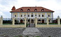
Haller mansion
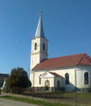
Reformed Church in Ogra

Reformed Church in Dileu Vechi

Orthodox Church in Dileu Vechi

Wooden church in Vaideiu
.JPG)

.jpg)
.jpg)

personality
- Gheorghe Guțiu (1924-2011), was a Romanian Greek Catholic bishop in the Diocese of Cluj-Gherla .
Web links
Individual evidence
- ↑ 2011 census in Romania ( MS Excel ; 1.3 MB)
- ↑ Arcanum Kézikönyvtár: Historical-administrative book of place names of Transylvania, Banat and Partium. Retrieved March 25, 2018 (Hungarian).
- ↑ a b Heinz Heltmann, Gustav Servatius (Ed.): Travel Guide Siebenbürgen . Kraft, Würzburg 1993, ISBN 3-8083-2019-2 , p. 517 .
- ↑ Institute Of Archeology - Ogra , accessed on March 25, 2018 (Romanian).
- ↑ Censuses 1850–2002, last updated November 2, 2008 (PDF; 1 MB; Hungarian)
- ↑ Web presentation of Haller Castle , accessed on March 25, 2018 (multilingual).
- ↑ List of historical monuments of the Romanian Ministry of Culture, updated 2015 (PDF; 12.7 MB; Romanian)
- ↑ Information on the Reformed Church in Dileu Vechi at biserici.org, accessed on March 25, 2018 (Romanian)
- ↑ A church from the 17th century in Mureș County was rescued by the locals , accessed on December 6, 2017 from observator.tv on March 25, 2018 (Romanian)
Acățari | Adămuș | Albeşti | Aluniș | Apold | Ațintiș | Băgaciu | Bahnea | Băla | Bălăușeri | Band | Batoș | Beica de Jos | Bereni | Bichiș | Bogata | Brâncoveneşti | Breaza | Ceuașu de Câmpie | Chețani | Chiheru de Jos | Coroisânmărtin | Corunca | Cozma | Crăciuneşti | Crăiești | Cristești | Cucerdea | Cuci | Daneș | Deda | Hermit | Ernei | Fântânele | Fărăgău | Gălești | Găneşti | Gheorghe Doja | Ghindari | Glodeni | Gorneşti | Grebenișu de Câmpie | Gurghiu | Hodac | Hodoșa | Ibăneşti | Iclănzel | Ideciu de Jos | Livezeni | Lunca | Lunca Bradului | Măgherani | Mica | Miheșu de Câmpie | Nadeș | Neaua | Ogra | Pănet | Papiu Ilarian | Păsăreni | Petelea | Pogăceaua | Râciu | Răstolița | Rușii-Munți | Sâncraiu de Mureș | Sângeorgiu de Mureș | Singer | Sânpaul | Sânpetru de Câmpie | Sântana de Mureș | Saschiz | Sărățeni | Șăulia | Șincai | Solovăstru | Stânceni | Suplac | Suseni | Tăureni | Valea Largă | Vânători | Vărgata | Vătava | Vețca | Viișoara | Voivodeni | Zagăr | Zau de Câmpie