
Gheorghe Doja (Mureș)
|
Gheorghe Doja Dózsa György |
|||||
|
|||||
| Basic data | |||||
|---|---|---|---|---|---|
| State : |
|
||||
| Historical region : | Transylvania | ||||
| Circle : | Mureș | ||||
| Coordinates : | 46 ° 28 ' N , 24 ° 30' E | ||||
| Time zone : | EET ( UTC +2) | ||||
| Height : | 303 m | ||||
| Area : | 37.45 km² | ||||
| Residents : | 2,982 (October 20, 2011) | ||||
| Population density : | 80 inhabitants per km² | ||||
| Postal code : | 547260 | ||||
| Telephone code : | (+40) 02 65 | ||||
| License plate : | MS | ||||
| Structure and administration (as of 2016) | |||||
| Community type : | local community | ||||
| Structure : | Gheorghe Doja, Ilieni , Leordeni , Satu Nou , Tirimia | ||||
| Mayor : | Tibor Iszlai ( UDMR ) | ||||
| Postal address : | Str. Principală, no. 6 loc. Gheorghe Doja, jud. Mureș, RO-547260 |
||||
| Website : | |||||


Gheorghe Doja [ ˈɟeorɟe ˈdoʒa ] (outdated Lucafalău ; Hungarian Dózsa György or Lukafalva ) is a municipality in Mureș County , in the Transylvania region in Romania .
Geographical location

The municipality of Gheorghe Doja is located north of the Kokel Valley (Podișul Târnavelor) in the southern part of the Mureș district in the so-called Țara Morcovilor (carrot country) . On the Niraj , a left tributary of the Mureș (Mieresch) and the district road (Drum județean) DJ 151D, the place Gheorghe Doja is seven kilometers east of the small town of Ungheni (Nyarad River) and 16 kilometers south of the district capital Târgu Mureș (Neumarkt am Mieresch) away. The incorporated villages are about one to four kilometers away from the community center.
Until around 2010, a narrow-gauge railway of the original narrow-gauge line from Cristeşti to Sovata (Szováta) operated on the area of the municipality .
history
The place Gheorghe Doja, founded by Szekler , was first mentioned in a document in 1331 or 1333, according to various sources.
On the grounds of the unincorporated village Tirimia , at the foot of the mountain Porumbelul (Hungarian Galambhegy ) were archaeological finds were assigned to anyone yet age found.
In the Kingdom of Hungary , today's municipality belonged to the Maros alsó ("Unter-Maros") district in Maros-Torda County , then to the historical Mureș County and, from 1950, today's Mureș County.
population
The population of the municipality of Gheorghe Doja developed as follows:
| census | Ethnic composition | ||||
|---|---|---|---|---|---|
| year | population | Romanians | Hungary | German | other |
| 1850 | 3,054 | 843 | 2,048 | 3 | 160 |
| 1941 | 3.823 | 851 | 2,963 | - | 9 |
| 2002 | 2,869 | 611 | 2,068 | - | 190 |
| 2011 | 2,982 | 617 | 2,169 | - | 196 |
The highest number of inhabitants has been registered in the area of today's municipality since 1850 and that of the Magyars in 1941. The highest population of Romanians (1,190) was determined in 1920, that of Roma (188) in 2002 and that of Romanian Germans (24) in 1880.
Attractions
- In the community center the reformed church , built in 1750. Its wooden bell tower was replaced by the stone tower in 1781.
- In the incorporated village of Leordeni (Lörinzdorf) the reformed church, built around 1815, is a listed building. Furthermore, a Roman road is noted on the site of the village . The locals call it Calea Dracului (Ördögutja) (Devil's Way ).
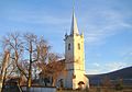
Reformed Church in Gheorghe Doja

Reformed Church in Leordeni
.jpg)
.JPG)
Web links
Individual evidence
- ↑ 2011 census in Romania ( MS Excel ; 1.3 MB)
- ↑ Trecerile la nivel cu soseaua E60 din Ungheni si Acatari au fost desfiintate at transira.ro, accessed on February 12, 2018 (Romanian)
- ↑ Information on the website of the municipality of Gheorghe Doja , accessed on April 15, 2018 (Romanian).
- ↑ a b Heinz Heltmann, Gustav Servatius (Ed.): Travel Guide Siebenbürgen . Kraft, Würzburg 1993, ISBN 3-8083-2019-2 , p. 517 .
- ↑ Institute Of Archeology - Tirimia , accessed on April 15, 2018 (Romanian).
- ↑ Censuses 1850–2002, last updated November 2, 2008 (PDF; 1 MB; Hungarian)
- ↑ Information on the Reformed Church in Leordeni at biserici.org, accessed on April 15, 2018 (Romanian)
- ↑ List of historical monuments of the Romanian Ministry of Culture, updated 2015 (PDF; 12.7 MB; Romanian)
- ^ Institute Of Archeology - Leordeni , accessed April 15, 2018 (Romanian).
Acățari | Adămuș | Albeşti | Aluniș | Apold | Ațintiș | Băgaciu | Bahnea | Băla | Bălăușeri | Band | Batoș | Beica de Jos | Bereni | Bichiș | Bogata | Brâncoveneşti | Breaza | Ceuașu de Câmpie | Chețani | Chiheru de Jos | Coroisânmărtin | Corunca | Cozma | Crăciuneşti | Crăiești | Cristești | Cucerdea | Cuci | Daneș | Deda | Hermit | Ernei | Fântânele | Fărăgău | Gălești | Găneşti | Gheorghe Doja | Ghindari | Glodeni | Gorneşti | Grebenișu de Câmpie | Gurghiu | Hodac | Hodoșa | Ibăneşti | Iclănzel | Ideciu de Jos | Livezeni | Lunca | Lunca Bradului | Măgherani | Mica | Miheșu de Câmpie | Nadeș | Neaua | Ogra | Pănet | Papiu Ilarian | Păsăreni | Petelea | Pogăceaua | Râciu | Răstolița | Rușii-Munți | Sâncraiu de Mureș | Sângeorgiu de Mureș | Singer | Sânpaul | Sânpetru de Câmpie | Sântana de Mureș | Saschiz | Sărățeni | Șăulia | Șincai | Solovăstru | Stânceni | Suplac | Suseni | Tăureni | Valea Largă | Vânători | Vărgata | Vătava | Vețca | Viișoara | Voivodeni | Zagăr | Zau de Câmpie