
Ceuaşu de Câmpie
|
Ceuaşu de Campie pit village Mezőcsávás |
|||||
|
|||||
| Basic data | |||||
|---|---|---|---|---|---|
| State : |
|
||||
| Historical region : | Transylvania | ||||
| Circle : | Mureș | ||||
| Coordinates : | 46 ° 38 ' N , 24 ° 31' E | ||||
| Time zone : | EET ( UTC +2) | ||||
| Height : | 375 m | ||||
| Area : | 83.38 km² | ||||
| Residents : | 5,964 (October 20, 2011) | ||||
| Population density : | 72 inhabitants per km² | ||||
| Postal code : | 547140 | ||||
| Telephone code : | (+40) 02 65 | ||||
| License plate : | MS | ||||
| Structure and administration (as of 2016) | |||||
| Community type : | local community | ||||
| Structure : | Ceuașu de Câmpie, Bozed , Câmpenița , Culpiu , Herghelia , Porumbeni , Săbed , Voiniceni | ||||
| Mayor : | Jozsef-Levente Szabo ( UDMR ) | ||||
| Postal address : | Str. Principală, no. 365 loc. Ceuașu de Câmpie, jud. Mureș, RO-547140 |
||||
| Website : | |||||


Ceuașu de Câmpie old spelling Ceuașu de Cîmpie [ ˈt͡ʃeuaʃu de kɨmpie ] (outdated Ciavașul de Câmpie or Ceovaș ; German Grubendorf , Hungarian Mezőcsávás ) is a municipality in the Mureș County , in the Transylvania region in Romania .
The place is also known under the Hungarian name Csávás .
Geographical location

The municipality of Ceuașu de Câmpie is located in the Mureș Valley in the Transylvanian Basin north of the Kokel Highlands (Podișul Târnavelor) in the center of the Mureș District. On the Voiniceni brook - a right tributary of the Mureș (Mieresch) - and the national road 15E , the place Ceuașu de Câmpie is located 12 kilometers north of the district capital Târgu Mureș (Neumarkt am Mieresch) .
history
The place Ceuaşu de Câmpie founded by Szekler was first mentioned in 1505. After 1660, many Romanians also settled here. Archaeological finds on the area of the place, called Dâmbu Rotund (Hungarian Kerekdomb ) by the locals , however, indicate settlement as far back as the Latène period .
The remains of a castle in the area of the incorporated village of Herghelia (Mezőménes) have not yet been assigned to any era. Numerous archaeological finds in the area of the incorporated village of Săbed (Szabéd) have been dated to different ages, a settlement in the incorporated village of Voiniceni (Mezőszabad) is assigned to Roman times .
In the Kingdom of Hungary , the municipality belonged to the Maros Felső (Ober-Maros) district in Maros-Torda County and then to the historical Mureș District and, from 1950, today's Mureș District.
population
The population of the municipality of Ceuașu de Câmpie developed as follows:
| census | Ethnic composition | ||||
|---|---|---|---|---|---|
| year | population | Romanians | Hungary | German | other |
| 1850 | 4,731 | 1,901 | 2,498 | 1 | 331 |
| 1920 | 5,453 | 2,502 | 2,944 | 3 | 4th |
| 1941 | 6,494 | 2,514 | 3.811 | - | 169 |
| 2002 | 5,419 | 2,222 | 2,675 | 1 | 521 |
| 2011 | 5,964 | 2,547 | 2,624 | - | 793 |
Since 1850 the area of today's municipality had the highest number of inhabitants and at the same time that of the Magyars in 1941. The highest number of Romanians (2,913) was recorded in 1966, that of Roma (616) in 2011 and that of Romanian Germans (21) in 1900.
Attractions
- In Ceuașu de Câmpie, the reformed church built at the end of the 18th century and the wooden bell tower built in 1570 are listed.
- In the incorporated village of Bozed (Hungarian Bazéd ) the wooden church Sfinții Arhangheli Mihail și Gavriil , built in 1750, is a listed building.
- In the incorporated village of Culpiu ( Mezőkölpény in Hungarian ) the bell tower of the reformed church built in the 19th century and the wooden church Sfinții Arhangheli Mihail și Gavriil also built in the 19th century are under monument protection.
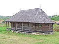
- In the incorporated village of Porumbeni ( Galambod in Hungarian ) the wooden church Sfântul Ioan Botezătorul , built in 1749, is a listed building.
- On the area of the village of Săbed, the nature reserve Pădurea Săbed , according to various sources, 59 hectares or 64.69 hectares in size.

Wooden church in Bozed
Wooden church in Culpiu

Bell tower of the reformed church in Culpiu

Wooden church in Porumbeni

Reformed Church in Ceuașu de Câmpie


.jpg)


Personalities
- Dezső Balogh (1930–1999), born in Ceuașu de Câmpie, was a linguist and book author
- Ödön Nagy (1914–1995), buried in Câmpenița (Hungarian Mezőfele ), was a clergyman and ethnographer and has recorded numerous traditions of the village population, their folk customs and village traditions in connection with church holidays.
Web links
Individual evidence
- ↑ 2011 census in Romania ( MS Excel ; 1.3 MB)
- ↑ Arcanum Kézikönyvtár: Historical-administrative book of place names of Transylvania, Banat and Partium. Retrieved November 4, 2018 (Hungarian).
- ↑ Heinz Heltmann, Gustav Servatius (Ed.): Travel Guide Siebenbürgen . Kraft, Würzburg 1993, ISBN 3-8083-2019-2 , p. 517 .
- ↑ Institute Of Archeology - Ceuaşu de Campie , accessed on November 5, 2018 (Romanian).
- ↑ Institute Of Archeology - Herghelia , accessed on November 5, 2018 (Romanian).
- ↑ Institute Of Archeology - Săbed , accessed on November 5, 2018 (Romanian).
- ↑ a b c d e List of historical monuments of the Romanian Ministry of Culture, updated 2015 (PDF; 12.7 MB; Romanian)
- ↑ Censuses 1850–2002, last updated November 2, 2008 (PDF; 1 MB; Hungarian)
- ↑ Information on the Reformed Church in Ceuașu de Câmpie at biserici.org, accessed on November 6, 2018 (Romanian)
- ↑ Information on the wooden church in Bozed at biserici.org, accessed on November 6, 2018 (Romanian)
- ↑ Information on the wooden church in Culpiu at biserici.org, accessed on November 6, 2018 (Romanian)
- ↑ Parlamentul României: Law No. 5. M.Of. No. 152, April 12, 2000, accessed November 6, 2018 (Romanian).
- ^ European Environment Agency: Pădurea Săbed. eunis.eea.europa.eu, 1977, accessed on November 6, 2018 (English).
- ↑ The historical chronology of the Hungarian minority in Romania 1990–2009: Information on Dezső Balogh. Retrieved November 6, 2018 (Hungarian).
- ↑ Information on Ödön Nagy from mek.oszk.hu accessed on September 27, 2019 (Hungarian).
Acățari | Adămuș | Albeşti | Aluniș | Apold | Ațintiș | Băgaciu | Bahnea | Băla | Bălăușeri | Band | Batoș | Beica de Jos | Bereni | Bichiș | Bogata | Brâncoveneşti | Breaza | Ceuașu de Câmpie | Chețani | Chiheru de Jos | Coroisânmărtin | Corunca | Cozma | Crăciuneşti | Crăiești | Cristești | Cucerdea | Cuci | Daneș | Deda | Hermit | Ernei | Fântânele | Fărăgău | Gălești | Găneşti | Gheorghe Doja | Ghindari | Glodeni | Gorneşti | Grebenișu de Câmpie | Gurghiu | Hodac | Hodoșa | Ibăneşti | Iclănzel | Ideciu de Jos | Livezeni | Lunca | Lunca Bradului | Măgherani | Mica | Miheșu de Câmpie | Nadeș | Neaua | Ogra | Pănet | Papiu Ilarian | Păsăreni | Petelea | Pogăceaua | Râciu | Răstolița | Rușii-Munți | Sâncraiu de Mureș | Sângeorgiu de Mureș | Singer | Sânpaul | Sânpetru de Câmpie | Sântana de Mureș | Saschiz | Sărățeni | Șăulia | Șincai | Solovăstru | Stânceni | Suplac | Suseni | Tăureni | Valea Largă | Vânători | Vărgata | Vătava | Vețca | Viișoara | Voivodeni | Zagăr | Zau de Câmpie