
Glodeni (Mureș)
|
Glodeni Scharpendorf Marossárpatak |
|||||
|
|||||
| Basic data | |||||
|---|---|---|---|---|---|
| State : |
|
||||
| Historical region : | Transylvania | ||||
| Circle : | Mureș | ||||
| Coordinates : | 46 ° 39 ' N , 24 ° 37' E | ||||
| Time zone : | EET ( UTC +2) | ||||
| Height : | 367 m | ||||
| Area : | 54.39 km² | ||||
| Residents : | 3,817 (October 20, 2011) | ||||
| Population density : | 70 inhabitants per km² | ||||
| Postal code : | 547275 | ||||
| Telephone code : | (+40) 02 65 | ||||
| License plate : | MS | ||||
| Structure and administration (as of 2016) | |||||
| Community type : | local community | ||||
| Structure : | Glodeni, Merișor , Moișa , Păcureni , Păingeni | ||||
| Mayor : | Barna Kozma ( UDMR ) | ||||
| Postal address : | Str. Principală, no. 133 loc. Glodeni, jud. Mureș, RO-547275 |
||||
| Website : | |||||


Glodeni [ gloˈdenʲ ] (outdated Șarpotoc ; German Scharpendorf , Hungarian Marossárpatak ) is a municipality in the district of Mureș , in the Transylvania region in Romania .
The place is also known by the German names Kothbach and Schellenberg and the Hungarian Sárpatak .
Geographical location

The municipality of Glodeni is located in the Mureș Valley in the Transylvanian Basin north of the Kokel Highlands (Podișul Târnavelor) in the center of the Mureș County. At the mouth of the Șar brook - a right tributary of the Mureș (Mieresch) - and the district road (drum județean) DJ 135B, Glodeni is 17 kilometers north of the district capital of Târgu Mureș (Neumarkt am Mieresch) .
history
The place Glodeni was first mentioned in 1268. A Roman road and archaeological finds from the Bronze Age are noted on the site . In the Middle Ages the place was owned by the Hungarian noble family Bánffy and later by the Teleki family .
There is also a Roman road in the area of the incorporated village of Păingeni (Pokendorf) and remains of Roman buildings are noted.
In the Kingdom of Hungary , the municipality belonged to the Maros Felső (Ober-Maros) district in Maros-Torda County and then to the historical Mureș District and, from 1950, today's Mureș District.
population
The population of the municipality of Glodeni developed as follows:
| census | Ethnic composition | ||||
|---|---|---|---|---|---|
| year | population | Romanians | Hungary | German | other |
| 1850 | 2,819 | 1,088 | 1,489 | 5 | 237 |
| 1930 | 3,790 | 1,525 | 2,040 | 4th | 221 |
| 1966 | 4,674 | 1,490 | 3,030 | 1 | 153 |
| 2002 | 3,822 | 810 | 2,892 | - | 120 |
| 2011 | 3.817 | 697 | 2,587 | - | 533 |
Since 1850, the highest number of inhabitants was registered in the area of today's municipality in 1966. The highest number of Magyars (3,057) was recorded in 1977, that of Romanians (1,548) in 1956, that of Roma (438) in 2011 and that of Romanian Germans (17) in 1920.
Attractions
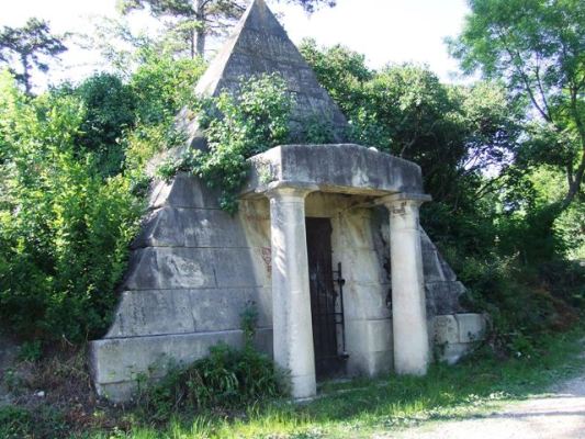
- In Glodeni, the wooden church Sfinții Arhangheli Mihail și Gavriil , built in the 17th century and the Teleki manor , according to various sources, between 1770 and 1803 or 1872 and the crypt of the Teleki family built in 1802 are listed.
- In the incorporated village of Moișa (Hungarian Mezőmajos ) the wooden church Sf. Arhangheli , built in 1752, is a listed building.
- In the incorporated village of Păcureni (Hungarian Pókakeresztúr ) the reformed church , built according to various statements in the 13th or 15th century, renewed at the beginning of the 20th and the wooden church Sfinții Arhangheli Mihail și Gavriil , built in the 17th or 18th century under monument conservation.
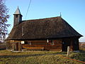
Wooden church in Glodeni

Teleki Manor

Wooden church in Moișa

Reformed Church in Păcureni

Wooden church in Păcureni

.jpg)

.jpg)

Personalities
- Tavaszy Sándor (1888–1951), born in Marossárpatak , was a philosopher, writer, and theology teacher
Web links
Individual evidence
- ↑ 2011 census in Romania ( MS Excel ; 1.3 MB)
- ↑ Arcanum Kézikönyvtár: Historical-administrative book of place names of Transylvania, Banat and Partium. Retrieved October 30, 2018 (Hungarian).
- ↑ a b Heinz Heltmann, Gustav Servatius (Ed.): Travel Guide Siebenbürgen . Kraft, Würzburg 1993, ISBN 3-8083-2019-2 , p. 517 .
- ^ Institute Of Archeology - Glodeni , accessed November 1, 2018 (Romanian).
- ↑ Institute Of Archeology - Păingeni , accessed on November 1, 2018 (Romanian).
- ↑ Censuses 1850–2002, last updated November 2, 2008 (PDF; 1 MB; Hungarian)
- ↑ Information on the wooden church in Glodeni at biserici.org, accessed on November 1, 2018 (Romanian)
- ↑ picture of Guft the family Teleki in Glodeni
- ↑ a b c List of historical monuments of the Romanian Ministry of Culture, updated 2015 (PDF; 12.7 MB; Romanian)
- ↑ Information on the Reformed Church in Păcureni at biserici.org, accessed on November 1, 2018 (Romanian)
- ↑ Information on the wooden church in Păcureni at biserici.org, accessed on November 1, 2018 (Romanian)
- ↑ A Kolozsvár Iskola. ( PDF ; 1.4 MB) Retrieved November 1, 2018 (Hungarian).
Acățari | Adămuș | Albeşti | Aluniș | Apold | Ațintiș | Băgaciu | Bahnea | Băla | Bălăușeri | Band | Batoș | Beica de Jos | Bereni | Bichiș | Bogata | Brâncoveneşti | Breaza | Ceuașu de Câmpie | Chețani | Chiheru de Jos | Coroisânmărtin | Corunca | Cozma | Crăciuneşti | Crăiești | Cristești | Cucerdea | Cuci | Daneș | Deda | Hermit | Ernei | Fântânele | Fărăgău | Gălești | Găneşti | Gheorghe Doja | Ghindari | Glodeni | Gorneşti | Grebenișu de Câmpie | Gurghiu | Hodac | Hodoșa | Ibăneşti | Iclănzel | Ideciu de Jos | Livezeni | Lunca | Lunca Bradului | Măgherani | Mica | Miheșu de Câmpie | Nadeș | Neaua | Ogra | Pănet | Papiu Ilarian | Păsăreni | Petelea | Pogăceaua | Râciu | Răstolița | Rușii-Munți | Sâncraiu de Mureș | Sângeorgiu de Mureș | Singer | Sânpaul | Sânpetru de Câmpie | Sântana de Mureș | Saschiz | Sărățeni | Șăulia | Șincai | Solovăstru | Stânceni | Suplac | Suseni | Tăureni | Valea Largă | Vânători | Vărgata | Vătava | Vețca | Viișoara | Voivodeni | Zagăr | Zau de Câmpie