Pogăceaua
|
Pogăceaua Mezőpagocsa |
||||
|
||||
| Basic data | ||||
|---|---|---|---|---|
| State : |
|
|||
| Historical region : | Transylvania | |||
| Circle : | Mureș | |||
| Coordinates : | 46 ° 41 ′ N , 24 ° 19 ′ E | |||
| Time zone : | EET ( UTC +2) | |||
| Height : | 355 m | |||
| Area : | 37.97 km² | |||
| Residents : | 2,117 (October 20, 2011) | |||
| Population density : | 56 inhabitants per km² | |||
| Postal code : | 547465 | |||
| Telephone code : | (+40) 02 65 | |||
| License plate : | MS | |||
| Structure and administration (as of 2016) | ||||
| Community type : | local community | |||
| Structure : | Pogăceaua, Bologaia , Ciulea , Deleni , Fântâna Babii , Pârâu Crucii , Scurta , Sicele , Valea Sânpetrului , Văleni | |||
| Mayor : | Viorel Șuteu ( PNL ) | |||
| Postal address : | Str. Primăriei nr. 152 loc. Pogăceaua, jud. Mureș, RO-547465 |
|||
| Website : | ||||
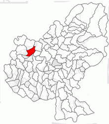
Pogăceaua [ pogəˈt͡ʃeaua ] ( Hungarian Mezőpagocsa or Pagocsa ) is a municipality in the Mureș County , in the Transylvania region in Romania .
Geographical location
The municipality of Pogăceaua is located in the Transylvanian Heath (Câmpia Transilvaniei) - part of the Transylvanian Basin - in the west of the Mureș County. On the upper reaches of the Bologa and the district road (drum județean) DJ 152B, the place Pogăceaua is about 36 kilometers northwest of the district capital Târgu Mureș (Neumarkt am Mieresch) .
The incorporated villages and hamlets of the community are located one to six kilometers from the community center. Of the approximately 3800 hectares of the municipal area, about 2500 hectares are arable land and 30 hectares are orchards and vineyards .
history
The place Pogăceaua was first mentioned in 1345 and was a Romanian Knesendorf in the Middle Ages .
Settlement of the municipal area is dated in the area of the incorporated village Deleni (Hungarian Ökröstó ) in the Bronze Age and near Văleni , on the mountain called Dealul Belvány by the locals , in the Neolithic and in Pădurea Rotundă in the Copper Age.
In the Kingdom of Hungary , the place belonged to the Maros Felső ("Ober-Maros") district in the Maros-Torda County, then to the historical Mureș County and, from 1950, to today's Mureș County.
A narrow-gauge railway once ran on the area of the municipality between Târgu Mureș via Band (Bandorf) to Șăulia (Hungarian Mezősályi ).
population
The population of the municipality of Pogăceaua developed as follows:
| census | Ethnic composition | ||||
|---|---|---|---|---|---|
| year | population | Romanians | Hungary | German | other |
| 1850 | 1,470 | 1,208 | 117 | 1 | 144 |
| 1941 | 2,843 | 2,536 | 231 | 3 | 73 |
| 1966 | 3.128 | 2,861 | 153 | - | 114 |
| 2002 | 1,983 | 1,765 | 26th | - | 192 |
| 2011 | 2.117 | 1,740 | 27 | - | 350 |
Since 1850, the highest number of inhabitants and that of Romanians in 1966 have been registered in the area of today's municipality. The highest number of Magyars (321) was recorded in 1910, Roma (320) in 2011 and that of Romanian Germans in 1941.
Attractions
Apart from the reservoir ( ⊙ ) southwest of the incorporated village of Văleni, there are no noteworthy sights in the municipality of Pogăceaua.
Web links
Individual evidence
- ↑ 2011 census in Romania ( MS Excel ; 1.3 MB)
- ↑ Heinz Heltmann, Gustav Servatius (Ed.): Travel Guide Siebenbürgen . Kraft, Würzburg 1993, ISBN 3-8083-2019-2 , p. 517 .
- ↑ Information on Văleni from Repertoriul Arheologic Național (RAN), accessed on January 9, 2019 (Romanian)
- ↑ Information on the municipality of Pogăceaua from primariapogaceaua.ro accessed on January 9, 2019 (Romanian)
- ↑ Censuses 1850–2002, last updated November 2, 2008 (PDF; 1 MB; Hungarian)
- ↑ View of the lake at Văleni


