Sângeorgiu de Mureș
|
Sângeorgiu de Mureș Marosszentgyörgy |
||||
|
||||
| Basic data | ||||
|---|---|---|---|---|
| State : |
|
|||
| Historical region : | Transylvania | |||
| Circle : | Mureș | |||
| Coordinates : | 46 ° 35 ′ N , 24 ° 36 ′ E | |||
| Time zone : | EET ( UTC +2) | |||
| Height : | 350 m | |||
| Area : | 28.96 km² | |||
| Residents : | 9,304 (October 20, 2011) | |||
| Population density : | 321 inhabitants per km² | |||
| Postal code : | 547530 | |||
| Telephone code : | (+40) 02 65 | |||
| License plate : | MS | |||
| Structure and administration (as of 2016) | ||||
| Community type : | local community | |||
| Structure : | Sângeorgiu de Mureș, Cotuș , Tofalău | |||
| Mayor : | Sándor-Szabolcs Sófalvi ( UDMR ) | |||
| Postal address : | Petki Dávid street, no. 130 loc. Sângeorgiu de Mureș, jud. Mureș, RO-547530 |
|||
| Others | ||||
| City Festival : | annually in April, the community festival Zilele Sângeorzene | |||
Sângeorgiu de Mureș old spelling Sîngeorgiu de Mureș [ sɨnˈd͡ʒeord͡ʒiu de mureʃ ] (outdated Sângeorzul de Murăș ; Hungarian Marosszentgyörgy ) is a municipality in the Mureș County , in the Transylvania region in Romania .
The place is also known by the Hungarian names Szentgyörgy and Cigányszentgyörgy .
Geographical location
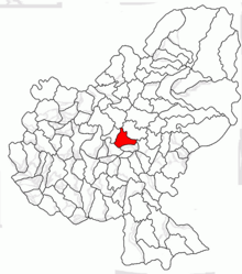
The municipality of Sângeorgiu de Mureș is located in the Mureș Valley in the Transylvanian Basin north of the Kokel Highlands (Podișul Târnavelor) . Sângeorgiu de Mureş is located in the center of the Mureş district at Drum național 15 , about 5 kilometers northeast of the district capital Târgu Mureş (Neumarkt am Mieresch) . The Târgu Mureș – Deda – Gheorgheni railway runs in the area of the municipality, but has no railway station here.
history
The place Sângeorgiu de Mureș, founded by Szekler , was first mentioned in 1332. Archaeological finds on the area known by the locals as Capela Mariafy (in Hungarian Máriafy Kápolna ), however, indicate that the place was settled as far back as the Early Bronze Age , and that at Cetatea lui Ciac (Hungarian : Csákvára ) as far back as the Bronze Age .
In the 15th and 16th centuries, the place was owned by the Pauline monastery in the southwestern town of Sâncraiu de Mureş . At the end of 1659 Sângeorgiu de Mureș was devastated by the Turks , after which Romanians and many Roma settled here, which is why the place is also called Cigányszentgyörgy in Hungarian . In 1661 Michael I. Apafi was installed as Prince of Transylvania in a state parliament .
In the Kingdom of Hungary , the municipality belonged to the Maros Felső (Ober-Maros) district in Maros-Torda County and then to the historical Mureș District and, from 1950, today's Mureș District.
population
The population of the municipality of Sângeorgiu de Mureș developed as follows:
| census | Ethnic composition | ||||
|---|---|---|---|---|---|
| year | population | Romanians | Hungary | German | other |
| 1850 | 1,551 | 941 | 488 | 1 | 121 |
| 1930 | 2,625 | 1,238 | 1,126 | 11 | 250 |
| 1966 | 5.118 | 1,689 | 3,388 | 6th | 35 |
| 2002 | 7,892 | 2,770 | 4,597 | 8th | 517 |
| 2011 | 9,304 | 3,435 | 4,681 | 12 | 1,176 |
Since 1850, a steady increase in the number of inhabitants has been noted in the area of today's municipality. The highest number of inhabitants of the Magyars, the Romanians and the Roma (739) was determined in 2011, that of the Romanian Germans in 1930.
Attractions
- The manor house of the Hungarian aristocratic Máriaffy family is located on the main street in the community center . The one-story building was built in 1870 and is a listed building. The run-down property was acquired by the municipality from the rightful owners in 2010 and is to be converted into a cultural and tourist center after more than seven years for around 600,000 euros, largely financed with EU funds .
- The reformed church in the community center was built around 1500 and handed over to the Catholic Church by Dávid Petki in 1680 .
- Sângeorgiu de Mureș is also known as a bathing and climatic health resort and its mineral springs with water containing chlorine, sodium, calcium, iodine and slightly radioactive.
- The reformed church built in 1791 in the incorporated village of Cotuș (Hungarian Csejd ) is a listed building.
Web links
- Sângeorgiu de Mureș at ghidulprimariilor.ro
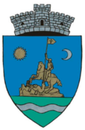
- Picture with the statue of St. George slaying the dragon, the symbol of the community
Individual evidence
- ↑ 2011 census in Romania ( MS Excel ; 1.3 MB)
- ↑ Arcanum Kézikönyvtár: Historical-administrative book of place names of Transylvania, Banat and Partium. Retrieved October 20, 2018 (Hungarian).
- ↑ a b c d Heinz Heltmann, Gustav Servatius (Ed.): Travel Guide Siebenbürgen . Kraft, Würzburg 1993, ISBN 3-8083-2019-2 , p. 517 .
- ↑ Institute Of Archeology - Sângeorgiu de Mureș accessed on October 20, 2018 (Romanian)
- ↑ Censuses 1850–2002, last updated November 2, 2008 (PDF; 1 MB; Hungarian)
- ↑ Nagy-Bodó Tibor: A Petki-Máriaffy-Kastell. kozpont.ro, July 21, 2016, accessed October 20, 2018 (Hungarian).
- ↑ a b List of historical monuments of the Romanian Ministry of Culture, updated 2015 (PDF; 12.7 MB; Romanian)
- ↑ Rehabilitation - Work on Máriaffy Castle has started and will be converted into a cultural and tourist center , at msnews.ro, on April 20, 2018, accessed on October 20, 2018 (Romanian)
- ↑ Aerial view of the health resort in Sângeorgiu de Mureș
- ↑ Nicolae Balint: Brief history of a squandered wealth. zi-de-zi.ro, February 3, 2008, accessed October 20, 2018 (Romanian).


