
Crăieşti
|
Crăiești prince village Mezőkirályfalva |
|||||
|
|||||
| Basic data | |||||
|---|---|---|---|---|---|
| State : |
|
||||
| Historical region : | Transylvania | ||||
| Circle : | Mureș | ||||
| Coordinates : | 46 ° 45 ' N , 24 ° 25' E | ||||
| Time zone : | EET ( UTC +2) | ||||
| Height : | 348 m | ||||
| Area : | 23.49 km² | ||||
| Residents : | 924 (October 20, 2011) | ||||
| Population density : | 39 inhabitants per km² | ||||
| Postal code : | 547180 | ||||
| Telephone code : | (+40) 02 65 | ||||
| License plate : | MS | ||||
| Structure and administration (as of 2016) | |||||
| Community type : | local community | ||||
| Structure : | Crăiești, Lefaia , Milășel , Nima Milășelului | ||||
| Mayor : | Vasile Vereș ( PNL ) | ||||
| Postal address : | Str. Principală, no. 122 / a loc. Crăieşti, jud. Mureș, RO-547180 |
||||
| Website : | |||||


Crăiești [ ˈkrəieʃtʲ ] (outdated Craifalău de Câmpie ; German Fürstendorf , Hungarian Mezőkirályfalva ) is a municipality in the Mureș County , in the Transylvania region in Romania .
The place is also known under the Hungarian name Királyfalva .
Geographical location

The municipality of Crăieşti is located in the Transylvanian Basin in the west of the Mureş district. On the upper reaches of the Lechința a right tributary of the Mureș (Mieresch) and the Drum național 16 , the place Crăiești is located about 35 kilometers north of the district capital Târgu Mureș (Neumarkt am Mieresch) .
The Mocănița Transilvaniei narrow-gauge railway runs between Teaca in the Bistrița-Năsăud district and the neighboring municipality of Râciu to the south . After a long period of shutdown, the train will run again for the first time in spring 2017 on the approximately 35-kilometer route.
history
The place Crăieşti was first mentioned in 1549. In the Kingdom of Hungary the place belonged to the chair district Mezőörményes in the team shank Cluj on; the villages that are incorporated today belonged to the Maros Felső (Ober-Maros) district in Maros-Torda County , then to the historical Mureș District and, from 1950, today's Mureș District.
population
The population of the Crăiești municipality developed as follows:
| census | Ethnic composition | ||||
|---|---|---|---|---|---|
| year | population | Romanians | Hungary | German | other |
| 1850 | 944 | 801 | 71 | 2 | 70 |
| 1930 | 1,400 | 1,262 | 97 | 1 | 40 |
| 1966 | 1,988 | 1.927 | 59 | - | 2 |
| 2002 | 1,026 | 1,019 | 7th | - | - |
| 2011 | 924 | 888 | 5 | - | 31 |
Since 1850, the highest number of inhabitants and that of Romanians in 1966 have been registered in the area of today's municipality. The highest number of Magyars (152) was determined in 1941, the Roma (70) in 1850 and that of the Romanian Germans (26) in 1900.
Attractions
- The Orthodox and Reformed Churches built in the community center at the end of the 18th century.
- In the incorporated village of Milășel (Hungarian Kisnyulas ) the wooden church.

Town hall in Crăieşti
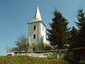
Reformed church in Crăieşti

Wooden church in Milășel


Web links
Individual evidence
- ↑ 2011 census in Romania ( MS Excel ; 1.3 MB)
- ↑ Arcanum Kézikönyvtár: Historical-administrative book of place names of Transylvania, Banat and Partium. Retrieved December 6, 2018 (Hungarian).
- ^ Marius Frățilă: Bistrița-Năsăud: Mocănița Transilvaniei își reia cursele turistice la sfârșitul lunii mai. AGERPRES, May 17, 2017, accessed December 6, 2018 (Romanian).
- ↑ Heinz Heltmann, Gustav Servatius (Ed.): Travel Guide Siebenbürgen . Kraft, Würzburg 1993, ISBN 3-8083-2019-2 , p. 517 .
- ↑ Censuses 1850–2002, last updated November 2, 2008 (PDF; 1 MB; Hungarian)
- ↑ Information on the Orthodox Church in Crăiești at biserici.org, accessed on December 9, 2018 (Romanian)
- ↑ Information on the Reformed Church in Crăiești at biserici.org, accessed on December 9, 2018 (Romanian)
- ↑ Information on the wooden church in Milășel at biserici.org, accessed on December 9, 2018 (Romanian)
Acățari | Adămuș | Albeşti | Aluniș | Apold | Ațintiș | Băgaciu | Bahnea | Băla | Bălăușeri | Band | Batoș | Beica de Jos | Bereni | Bichiș | Bogata | Brâncoveneşti | Breaza | Ceuașu de Câmpie | Chețani | Chiheru de Jos | Coroisânmărtin | Corunca | Cozma | Crăciuneşti | Crăiești | Cristești | Cucerdea | Cuci | Daneș | Deda | Hermit | Ernei | Fântânele | Fărăgău | Gălești | Găneşti | Gheorghe Doja | Ghindari | Glodeni | Gorneşti | Grebenișu de Câmpie | Gurghiu | Hodac | Hodoșa | Ibăneşti | Iclănzel | Ideciu de Jos | Livezeni | Lunca | Lunca Bradului | Măgherani | Mica | Miheșu de Câmpie | Nadeș | Neaua | Ogra | Pănet | Papiu Ilarian | Păsăreni | Petelea | Pogăceaua | Râciu | Răstolița | Rușii-Munți | Sâncraiu de Mureș | Sângeorgiu de Mureș | Singer | Sânpaul | Sânpetru de Câmpie | Sântana de Mureș | Saschiz | Sărățeni | Șăulia | Șincai | Solovăstru | Stânceni | Suplac | Suseni | Tăureni | Valea Largă | Vânători | Vărgata | Vătava | Vețca | Viișoara | Voivodeni | Zagăr | Zau de Câmpie