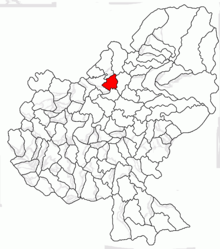
Breaza (Mureș)
|
Breaza Bretzdorf Beresztelke |
||||
|
||||
| Basic data | ||||
|---|---|---|---|---|
| State : |
|
|||
| Historical region : | Transylvania | |||
| Circle : | Mureș | |||
| Coordinates : | 46 ° 46 ' N , 24 ° 38' E | |||
| Time zone : | EET ( UTC +2) | |||
| Height : | 375 m | |||
| Area : | 41.39 km² | |||
| Residents : | 2,473 (October 20, 2011) | |||
| Population density : | 60 inhabitants per km² | |||
| Postal code : | 547135 | |||
| Telephone code : | (+40) 02 65 | |||
| License plate : | MS | |||
| Structure and administration (as of 2016) | ||||
| Community type : | local community | |||
| Structure : | Breaza, Filpişu Mare , Filpişu Mic | |||
| Mayor : | Gheorghe Chira ( PNL ) | |||
| Postal address : | Str. Principală, no. 129 loc. Breaza, jud. Mureș, RO-547135 |
|||
| Website : | ||||
Breaza (outdated Brețcu ; German Bretzdorf , Hungarian Beresztelke ) is a municipality in the district of Mureș , in the Transylvania region in Romania .
Geographical location
The municipality of Breaza is located west of the Reener Ländchen (Ținutul Reghinului) in the northern part of the Transylvanian Basin . On the Luț , a right tributary of the Mureș (Mieresch) and the national road DN16 , the place Breaza is located six kilometers southwest of the city of Reghin (Saxon rain) and about 30 kilometers north of the district capital Târgu Mureș (Neumarkt am Mieresch) . The incorporated villages are located five and four kilometers from the community center.
history
The place Breaza was first mentioned in 1319. According to Márton Roska and Kurt Horedt, settlement on the area around Breaza is dated to the Bronze Age. Numerous archaeological finds were found in the area of the road to Reghin (DN16) and the Luț (Hungarian Lucpatak ) stream behind the mill, as well as in the direction of Bistrița (Bistriz) ( DN15A ) and the village of Sântu in the neighboring community of Lunca .
In the Kingdom of Hungary , today's municipality belonged to the Régen alsó (Lower Rain) district in Maros-Torda County , then to the historical Mureș District and, from 1950, today's Mureș District.
population
The population of the municipality of Breaza developed as follows:
| census | Ethnic composition | ||||
|---|---|---|---|---|---|
| year | population | Romanians | Hungary | German | other |
| 1850 | 1.913 | 737 | 981 | - | 195 |
| 1910 | 2,648 | 942 | 1,610 | 20th | 76 |
| 1956 | 3,120 | 1,364 | 1,694 | 1 | 58 |
| 2002 | 2,531 | 1.105 | 1,138 | 3 | 285 |
| 2011 | 2,473 | 1.110 | 1,025 | 2 | 336 |
Since 1850, the highest number of inhabitants was registered in the area of today's municipality in 1956. The highest number of Romanians (1,381) was found in 1977, the Magyars (1,905) in 1941, the Roma (284) in 2002 and that of the Romanian Germans (22) in 1890.
Attractions
- In the community center the reformed church , built at the beginning of the 15th century and the bell tower in 1895, are under monument protection.
- In the incorporated village of Filpișu Mare (Großphlepsdorf) , the reformed church built in the 15th century, renewed in the 18th and the wooden bell tower built at the same time, are under monument protection.
- In the incorporated village of Filpișu Mic (Kleinphlepsdorf) , the Reformed Church was built around 1836.
Web links
Individual evidence
- ↑ 2011 census in Romania ( MS Excel ; 1.3 MB)
- ↑ Heinz Heltmann, Gustav Servatius (Ed.): Travel Guide Siebenbürgen . Kraft, Würzburg 1993, ISBN 3-8083-2019-2 , p. 517 .
- ^ Institute Of Archeology - Breaza , accessed July 21, 2018 (Romanian).
- ↑ Censuses 1850–2002, last updated November 2, 2008 (PDF; 1 MB; Hungarian)
- ↑ Information on the Reformed Church in Breaza at biserici.org, accessed on July 21, 2018 (Romanian)
- ↑ a b List of historical monuments of the Romanian Ministry of Culture, updated 2015 (PDF; 12.7 MB; Romanian)
- ↑ Information on the Reformed Church in Filpișu Mare at biserici.org, accessed on July 21, 2018 (Romanian)
- ↑ Information on the Reformed Church in Filpișu Mic at biserici.org, accessed on July 21, 2018 (Romanian)


