
Cuci
|
Cuci Kokt Kutyfalva |
|||||
|
|||||
| Basic data | |||||
|---|---|---|---|---|---|
| State : |
|
||||
| Historical region : | Transylvania | ||||
| Circle : | Mureș | ||||
| Coordinates : | 46 ° 28 ' N , 24 ° 9' E | ||||
| Time zone : | EET ( UTC +2) | ||||
| Height : | 279 m | ||||
| Area : | 42.10 km² | ||||
| Residents : | 1,822 (October 20, 2011) | ||||
| Population density : | 43 inhabitants per km² | ||||
| Postal code : | 547195 | ||||
| Telephone code : | (+40) 02 65 | ||||
| License plate : | MS | ||||
| Structure and administration (as of 2016) | |||||
| Community type : | local community | ||||
| Structure : | Cuci, Dătășeni , După Deal , Orosia , Petrilaca | ||||
| Mayor : | Ilie Șuta ( PSD ) | ||||
| Postal address : | Str. Principală, no. 280 loc. Cuci, jud. Mureș, RO-547195 |
||||
| Website : | |||||
| Others | |||||
| City Festival : | the parish festival in May | ||||


Cuci [ ˈkut͡ʃʲ ] (outdated Cuciu ; German Kokt , Hungarian Kutyfalva ) is a municipality in the Mureș County , in the Transylvania region in Romania .
The place Cuci is also known under the German name Quellendorf .
Geographical location

The municipality of Cuci is located in the Transylvanian Basin in the west of the Mureș district. At the mouth of the Pârâul Luncilor creek in the Mureș (Mieresch) , the national road 15 and the Alba Iulia – Târgu Mureș railway line , the place Cuci is seven kilometers east of the small town of Luduș (Ludasch) and about 40 kilometers west of the district capital of Târgu Mureș (Neumarkt am Mieresch) away.
The planned Romanian A3 , also known as Autostrada Transilvania , is to run around two kilometers south of Cuci .
history
The place Cuci was first mentioned in a document in 1331 or 1410, according to various sources. To a settlement of the municipality area interpret archaeological finds in the area, known locally Berc (Hungarian Berec ), between the community center and the unincorporated village Dătăşeni (Dalmesch) in the Latènezeit . Because of the existing Roman road , settlement in Roman times is suspected.
Other settlements in the Latène period are also reported in the incorporated village of Dătăşeni and near Orosia (Russian village) in the Neolithic period .
In the Kingdom of Hungary the places belonged to the church today, the north of the Mures the chair district are Marosludas in the county Torda-Aranyos , the southern chair District Marosújvár in County Unterweißburg , then all the historical district Turda and from 1950 to today's county Mures on.
The village of După Deal is one of the currently 130 uninhabited villages in Romania, six of them in the Mureș County (as of 2018) and is no longer noted in the municipality's web presentation.
population
The population of the municipality of Cuci developed as follows:
| census | Ethnic composition | ||||
|---|---|---|---|---|---|
| year | population | Romanians | Hungary | German | other |
| 1850 | 2,510 | 1.915 | 389 | 4th | 202 |
| 1920 | 2,746 | 1,973 | 731 | 2 | 40 |
| 1966 | 3,467 | 2,872 | 559 | 3 | 33 |
| 2002 | 2,200 | 1,733 | 313 | 2 | 152 |
| 2011 | 1,822 | 1,351 | 242 | 2 | 227 |
Since 1850, the highest number of inhabitants and that of Romanians in 1966 have been determined in the area of today's municipality. The highest number of Magyars was registered in 1920, Roma (185) in 2011 and Romanian Germans (26) in 1910.
Attractions
- In the community center the reformed church and the bell tower built in the 15th century, renewed in 1835 and the wooden church Sf. Arhangheli, built in the 17th century and renovated in the 19th, are a listed building.
- In the community center the country house, the associated buildings and park of the Hungarian aristocratic family Degenfeld , built in the 19th century by Miksa Kristóf Degenfeld, expanded in the 20th century by Lajos Degenfeld and the family crypt , are listed. In communist Romania , the village blacksmith had dismantled the iron-cast coat of arms of the building and only gave it back to the legal successors of the property. Since the collectivization and until 1970 the offices of the agricultural enterprise, then the town hall, the library and the police of the community were housed here. Since the transfer of the property to the legal heirs, it was opened for inspection for the first time on June 29, 2019.
- In the incorporated village of Petrilaca (Petersheim) the reformed church built from 1782 to 1786 and the bell tower added in 1861 are under monument protection.
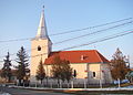
Reformed Church in Cuci

Wooden church in Cuci

Main house of the Degenfeld property
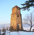
Water tower of the Degenfeld property
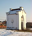
Crypt of the Degenfeld family
.JPG)
.JPG)
.JPG)
.JPG)
.JPG)
Web links
Individual evidence
- ↑ 2011 census in Romania ( MS Excel ; 1.3 MB)
- ↑ Arcanum Kézikönyvtár: Historical-administrative book of place names of Transylvania, Banat and Partium. Retrieved July 13, 2019 (Hungarian).
- ↑ Heinz Heltmann, Gustav Servatius (Ed.): Travel Guide Siebenbürgen . Kraft, Würzburg 1993, ISBN 3-8083-2019-2 .
- ↑ Information on the website of the municipality of Cuci accessed on July 13, 2019 (Romanian).
- ↑ Institute Of Archeology - Cuci , accessed on July 14, 2019 (Romanian).
- ↑ Institute Of Archeology - Dătăşeni , accessed on July 14, 2019 (Romanian).
- ^ Institute Of Archeology - Orosia , accessed July 14, 2019 (Romanian).
- ↑ INEDIT. Șase localități mureșene sunt nelocuite, există doar pe hârtie! ardealnews.ro, December 27, 2018, accessed July 13, 2019 (Romanian).
- ↑ Censuses 1850–2002, last updated November 2, 2008 (PDF; 1 MB; Hungarian).
- ↑ a b c List of historical monuments of the Romanian Ministry of Culture, updated 2015 (PDF; 12.7 MB; Romanian).
- ↑ Information on the Degenfeld property from castelintransilvania.ro accessed on July 14, 2019 (Hungarian, Romanian, English).
- ↑ Erika Marginean: Ziua porților deschise la Castelul Degenfeld din Cuci. punctul.ro, June 11, 2019, accessed July 14, 2019 (Romanian).
- ↑ Information on the Reformed Church in Petrilaca from biserici.org accessed on June 14, 2019 (Romanian).
Acățari | Adămuș | Albeşti | Aluniș | Apold | Ațintiș | Băgaciu | Bahnea | Băla | Bălăușeri | Band | Batoș | Beica de Jos | Bereni | Bichiș | Bogata | Brâncoveneşti | Breaza | Ceuașu de Câmpie | Chețani | Chiheru de Jos | Coroisânmărtin | Corunca | Cozma | Crăciuneşti | Crăiești | Cristești | Cucerdea | Cuci | Daneș | Deda | Hermit | Ernei | Fântânele | Fărăgău | Gălești | Găneşti | Gheorghe Doja | Ghindari | Glodeni | Gorneşti | Grebenișu de Câmpie | Gurghiu | Hodac | Hodoșa | Ibăneşti | Iclănzel | Ideciu de Jos | Livezeni | Lunca | Lunca Bradului | Măgherani | Mica | Miheșu de Câmpie | Nadeș | Neaua | Ogra | Pănet | Papiu Ilarian | Păsăreni | Petelea | Pogăceaua | Râciu | Răstolița | Rușii-Munți | Sâncraiu de Mureș | Sângeorgiu de Mureș | Singer | Sânpaul | Sânpetru de Câmpie | Sântana de Mureș | Saschiz | Sărățeni | Șăulia | Șincai | Solovăstru | Stânceni | Suplac | Suseni | Tăureni | Valea Largă | Vânători | Vărgata | Vătava | Vețca | Viișoara | Voivodeni | Zagăr | Zau de Câmpie