
Brâncoveneşti
|
Brâncoveneşti Wetsch Marosvécs |
|||||
|
|||||
| Basic data | |||||
|---|---|---|---|---|---|
| State : |
|
||||
| Historical region : | Transylvania | ||||
| Circle : | Mureș | ||||
| Coordinates : | 46 ° 51 ' N , 24 ° 46' E | ||||
| Time zone : | EET ( UTC +2) | ||||
| Height : | 402 m | ||||
| Area : | 87.62 km² | ||||
| Residents : | 3,972 (October 20, 2011) | ||||
| Population density : | 45 inhabitants per km² | ||||
| Postal code : | 547130 | ||||
| Telephone code : | (+40) 02 65 | ||||
| License plate : | MS | ||||
| Structure and administration (as of 2016) | |||||
| Community type : | local community | ||||
| Structure : | Brâncoveneşti, Idicel , Idicel-Pădure , Săcalu de Pădure , Vălenii de Mureș | ||||
| Mayor : | Ferencz Őrdőg ( UDMR ) | ||||
| Postal address : | Str. Principală, no. 303 loc. Brâncoveneşti, jud. Mureș, RO-547130 |
||||
| Website : | |||||
| Others | |||||
| City Festival : | 1st Sunday in June, Culesul cireșelor (cherry picking ) | ||||


Brâncoveneşti [ ˈbrɨnkoveneʃtʲ ] (obsolete Ieciu or Delavrancea ; German Wetsch , Hungarian Marosvécs or Vécs ) is a municipality in the Mureş district , in the Transylvania region in Romania .
Geographical location

The municipality of Brâncoveneşti is located in the Reener Ländchen (Ținutul Reghinului) in the northern part of the Transylvanian Basin . On the right bank of the Mureș (Mieresch) , at Drum național 15 and on the Târgu Mureș – Deda – Gheorgheni railway line , the place is ten kilometers northeast of the city of Reghin (Saxon Rain) and about 40 kilometers northeast of the district capital of Târgu Mureș (Neumarkt am Mieresch) . The incorporated villages are between five and ten kilometers from the community center.
history
The place Brâncoveneşti was first mentioned in 1228.
Archaeological finds in the garden of the Brâncoveneşti Castle indicate that the place was settled in Roman times . In the 1970s, excavations led by the archaeologist Dumitru Protase found traces of the Brâncoveneşti castle . Furthermore, over 40 urns were found in a forest north of the community center, these have not yet been assigned to an era. Also in the incorporated village of Vălenii de Mureș (alleys) , a watchtower is noted on the area, called by the locals (Elövár) , which also dates from Roman times.
In the Kingdom of Hungary , today's municipality belonged to the Régen Felső (Ober-Regen) district in Maros-Torda County , then to the historical Mureș District and, from 1950, today's Mureș District.
population
The population of the Brâncoveneşti municipality developed as follows:
| census | Ethnic composition | ||||
|---|---|---|---|---|---|
| year | population | Romanians | Hungary | German | other |
| 1850 | 3,619 | 1,950 | 1,370 | - | 299 |
| 1920 | 5,032 | 2,978 | 2.005 | 4th | 45 |
| 1941 | 5,529 | 2,830 | 2,421 | 8th | 270 |
| 2002 | 4,518 | 2,080 | 2,256 | - | 182 |
| 2011 | 3,972 | 1,593 | 1,852 | - | 527 |
Since 1850 the highest number of inhabitants (5,568) was registered in 1977 in the area of today's municipality. The highest number of Romanians was determined in 1920, that of the Magyars (2,837) in 1977, the Roma (298) in 2011 and that of the Romanian Germans (36) in 1900. In addition, 15 Ukrainians were registered in 1941 .
Attractions
- In Brâncoveneşti, the Kemény Castle, built in the 16th century and renovated in the 19th, was nationalized in 1948 and, in a neglected state, served as a home for disabled children. The last owner of the castle was the writer Janos Kemény (1903–1971). The castle was officially taken over by his descendants on November 8, 2014.
- In the community center, the reformed church built in 1727 and a Roman camp on the grounds of the Kemény castle, are listed as historical monuments. Furthermore, next to the Roman camp to the so-called "Pădurea Trandafirilor" ( Rosenwald , Hungarian Rószás a) Roman road and a pottery noted.
- In the incorporated village of Vălenii de Mureș the reformed church was built in the 16th century. Here are grave monuments from 1764 of the Hungarian noble family Rhédei . The church is a listed building.
- In the incorporated village of Săcalu de Pădure (Bartdorf) , the wooden church Înălțarea Domnului built in the old cemetery in 1809 is a listed building.
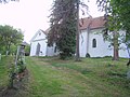
Reformed Church in Brâncoveneşti

Wooden church in Săcalu de Pădure

Reformed Church in Vălenii de Mureș

The Kemény Castle
.jpg)
.jpg)
.jpg)

Personalities
- Csaba Németh (* 1951), born in Brâncoveneşti, publicist and until 2008 Senator of the UDMR in the Romanian Senate .
Web links
- Brâncoveneşti at ghidulprimariilor.ro
- Andreea Milea: Parcul castelului Kendi-Kemény din Brâncoveneşti, județul Mureş. ( PDF ; 1.2 MB) Accessed August 31, 2018 (Romanian, English).
Individual evidence
- ↑ 2011 census in Romania ( MS Excel ; 1.3 MB)
- ↑ Arcanum Kézikönyvtár: Historical-administrative book of place names of Transylvania, Banat and Partium. Retrieved August 27, 2018 (Hungarian).
- ↑ a b c Heinz Heltmann, Gustav Servatius (ed.): Travel Guide Siebenbürgen . Kraft, Würzburg 1993, ISBN 3-8083-2019-2 , p. 517 .
- ↑ Nicolae Gudea : The Dacian Limes. Materials on its story. In: Yearbook of the Römisch Germanisches Zentralmuseum Mainz. 44, 2, 1997, p. 67f., ( Digitized version ).
- ^ A b Institute Of Archeology - Brâncovenești , accessed on August 31, 2018 (Romanian).
- ↑ Institute Of Archeology - Vălenii de Mureș accessed on August 31, 2018 (Romanian)
- ↑ Censuses 1850–2002, last updated November 2, 2008 (PDF; 1 MB; Hungarian)
- ↑ View of the castle
- ↑ Contribution to the official handover of the castle in Brâncoveneşti on November 11, 2014 on YouTube , accessed on August 31, 2018 (Romanian)
- ↑ Information on the Reformed Church in Brâncoveneşti at biserici.org, accessed on August 31, 2018 (Romanian)
- ↑ a b c List of historical monuments of the Romanian Ministry of Culture, updated 2015 (PDF; 12.7 MB; Romanian)
- ↑ Information on the Reformed Church in Vălenii de Mureș at biserici.org, accessed on August 31, 2018 (Romanian)
- ^ Website of the Romanian Chamber of Deputies: NÉMETH Csaba. Camera Deputaților, accessed August 31, 2018 (Romanian).
Acățari | Adămuș | Albeşti | Aluniș | Apold | Ațintiș | Băgaciu | Bahnea | Băla | Bălăușeri | Band | Batoș | Beica de Jos | Bereni | Bichiș | Bogata | Brâncoveneşti | Breaza | Ceuașu de Câmpie | Chețani | Chiheru de Jos | Coroisânmărtin | Corunca | Cozma | Crăciuneşti | Crăiești | Cristești | Cucerdea | Cuci | Daneș | Deda | Hermit | Ernei | Fântânele | Fărăgău | Gălești | Găneşti | Gheorghe Doja | Ghindari | Glodeni | Gorneşti | Grebenișu de Câmpie | Gurghiu | Hodac | Hodoșa | Ibăneşti | Iclănzel | Ideciu de Jos | Livezeni | Lunca | Lunca Bradului | Măgherani | Mica | Miheșu de Câmpie | Nadeș | Neaua | Ogra | Pănet | Papiu Ilarian | Păsăreni | Petelea | Pogăceaua | Râciu | Răstolița | Rușii-Munți | Sâncraiu de Mureș | Sângeorgiu de Mureș | Singer | Sânpaul | Sânpetru de Câmpie | Sântana de Mureș | Saschiz | Sărățeni | Șăulia | Șincai | Solovăstru | Stânceni | Suplac | Suseni | Tăureni | Valea Largă | Vânători | Vărgata | Vătava | Vețca | Viișoara | Voivodeni | Zagăr | Zau de Câmpie