
Gorneşti
|
Gorneşti Kertzing Gernyeszeg |
|||||
|
|||||
| Basic data | |||||
|---|---|---|---|---|---|
| State : |
|
||||
| Historical region : | Transylvania | ||||
| Circle : | Mureș | ||||
| Coordinates : | 46 ° 40 ' N , 24 ° 39' E | ||||
| Time zone : | EET ( UTC +2) | ||||
| Height : | 343 m | ||||
| Area : | 85.17 km² | ||||
| Residents : | 5,577 (October 20, 2011) | ||||
| Population density : | 65 inhabitants per km² | ||||
| Postal code : | 547280 | ||||
| Telephone code : | (+40) 02 65 | ||||
| License plate : | MS | ||||
| Structure and administration (as of 2016) | |||||
| Community type : | local community | ||||
| Structure : | Gornești, Iara de Mureș , Ilioara , Mura Mare , Mura Mică , Pădureni , Periș , Petrilaca de Mureș , Teleac | ||||
| Mayor : | Gyula Kolcsár ( UDMR ) | ||||
| Postal address : | Str. Pricipală nr. 429 loc. Gorneşti, jud. Mureș, RO-547280 |
||||
| Website : | |||||


Gorneşti [ gorˈneʃtʲ ] (outdated Gernesig ; German Kertzing , Hungarian Gernyeszeg ) is a municipality in the Mureş County , in the Transylvania region in Romania .
Geographical location

The municipality of Gorneşti is located in the Mureş Valley in the Transylvanian Basin north of the Kokel Highlands (Podişul Târnavelor) . In the center of the Mureş am Mureş (Mieresch) district , the DN 15 national road and the Târgu Mureş – Gheorgheni railway line, Gorneşti is located 17 kilometers north of the district capital of Târgu Mureş (Neumarkt am Mieresch) .
history
The place Gorneşti, a place mostly inhabited by Magyars, was first mentioned in 1319. Settlement of the place is assigned to the Neolithic Age according to archaeological excavations . Numerous archaeological objects are dated from the Latène period to the Neolithic period.
In the incorporated village of Mura Mică (Klein-Sedresch) 187 coins, of which 132 were Thasitic coins, were found. These have been in a Budapest museum since 1903 . Also in the incorporated village of Pădureni (Scholten) finds from the Neolithic to the Iron Age were assigned. East of the incorporated village of Petrilaca de Mureș (Petershausen; Petersdorf) , on the area called Ciortos by the locals , in the directory of historical monuments of the Ministry of Culture and National Heritage (Ministerul Culturii și Patrimoniului Național) there is a settlement in the Bronze Age of the Wietenberg culture assigned.
At the time of the Kingdom of Hungary , today's municipality belonged to the chair district Régen alsó ("Unter-Regen") in the Maros-Torda County, then to the historical Mureș County and from 1950 to the present Mureș County.
population
The population of today's Gorneşti municipality developed as follows:
| census | Ethnic composition | ||||
|---|---|---|---|---|---|
| year | population | Romanians | Hungary | German | other |
| 1850 | 4,786 | 1,297 | 3.151 | 5 | 333 |
| 1930 | 6,719 | 1,909 | 4,413 | 8th | 389 |
| 1956 | 7,739 | 1,801 | 5,685 | 4th | 249 |
| 2002 | 5,885 | 1,122 | 4,437 | 2 | 324 |
| 2011 | 5,577 | 1.005 | 3,912 | 2 | 658 |
Since 1850, the highest number of inhabitants in the area of today's municipality was determined in 1956. The highest number of Magyars (5,695) was registered in 1941, Romanians in 1930, Roma (519) in 2011 and Romanian Germans (21) in 1910.
Attractions
- In the community center, Teleki Castle, first mentioned in 1477 and rebuilt in Baroque style in 1770, and its park laid out in the 19th century, are listed as historical monuments. The castle has 52 rooms and 365 windows. In the park there are classical grotesque sandstone figures.
- In the community center, the reformed church built in the 15th century and rebuilt several times, and the crypt in the church in which Mihály Teleki and his wife Judit Weér are buried, are listed as historical monuments.
- The Orthodox Church of Sf. Arhangheli Mihail și Gavril in Gornești, was built in 1912 on the site of a crumbling wooden church .
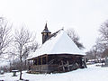
- In the incorporated village of Mura Mare (Gross-Sedresch; Himbeerdorf) two wooden churches, both built in the 17th century, are listed. The Sf. Arhangheli Mihail și Gavril and Sf. Nicolae Church is in good condition, while the Sf. Arhangheli Mihail și Gavril collapsed in the winter of 2008/09.
- In the incorporated village of Periș (Birnbaum), the reformed church built in the 14th century and rebuilt several times is a listed building. The church was originally a Catholic then an Evangelical and now a Reformed Church. The wooden bell tower of the church, which is also a listed building, was brought here from Petelea (Birk) in 1768 .

Teleki Castle

Church in Gorneşti

Wooden church in Mura Mare
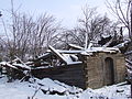
Crumbled wooden church in Mura Mare
Wooden church in Mura Mică
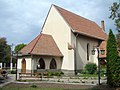
Church in Periș

Bell tower in Periș
.JPG)
.jpg)


.jpg)
Personalities
- Michael Teleki (1634–1690), was chancellor and advisor to the Transylvanian prince and was buried in the crypt of the church in the parish center.
- Sámuel Teleki (1739-1822), was Chancellor of Transylvania, founder of the Teleki Library in Târgu Mureş.
- István Bethlen (1874–1946?) Was a Hungarian politician
- Alexandru Todea (1912-2002), was Archbishop of Făgăraş and Alba Iulia for the Romanian Greek Catholic Church and cardinal of the Roman Church .
Web links
Individual evidence
- ↑ 2011 census in Romania ( MS Excel ; 1.3 MB)
- ↑ a b c Heinz Heltmann, Gustav Servatius (ed.): Travel Guide Siebenbürgen . Kraft, Würzburg 1993, ISBN 3-8083-2019-2 , p. 517 .
- ↑ Institute Of Archeology - Gornesti , accessed on September 24, 2019 (Romanian).
- ^ Institute Of Archeology - Mura Mică , accessed September 24, 2019 (Romanian).
- ^ Institute Of Archeology - Pădureni , accessed September 24, 2019 (Romanian).
- ↑ a b c d e List of historical monuments of the Romanian Ministry of Culture , updated 2015 (PDF; 12.7 MB; Romanian).
- ↑ Censuses 1850–2002, last updated November 2, 2008 (PDF; 1 MB; Hungarian).
- ↑ Information on the Reformed Church in Gorneşti at biserici.org, accessed on September 24, 2018 (Romanian).
- ↑ Teleki Mihály, Burials. (PDF; 12.9 MB) Retrieved September 24, 2019 (Hungarian).
- ↑ Information on the Orthodox Church in Gorneşti at biserici.org, accessed on September 24, 2018 (Romanian).
- ↑ Information on the wooden church in Mura Mare at biserici.org, accessed on September 24, 2018 (Romanian).
- ↑ Information on the collapsed wooden church in Mura Mare at biserici.org, accessed on September 24, 2018 (Romanian).
- ↑ Information on the church in Periș at biserici.org, accessed on September 24, 2018 (Romanian).
- ↑ Information on Sámuel Teleki, retrieved from mek.oszk.hu on September 9, 2019 (Hungarian).
Acățari | Adămuș | Albeşti | Aluniș | Apold | Ațintiș | Băgaciu | Bahnea | Băla | Bălăușeri | Band | Batoș | Beica de Jos | Bereni | Bichiș | Bogata | Brâncoveneşti | Breaza | Ceuașu de Câmpie | Chețani | Chiheru de Jos | Coroisânmărtin | Corunca | Cozma | Crăciuneşti | Crăiești | Cristești | Cucerdea | Cuci | Daneș | Deda | Hermit | Ernei | Fântânele | Fărăgău | Gălești | Găneşti | Gheorghe Doja | Ghindari | Glodeni | Gorneşti | Grebenișu de Câmpie | Gurghiu | Hodac | Hodoșa | Ibăneşti | Iclănzel | Ideciu de Jos | Livezeni | Lunca | Lunca Bradului | Măgherani | Mica | Miheșu de Câmpie | Nadeș | Neaua | Ogra | Pănet | Papiu Ilarian | Păsăreni | Petelea | Pogăceaua | Râciu | Răstolița | Rușii-Munți | Sâncraiu de Mureș | Sângeorgiu de Mureș | Singer | Sânpaul | Sânpetru de Câmpie | Sântana de Mureș | Saschiz | Sărățeni | Șăulia | Șincai | Solovăstru | Stânceni | Suplac | Suseni | Tăureni | Valea Largă | Vânători | Vărgata | Vătava | Vețca | Viișoara | Voivodeni | Zagăr | Zau de Câmpie