
Gălești (Mureș)
|
Gălești Gallendorf Nyárádgálfalva |
|||||
|
|||||
| Basic data | |||||
|---|---|---|---|---|---|
| State : |
|
||||
| Historical region : | Transylvania | ||||
| Circle : | Mureș | ||||
| Coordinates : | 46 ° 31 ' N , 24 ° 45' E | ||||
| Time zone : | EET ( UTC +2) | ||||
| Height : | 357 m | ||||
| Area : | 57.79 km² | ||||
| Residents : | 3,067 (October 20, 2011) | ||||
| Population density : | 53 inhabitants per km² | ||||
| Postal code : | 547245 | ||||
| Telephone code : | (+40) 02 65 | ||||
| License plate : | MS | ||||
| Structure and administration (as of 2016) | |||||
| Community type : | local community | ||||
| Structure : | Gălești, Adrianu Mare , Adrianu Mic , Bedeni , Maiad , Sânvăsii , Troița | ||||
| Mayor : | Károly Karácsony ( UDMR ) | ||||
| Postal address : | Str. Principală, no. 64 loc. Găleşti, jud. Mureș, RO-547245 |
||||
| Website : | |||||
| Others | |||||
| City Festival : | April 25th and August 22nd, annual fair | ||||


Găleşti [ ˈgəleʃtʲ ] (outdated Galfalău ; German Gallendorf , Hungarian Nyárádgálfalva or Gálfalva ) is a municipality in the Mureş district , in the Transylvania region in Romania .
Geographical location

The municipality of Gălești is located north of the Kokel Valley (Podișul Târnavelor) in the southern part of the Mureș County. On the Niraj , a left tributary of the Mureș (Mieresch) and the district road (Drum județean) DJ 151D (6 km east of the DN13 ), the place Gălești is 18 kilometers southeast of the district capital Târgu Mureș (Neumarkt am Mieresch) .
Until about 2010 a narrow-gauge railway operated on the area of the municipality of the original narrow-gauge line from Cristeşti to the small spa town of Sovata (Szováta) .
history
The place Găleşti, founded by Szekler , was first mentioned in 1501. The remains of a castle on the area known by the locals as Sigervára of the incorporated village of Sânvăsii (Hungarian Nyárádszentlászló ) indicate that the village was settled in the Middle Ages . Numerous archaeological finds from the Neolithic to Roman times were found on the area of the community center.
In the Kingdom of Hungary , today's municipality belonged to the Maros Felső (Ober-Maros) district in Maros-Torda County , then to the historical Mureș District and, from 1950, today's Mureș District.
population
The population of the municipality of Gălești developed as follows:
| census | Ethnic composition | ||||
|---|---|---|---|---|---|
| year | population | Romanians | Hungary | German | other |
| 1850 | 3,317 | 398 | 2,715 | - | 204 |
| 1900 | 3,947 | 12 | 3,909 | 16 | 10 |
| 1956 | 4,566 | 68 | 4,411 | 1 | 86 |
| 2002 | 2,940 | 44 | 2,752 | - | 144 |
| 2011 | 3,067 | 68 | 2,611 | - | 388 (Roma 45) |
Since 1850, the highest number of inhabitants and that of the Magyars were registered in the area of today's municipality in 1956. The highest population of Romanians (1,316) was determined in 1920, that of Roma (200) in 1850 and that of Romanian Germans in 1900.
Attractions
- In the community center the house of the Tonay family (Str. Principală, no. 54), built in the 17th century, is a listed building.
- In the seven villages of Gălești municipality, 18 churches of different denominations are listed on Biserici.org .
- In unincorporated village Maiad (Hungarian nyomat ) the Unitarian Church , built in the 14th and the bell tower in the 18th century, are listed buildings.
- In the incorporated village of Sânvăsii the Unitarian church, built at the end of the 14th at the beginning of the 15th century, is a listed building.
- In the incorporated village of Troița ( Szentháromság in Hungarian ) the Roman Catholic church , built in the 15th century (according to the Romanian Ministry of Culture, only the bell tower) and the wooden Orthodox church built at the end of the 17th and early 18th centuries are listed buildings.
- In the incorporated village of Bedeni (Hungarian Bede ) the reformed church was built in 1844.

Unitarian Church in Găleşti

Reformed Church in Găleşti

Reformed Church in Maiad
Unitarian Church in Maiad

Wooden church in Maiad

Catholic Church in Maiad

Unitarian Church in Sânvăsii

Catholic Church in Troița

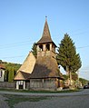
Wooden church in Troița
.jpg)
.jpg)
.jpg)
.jpg)


.jpg)

Personalities
- Mihály Szentiváni (1813–1842) was a politician and writer.
Web links
Individual evidence
- ↑ 2011 census in Romania ( MS Excel ; 1.3 MB)
- ↑ Arcanum Kézikönyvtár: Historical-administrative book of place names of Transylvania, Banat and Partium. Retrieved May 15, 2018 (Hungarian).
- ↑ Trecerile la nivel cu soseaua E60 din Ungheni si Acatari au fost desfiintate at transira.ro, accessed on May 25, 2018 (Romanian)
- ↑ a b c Heinz Heltmann, Gustav Servatius (ed.): Travel Guide Siebenbürgen . Kraft, Würzburg 1993, ISBN 3-8083-2019-2 , p. 517 .
- ↑ Institute Of Archeology - Sânvăsii , accessed on May 25, 2018 (Romanian).
- ↑ Institute Of Archeology - Găleşti , accessed on May 25, 2018 (Romanian).
- ↑ Censuses 1850–2002, last updated November 2, 2008 (PDF; 1 MB; Hungarian)
- ↑ a b c d List of historical monuments of the Romanian Ministry of Culture, updated 2015 (PDF; 12.7 MB; Romanian)
- ↑ Information on churches of different denominations at biserici.org, accessed on May 26, 2018 (Romanian)
- ↑ Information on the Unitarian Church in Maiad at biserici.org, accessed on May 26, 2018 (Romanian)
- ↑ Information on the Unitarian Church in Sânvăsii at biserici.org, accessed on May 26, 2018 (Romanian)
- ↑ Information on the Reformed Church in Bedeni at biserici.org, accessed on May 26, 2018 (Romanian)
- ↑ Information on Mihály Szentiváni at mek.oszk.hu/ accessed on May 15, 2018 (Hungarian)
Acățari | Adămuș | Albeşti | Aluniș | Apold | Ațintiș | Băgaciu | Bahnea | Băla | Bălăușeri | Band | Batoș | Beica de Jos | Bereni | Bichiș | Bogata | Brâncoveneşti | Breaza | Ceuașu de Câmpie | Chețani | Chiheru de Jos | Coroisânmărtin | Corunca | Cozma | Crăciuneşti | Crăiești | Cristești | Cucerdea | Cuci | Daneș | Deda | Hermit | Ernei | Fântânele | Fărăgău | Gălești | Găneşti | Gheorghe Doja | Ghindari | Glodeni | Gorneşti | Grebenișu de Câmpie | Gurghiu | Hodac | Hodoșa | Ibăneşti | Iclănzel | Ideciu de Jos | Livezeni | Lunca | Lunca Bradului | Măgherani | Mica | Miheșu de Câmpie | Nadeș | Neaua | Ogra | Pănet | Papiu Ilarian | Păsăreni | Petelea | Pogăceaua | Râciu | Răstolița | Rușii-Munți | Sâncraiu de Mureș | Sângeorgiu de Mureș | Singer | Sânpaul | Sânpetru de Câmpie | Sântana de Mureș | Saschiz | Sărățeni | Șăulia | Șincai | Solovăstru | Stânceni | Suplac | Suseni | Tăureni | Valea Largă | Vânători | Vărgata | Vătava | Vețca | Viișoara | Voivodeni | Zagăr | Zau de Câmpie