
Vărgata
|
Vărgata Csíkfalva |
|||||
|
|||||
| Basic data | |||||
|---|---|---|---|---|---|
| State : |
|
||||
| Historical region : | Transylvania | ||||
| Circle : | Mureș | ||||
| Coordinates : | 46 ° 35 ' N , 24 ° 48' E | ||||
| Time zone : | EET ( UTC +2) | ||||
| Height : | 370 m | ||||
| Area : | 40.33 km² | ||||
| Residents : | 1,945 (October 20, 2011) | ||||
| Population density : | 48 inhabitants per km² | ||||
| Postal code : | 547625 | ||||
| Telephone code : | (+40) 02 65 | ||||
| License plate : | MS | ||||
| Structure and administration (as of 2016) | |||||
| Community type : | local community | ||||
| Structure : | Vărgata, Grâuşorul , Mitreşti , Vadu , Valea | ||||
| Mayor : | István Balogh ( UDMR ) | ||||
| Postal address : | Str. Principală, no. 34A loc. Vărgata, jud. Mureș, RO-547625 |
||||
| Website : | |||||


Vărgata [ ˈwərgata ] (outdated Cicfalău ; Hungarian Csíkfalva ) is a municipality in Mureș County , in the Transylvania region in Romania .
The place was first mentioned in 1921 under the name Vărgata .
Geographical location

The municipality of Vărgata is located north of the Kokel Valley (Podișul Târnavelor) in the Transylvanian Basin . In the Szeklerland (Ținutul Secuiesc) on the brook Hodoș , a right tributary of the Niraj , and the county road (Drum județean) DJ 135A, the place Vărgata is 6 kilometers north of the small town Miercurea Nirajului (Sereda) and 30 kilometers (approx. 17 km as the crow flies ) to the east of the district capital Târgu Mureș (Neumarkt am Mieresch) .
Until about 2010 a narrow-gauge railway operated on the area of the municipality of the original narrow-gauge line from Cristeşti to the small spa town of Sovata (Szováta) .
history
The place Vărgata founded by Szekler , was first mentioned in 1408. No information can be found about an earlier settlement of the community area, except that a Roman road on the area of the community through all incorporated villages - here also called Drumul lui Traian - except the village of Valea (Hungarian Jobbágyfalva ), to the village of Călugăreni (Mikháza ) of today's Eremitu community .
In the Kingdom of Hungary , today's municipality belonged to the Nyáradszereda chair district in Maros-Torda County , then to the historical Mureș District and, from 1950, today's Mureș District.
population
The population of the municipality of Vărgata developed as follows:
| census | Ethnic composition | ||||
|---|---|---|---|---|---|
| year | population | Romanians | Hungary | German | other |
| 1850 | 1.921 | 196 | 1,659 | - | 66 |
| 1900 | 2,806 | 3 | 2,770 | 10 | 23 |
| 1941 | 3,025 | 13 | 2,955 | - | 57 |
| 2002 | 2,004 | 7th | 1,778 | - | 219 |
| 2011 | 1,945 | 11 | 1,577 | - | 357 |
Since 1850 the area of today's municipality had the highest number of inhabitants and at the same time that of the Magyars in 1941. The highest population of Romanians (403) was determined in 1920, that of Roma (279) in 2011 and that of Romanian Germans in 1900.
Attractions
- In the incorporated village of Mitreşti (Hungarian Nyárádszentmárton ) the Unitarian church , built in the 18th in place of an old one from the 13th century, is a listed building. The church was set on fire by the Turks in 1661, and a new coffered ceiling was installed in 1667 . The church tower with the four turrets was built by Transylvanian Saxons from 1698 to 1702 . There are gravestones from 1798 in the church wall.
- In the incorporated village of Valea a wooden church from 1999, built in place of one in the 17th century and burned down in 1990.
- The Roman path in the incorporated villages of Grâușorul (Búzaháza) and Valea, at the end of the 2nd and beginning of the 3rd century, is a listed building.
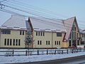
town hall

Unitarian Church in Mitreşti

Wooden church in Valea

.jpg)

Town twinning
The municipality of Vărgata has had partnerships with the Hungarian villages of Rábakecöl in Kapuvár County since 2002 and with Kakasd (German: Kockers ) from the small area of Bonyhád since 2013. The municipality has maintained friendly relationships with the Belgian municipality of Holsbeek since 2008 and the incorporated village of Mitrești has been in existence since 1989 "Adopted" by the French region of Burgundy .
Web links
Individual evidence
- ↑ 2011 census in Romania ( MS Excel ; 1.3 MB)
- ↑ Arcanum Kézikönyvtár: Historical-administrative book of place names of Transylvania, Banat and Partium. Retrieved May 15, 2018 (Hungarian).
- ↑ Trecerile la nivel cu soseaua E60 din Ungheni si Acatari au fost desfiintate at transira.ro, accessed on May 25, 2018 (Romanian)
- ↑ a b Heinz Heltmann, Gustav Servatius (Ed.): Travel Guide Siebenbürgen . Kraft, Würzburg 1993, ISBN 3-8083-2019-2 , p. 517 .
- ↑ Institute Of Archeology - Vărgata , accessed on June 1, 2018 (Romanian).
- ↑ Censuses 1850–2002, last updated November 2, 2008 (PDF; 1 MB; Hungarian)
- ↑ Information on the Unitarian Church in Mitreşti at biserici.org, accessed on June 1, 2018 (Romanian)
- ↑ a b List of historical monuments of the Romanian Ministry of Culture, updated 2015 (PDF; 12.7 MB; Romanian)
- ↑ Information on the wooden church in Valea at biserici.org, accessed on June 1, 2018 (Romanian)
- ↑ Gemeente Holsbeek: Vargata, SOS Roemenië-Comité (ADR). www.holsbeek.be, accessed June 1, 2018 (Dutch).
- ↑ Vărgata municipality: Localități înfrățite. ms.ovelo.ro/vargata, accessed June 1, 2018 (Romanian).
Acățari | Adămuș | Albeşti | Aluniș | Apold | Ațintiș | Băgaciu | Bahnea | Băla | Bălăușeri | Band | Batoș | Beica de Jos | Bereni | Bichiș | Bogata | Brâncoveneşti | Breaza | Ceuașu de Câmpie | Chețani | Chiheru de Jos | Coroisânmărtin | Corunca | Cozma | Crăciuneşti | Crăiești | Cristești | Cucerdea | Cuci | Daneș | Deda | Hermit | Ernei | Fântânele | Fărăgău | Gălești | Găneşti | Gheorghe Doja | Ghindari | Glodeni | Gorneşti | Grebenișu de Câmpie | Gurghiu | Hodac | Hodoșa | Ibăneşti | Iclănzel | Ideciu de Jos | Livezeni | Lunca | Lunca Bradului | Măgherani | Mica | Miheșu de Câmpie | Nadeș | Neaua | Ogra | Pănet | Papiu Ilarian | Păsăreni | Petelea | Pogăceaua | Râciu | Răstolița | Rușii-Munți | Sâncraiu de Mureș | Sângeorgiu de Mureș | Singer | Sânpaul | Sânpetru de Câmpie | Sântana de Mureș | Saschiz | Sărățeni | Șăulia | Șincai | Solovăstru | Stânceni | Suplac | Suseni | Tăureni | Valea Largă | Vânători | Vărgata | Vătava | Vețca | Viișoara | Voivodeni | Zagăr | Zau de Câmpie