Chețani
|
Chețani Maroskece |
||||
|
||||
| Basic data | ||||
|---|---|---|---|---|
| State : |
|
|||
| Historical region : | Transylvania | |||
| Circle : | Mureș | |||
| Coordinates : | 46 ° 28 ' N , 24 ° 2' E | |||
| Time zone : | EET ( UTC +2) | |||
| Height : | 279 m | |||
| Area : | 55.35 km² | |||
| Residents : | 2,665 (October 20, 2011) | |||
| Population density : | 48 inhabitants per km² | |||
| Postal code : | 547150 | |||
| Telephone code : | (+40) 02 65 | |||
| License plate : | MS | |||
| Structure and administration (as of 2016) | ||||
| Community type : | local community | |||
| Structure : | Chețani, Coasta Grindului , Cordoș , Giurgiș , Grindeni , Hădăreni , Linț | |||
| Mayor : | Emil-Florin Mocan ( UNPR ) | |||
| Postal address : | Str. Principală, no. 51 loc. Chețani, jud. Mureș, RO-547150 |
|||
| Website : | ||||
Chețani [ ceˈt͡sanʲ ] (outdated Murăș-Cheța or Cheța ; Hungarian Maroskece or Kece ) is a municipality in the Mureș County , in the Transylvania region in Romania .
Geographical location
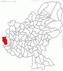
The community Chețani is located in the Transylvanian Basin in the west of the Mureș district. At the confluence of the Chindeni brook into the Mureș (Mieresch) , the national road 15 and the Alba Iulia – Târgu Mureș railway line , Chețani is seven kilometers west of the small town of Luduș (Ludasch) and about 50 kilometers west of the district capital of Târgu Mureș ( Neumarkt am Mieresch) away.
The planned Romanian A3 , also known as Autostrada Transilvania , is to run around three kilometers north of Chețani .
history
The place Chețani, in the Middle Ages a Romanian serf village of today's village Luncani (Neusatz) of the municipality Luna (Lone) , was first mentioned in a document in 1424 or 1444 according to different sources. The place was a manor of the Hungarian noble family Apafi later the family Korda . The castle of the noble family, in which several Transylvanian diets were held in the Middle Ages, was demolished; is known as Cordăteși .
Archaeological finds in the area of the community center indicate that the community area was settled in Roman times ; In the register of historical monuments of the Ministry of Culture and National Heritage (Ministerul Culturii și Patrimoniului Național) finds are assigned to the Copper Age . In the incorporated village of Grindeni (Hungarian Gerendkeresztúr ) archaeological finds of the early history and the Neolithic age were assigned and in Hădăreni (Hungarian Hadrév ) a Roman road is noted.
In the Kingdom of Hungary , the places of today's municipality belonged to the Marosludas chair district in the Torda-Aranyos County , then to the historical Turda district and from 1950 to the present Mureș district.
According to a plan from 2017, the drinking and sewage network , a sewage treatment plant , around six kilometers of roads and a medical center are to be paved in the municipality by 2020 .
population
The population of Che Gemeindeani municipality developed as follows:
| census | Ethnic composition | ||||
|---|---|---|---|---|---|
| year | population | Romanians | Hungary | German | other |
| 1850 | 2,501 | 1,770 | 580 | - | 151 |
| 1920 | 3,209 | 2,451 | 715 | - | 43 |
| 1941 | 4.126 | 3,295 | 784 | 1 | 46 |
| 2002 | 2,889 | 2,352 | 422 | - | 115 |
| 2011 | 2,665 | 2.163 | 347 | - | 155 |
The highest number of inhabitants has been recorded in the area of today's municipality since 1850 and that of the Romanians in 1941. The highest number of Magyars (885) was registered in 1910, Roma (151) in 1850 and that of Romanian Germans (13) in 1890.
Attractions
- In the community center the wooden church Sf. Arhanghel și Gavril (Archangels Michael and Gabriel) built in the 18th century, renovated in 1967, is a Greek Catholic church and is a listed building.
- In the incorporated village of Grindeni, the Greek Catholic wooden church Sfinții Arhangheli , Sfântul Ioan Botezătorul or Sfântul Vasile cel Mare , built according to various statements in the 18th century or 1865, is a listed building.
- In the incorporated village of Hădăreni the Orthodox Church Sf. Arhanghel și Gavril built in 1910 and the Reformed Church built in the 16th century, was originally a Roman Catholic Church .
Web links
Individual evidence
- ↑ 2011 census in Romania ( MS Excel ; 1.3 MB)
- ↑ Information on the website of the Chețani municipality accessed on July 12, 2019 (Romanian).
- ↑ Heinz Heltmann, Gustav Servatius (Ed.): Travel Guide Siebenbürgen . Kraft, Würzburg 1993, ISBN 3-8083-2019-2 , p. 517 .
- ↑ Information on the website of the Chețani municipality accessed on July 12, 2019 (Romanian).
- ↑ Institute Of Archeology - Cheţani , accessed on 12 Junli 2019 (Romanian).
- ↑ a b c List of historical monuments of the Romanian Ministry of Culture, updated 2015 (PDF; 12.7 MB; Romanian).
- ↑ Institute Of Archeology - Grindeni , accessed on 12 Junli 2019 (Romanian).
- ↑ Institute Of Archeology - Hadareni , accessed on 12 Junli 2019 (Romanian).
- ↑ Information on the website of the Chețani municipality accessed on July 12, 2019 (Romanian).
- ↑ Censuses 1850–2002, last updated November 2, 2008 (PDF; 1 MB; Hungarian).
- ↑ Information on the Greek Catholic wooden church in Chețani from biserici.org accessed on June 12, 2019 (Romanian).
- ↑ Information on the Greek Catholic wooden church in Grindeni at biserici.org accessed on June 12, 2019 (Romanian).
- ↑ Information on the Orthodox Church in Hădăreni at biserici.org accessed on June 12, 2019 (Romanian).
- ↑ Information on the Reformed Church in Hădăreni at biserici.org accessed on June 12, 2019 (Romanian).


