
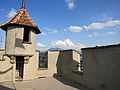
Männliturm
|
Männliturm
|
||||
|---|---|---|---|---|
 |
||||
| Basic data | ||||
| Place: | Lucerne | |||
| Canton: | Lucerne | |||
| Country: | Switzerland | |||
| Altitude : | 476 m | |||
| Coordinates: 47 ° 3 '12.6 " N , 8 ° 18' 2.7" E ; CH1903: six hundred sixty-five thousand five hundred and four / two hundred eleven thousand seven hundred and forty-four | ||||
| Use: | Observation tower | |||
| Accessibility: | Observation tower open to the public | |||
| Tower data | ||||
| Construction time : | circa 1400 | |||
| Building material : | stone | |||
| Total height : | 33 m | |||
| Viewing platform: | 30 m | |||
| Position map | ||||
|
||||


The Männliturm is one of nine towers of Museggmauer in the city of Lucerne . It is located between the Nölliturm and the Luegisland Tower. The tower is named after the "iron man", a half-length figure of a two-meter-high warrior in armor with a flag and sword. This forms the top of one of the two oriel turrets in the battlements.
The building is 33 meters high, making it the third tallest tower in the Musegg Wall. 125 steps lead to the viewing platform at a height of approx. 30 meters. This offers a panoramic view of the city of Lucerne to Lake Lucerne the Reuss and the Pilatus .

Staircase in the Männliturm
Viewing platform
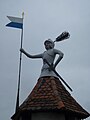
The «iron man»


history
The tower was built in the 15th century. From 1847 until after the Second World War the tower was used for military purposes.
The tower has been open to the public since 1978.

Web links
- Männliturm , on the website of the Association for the Preservation of the Musegg Wall
Maple Tower | Old Church Lungern | Glacier Garden Tower | Hammetschwand lift | Kastelen castle ruins | Lieli | Männliturm | Melchsee-Frutt Panorama Lift | Reuss Delta Tower | Rigi transmission tower | Schirmerturm | Carving tower | Schwanderturm | Animal park tower | Türmli | Wauwilermoosturm | Wissifluhturm | Zytturm