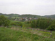
Mirkov
| Mirkov | ||||
|---|---|---|---|---|
|
||||
| Basic data | ||||
| State : |
|
|||
| Region : | Ústecký kraj | |||
| District : | Ústí nad Labem | |||
| Municipality : | Povrly | |||
| Area : | 438.6295 ha | |||
| Geographic location : | 50 ° 42 ' N , 14 ° 7' E | |||
| Height: | 360 m nm | |||
| Residents : | 80 (2001) | |||
| Postal code : | 403 32 | |||
| License plate : | U | |||
Mírkov (German Mörkau ) is a district of Povrly in the Czech Republic . It is located six kilometers northeast of Ústí nad Labem in the Bohemian Central Uplands on the left Elbe .
Geographical location
The neighboring towns are Lipová ( Spansdorf ) and Slavošov ( Slabisch ) in the north, Ryjice ( Reindlitz ) in the east and Neštěmice ( Nestomitz ) and Mojžíř ( Mosern ) in the south. Immediately to the north rises the Blansko ( Blankenstein ) with its striking castle ruins. On the shoulder of the mountain lies the single-layer forester farmer .
history
Mírkov was first mentioned in 1411 as Mierkow . The place was probably founded in the 13th century in connection with the colonization of the area. Until the abolition of patrimonial rule in 1848, the place was part of the allodial dominions Priesnitz and Schöbritz.
With the advent of tourism, Mörkau also had a modest amount of tourism. The destination of the hikers and day trippers was in particular the Blankenstein ruins, but also Mörkau chapel and the Schuwenze. The (now defunct) inn "Zur Sandsteinkapelle" offered the tourists food and accommodation.
After the Sudetenland was annexed to Germany on October 1, 1939, Mörkau belonged to the German district of Aussig . In 1939 there were 249 inhabitants in Mörkau.
After the Second World War , Mörkau returned to Czechoslovakia on May 9, 1945. By 1946, the majority of the German-speaking residents had been expelled. Since then, only the Czech version of Mírkov has been the official place name . Later the place was repopulated with Czech-speaking citizens.
In 2001 Mírkov had 74 inhabitants. Six more lived in Blansko.
Local division
- Dolní Mírkov ( Tittelsbach )
- Blansko ( Blankenstein )
Attractions
- Chapel on the village square, built in 1800
- Blansko castle ruins with the forester builder
- former Mörkau chapel
literature
- Jiří Souček: Obrazová rukověť obcí a církevních staveb v okrese Ústí nad Labem. Albis international, Ústí nad Labem 1999, ISBN 80-86067-41-6 .
Web links
Individual evidence
- ↑ http://www.uir.cz/katastralni-uzemi/726796/Mirkov
- ^ Ferdinand W. Kirsch: Bohemian Central Mountains. Western part. From the Elbe Mountains to the Ore Mountains (= Meinhold's route guide . 10, ZDB -ID 842930-3 ). 2nd Edition. CC Meinhold & Sons, Dresden 1928.
- ↑ Michael Rademacher: German administrative history from the unification of the empire in 1871 to the reunification in 1990. Aussig district. (Online material for the dissertation, Osnabrück 2006).
- ↑ Data from the Statistical Office of the Czech Republic


