Mainbach (Rednitz)
| Mainbach | ||
|
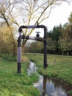
The Mainbach near Rednitzhembach with the work of art Lichtvier (2012) |
||
| Data | ||
| Water code | DE : 2421552 | |
| location |
Middle Franconian basin
|
|
| River system | Rhine | |
| Drain over | Rednitz → Regnitz → Main → Rhine → North Sea | |
| Supreme source | on the southern edge of Kammerstein - Haag 49 ° 18 ′ 7 ″ N , 10 ° 59 ′ 17 ″ E |
|
| Source height | approx. 368 m above sea level NHN | |
| muzzle | near Untermainbach (Rednitzhembach) from the left (west) into the Rednitz coordinates: 49 ° 17 '52 " N , 11 ° 4' 35" E 49 ° 17 '52 " N , 11 ° 4' 35" E |
|
| Mouth height | approx. 318 m above sea level NHN | |
| Height difference | approx. 50 m | |
| Bottom slope | approx. 7.2 ‰ | |
| length | approx. 6.9 km | |
| Catchment area | approx. 22.4 km² | |
The Mainbach is a small year-round flowing water of the 3rd order , which flows on the northern edge of the Heidenberg in the areas of Kammerstein , Schwabach and Rednitzhembach in the Central Franconian district of Roth in Bavaria and flows into the Rednitz from the left between Plöckendorf and Rednitzhembach.
geography
course
The Mainbach arises in the floodplains on the southern edge of the Kammerstein town of Haag at about 368 m above sea level. NHN , flows over its entire course quite precisely to the east and collects all forest and meadow streams between Kammerstein and Rednitzhembach as receiving water . About 700 meters after its origin, below Haag in the area of half a dozen ponds used for fishing with an area of about 1.2 hectares from the south-west, it takes its 1.3 km longer right source branch, which is about 373 m above sea level. NHN begins its course one kilometer east of Kammerstein on the northern slope of the Heidenberg in the Hölle forest .
Subsequently, the Mainbach strengthen the treated wastewater from the Hague sewage treatment plant. Another two kilometers downhill, it touches the southern outskirts of Obermainbach, crosses state road 2224 , and then flows through some artificially created ponds and the approximately three- hectare mill pond at Weihersmühle . After another 500 meters, the Otterbach flows into Walpersdorf from the right , its largest tributary, which drains the eastern slopes of the Heidenberg. After the confluence of the Main river passes south to Rednitzhembacher district of Lower Main stream , passes under the route of the S-Bahn S2 Roth - Altdorf, flows partially verdolt the eastern part of Lower Main stream and opens out farther 700 meters from the left at an altitude of 318 m above sea level. NHN in the Rednitz.
Catchment area
The Mainbach drains its catchment area around the Heidenberg with an area of about 22.4 km² eastwards to the Rednitz. Four fifths of them are forested.
Tributaries
- (Other source branch), from the right and south-west east of Haag in the area of the fish ponds, approx. 1.3 km and approx. 1.5 km². Arises at about 373 m above sea level. NHN one kilometer east of Kammerstein on the northern slope of the Heidenberg in the Hölle forest .
The Mainbach itself is only about 0.7 km long at the confluence, but contributes about 1.8 km to the catchment area. - Otterbach , from the right and west-southwest in Walpersdorf, approx. 4.6 km with the longest source branch and approx. 6.0 km². Arises at about 414 m above sea level. NHN in the forest of Heidenberg west-southwest of Ungerthal on the Quellensteig .
- (Auengraben), from the right and south just before the mouth, approx. 3.1 km. Inconsistent water-bearing ditch next to the Rednitz.
nature
Water quality
The Mainbach is considered to be critically loaded along the entire course .
fauna
Especially the source area of the right Mainbach source branch is often visited by red deer to drink at dusk. In its lower part it is mainly a refuge for insects, poor amphibians, small crabs, snails and small fish. Occasionally some water-loving small breeding birds can be found in undisturbed locations.
Attractions
- At the upper reaches of the Mainbach, on the Heidenberg , is the 14-kilometer long so-called legend hiking trail . According to tradition, Attila, king of the Huns, has been buried there since 453 AD .
- The Rednitzhembacher Kunstweg can be found in the Rednitzhembacher districts ; in the estuary, for example, Lichtvier (see picture above) and the wave (picture on the right).

