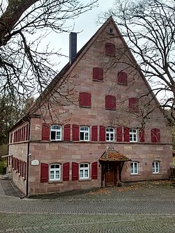
Weihersmühle (Rednitzhembach)
|
Weihersmühle
community Rednitzhembach
Coordinates: 49 ° 17 ′ 57 " N , 11 ° 2 ′ 34" E
|
|
|---|---|
| Height : | 340 m above sea level NHN |
| Residents : | 16 |
| Postal code : | 91126 |
| Area code : | 09122 |
|
Weihersmühle from the north
|
|
Weihersmühle is the westernmost part of the municipality Rednitzhembach in the district of Roth in Middle Franconia ( Bavaria ).
Geographical location
The wasteland is just four kilometers south of Schwabach in the valley of the Mainbach , a left tributary of the Rednitz at an altitude of 338 to 345 m above sea level. NHN . To the north, the terrain rises gently to the extensive Maisenlach forest area , to the west to the 461 m high Heidenberg . To the east the valley opens up to the Rednitzgrund.
history
The fertile valley of the Mainbach was already settled in the Neolithic . A settlement area of around 4.5 hectares is designated as a ground monument 100 meters south of Weihersmühle. In the immediate vicinity there are settlement and burial sites from the Urnfield Period and the Hallstatt Period . At the turn of the times, the area was the southernmost branch of the Narisker settlement area .
The settlement was abandoned in Roman times; the Limes was only a day's march away and times were getting too restless. There are no findings from the time of the Great Migration and only began sporadically again with the Carolingian period.
The economic revival of the area dates back to the 11th and 12th centuries. The structure of the mill from 1796 is still preserved today. In the Bavarian original cadastre from 1808 the mill and its farm buildings are recorded under the name Weyerers-Mühle and another homestead is recorded. Particularly worth mentioning is the Mühlweyher, which was extremely large at three hectares during this period .
Conversions and extensions from the 18th and 19th centuries have been preserved and are now a listed building (see: List of architectural monuments in Weihersmühle ).
today
In addition to the historical building fabric, modern residential developments were built on the agricultural land that had become vacant. The former mill area serves as a dog training area. The surrounding forest and parcels are under landscape protection .
traffic
A municipal road connects Weihersmühle to Rednitzhembach on state road 2409 and to Haag on federal road 466 .
The local public transport does not serve Weihersmühle. In Walpersdorf , 600 m to the east, a regular taxi service can be used; In Rednitzhembach, 2 km away, there is an option to board the S-Bahn line 2 , the VGN . Ottersdorf , 1 km south, is served by line 662 to Schwabach.
literature
- Johann Kaspar Bundschuh : Weihersmühl . In: Geographical Statistical-Topographical Lexicon of Franconia . tape 6 : V-Z . Verlag der Stettinische Buchhandlung, Ulm 1804, DNB 790364328 , OCLC 833753116 , Sp. 125 ( digitized version ).
- Friedrich Eigler : Schwabach (= Historical Atlas of Bavaria, part of Franconia . I, 28). Michael Laßleben, Kallmünz 1990, ISBN 3-7696-9941-6 , p. 431, 487 .
Web links
- Weihersmühle in the location database of the Bavarian State Library Online . Bayerische Staatsbibliothek, accessed on September 23, 2019.
- Weihersmühle in the Topographia Franconiae of the University of Würzburg , accessed on September 23, 2019.
- Weihersmühle in the historical directory of the Verein für Computergenealogie , accessed on September 23, 2019


