
Malaita (province)
| Malaita | |
|---|---|

|
|
| geography | |
| Country: | Solomon Islands |
| Waters: | Pacific Ocean |
| Islands: | Malaita , Maramasike , Ontong Java and Sikaiana |
| Geographical location: | 9 ° 0 ′ S , 160 ° 59 ′ E |
| Basic data | |
| Surface: | 4225 km² |
| Residents: | 137,600 |
| Population density: | 33 inhabitants / km² |
| Capital: | Auki |
| Situation map | |
 .svg) |
|
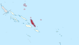
The province of Malaita is located in the center of the Pacific island state of Solomon Islands . It borders on the provinces of Guadalcanal and Central to the west, and on the province of Isabel to the north .
The province mainly includes the island of the same name Malaita , the island of Maramasike and the islets of the remote atolls Ontong Java and Sikaiana as well as the Roncador Reef .
The area of the islands of the province of Malaita amounts to 4,225 km². After the census of 2009 there lived 137,600 people. In the north-west of the main island Malaita (3,885 km²) lies the provincial capital Auki .
structure
|

See also
Individual evidence
Central | Choiseul | Guadalcanal | Isabel | Makira and Ulawa | Malaita | Rennell and Bellona | Temotu | Western | Honiara (capital district)