Karnobat
| Karnobat (Карнобат) | |||
|
|||
| Basic data | |||
|---|---|---|---|
| State : |
|
||
| Oblast : | Burgas | ||
| Residents : | 17,608 (December 31, 2016) | ||
| Coordinates : | 42 ° 39 ′ N , 26 ° 59 ′ E | ||
| Height : | 262 m | ||
| Postal code : | 8400 | ||
| Telephone code : | (+359) 0559 | ||
| License plate : | A. | ||
| administration | |||
| Mayor : | Atanas Atanasov | ||
| Website : | karnobat.acstre.com | ||
Karnobat [ kɐrnoˈbat ] ( bulg . Карнобат ) is a city in southeastern Bulgaria and lies in the Upper Thracian Plain . The city is located in the Burgas Oblast and is the administrative center of the municipality of the same name Karnobat. The distance to the cities of Burgas (56 km), Sliven and Yambol is about the same. Karnobat is the third largest city in Burgas Oblast - after Burgas and Aytos .
location
Karnobat is located in the eastern part of the Thracian Plain , south of the Balkan Mountains in the valley of the same name . The Bakaschizite elevations, which border the Burgas plain in the west, extend southwest of Karnbat .
economy
The European route 773 , which connects Sofia and Burgas, runs through the city. A branch leads to Shumen . The A1 motorway joins the E 773 southwest of Karnobat. Karnobat is one of the largest rail traffic junctions in Bulgaria, connecting southern Bulgaria with northern Bulgaria: in Karnobat, the route to Varna branches off from the Burgas- Sofia railway line .
There is an agricultural institute in the city.
history
Markeli
The medieval fortress Markeli (bulg. Маркели) near the settlement Markeli is 7.6 km west of Karnobat and dates from the 7th – 11th centuries. Century. From the second half of the 8th century to the beginning of the 9th century it was a hub of Bulgarian-Byzantine relations in political and military terms. It secured a junction of the Via Militaris in a north-easterly direction over the mountain passes entrances of the Warbiza and Rischki to the Danube and an easterly direction to the Via Pontica .
On July 20, 792, Khan Kardam (reign 777-802) won the decisive battle of Marcellae at Markeli at the end of the first Byzantine-Bulgarian wars .
Until the second half of the 8th century, Markeli was an important bishopric.
After the victories of Khan Krum , the Byzantine city of Markeli became the largest Bulgarian military camp south of the Balkan Mountains in the eastern part of the Thracian Plain. It was supposed to protect the entrances to the mountain passes, which represent the shortest route across the mountains, and the Bulgarian capital north of the mountains. Huge fortification work was carried out (earth walls, trenches), which today are the best-preserved and largest on the Balkan Peninsula.
Ottoman and modern times
Historical sources show that the city has always been an administrative center, an economic and trade center with an annual fair since the 15th century. It is mentioned in the sources under different names: Karinowasa (Bulgarian Кариноваса), Karinabad (Каринабад) and Karnowo (Карново). During the Bulgarian Revival , the city was a center of “cultural enlightenment”. During this period the city made a significant contribution in the fight against the supremacy of the Greek Orthodox Church. In the 1860s, the citizens of Karnobat chased the Greek church leaders out of the city and thus finally put an end to Greek influence (see Bulgarian Exarchate ).
During the Russo-Turkish War (1877–1878) , the region fell victim to marauding Turkish militants ( Başı Bozuk ) and Circassians . On January 24, 1878, the 500-year Turkish rule over the city ended.
The city has given its name to the Karnobat Pass , a mountain pass on Livingston Island in Antarctica , since 2005 .
Attractions
- the church Sweti Joan Bogoslow (Bulgar. Свети Йоан Богослов) built in 1878 by the builder Gentscho Kalew - an even older church was burned down here on January 1st, 1878 by the Turks. The iconostasis was carved by masters of the Debar school
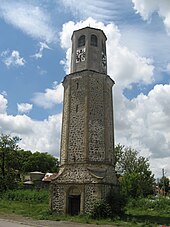
- the clock tower, built in 1874 as a symbol of economic prosperity during the Bulgarian Revival period
- the Sinabey Haman ( Oriental Bath ) in the old town, built in the 15th century, one of the best preserved of its kind in southern Bulgaria,
- the Black Mosque (bulg. Черната джамия), built in 1821,
- the Jewish cemetery


