Primorsko
| Primorsko (Приморско) | ||||
|
||||
| Basic data | ||||
|---|---|---|---|---|
| State : |
|
|||
| Oblast : | Burgas | |||
| Residents : | 2966 (December 31, 2016) | |||
| Coordinates : | 42 ° 16 ' N , 27 ° 46' E | |||
| Height : | 0 m | |||
| Postal code : | 8180 | |||
| Telephone code : | (+359) 0550 | |||
| License plate : | A. | |||
| Administration (as of 2011) | ||||
| Mayor : | Dimitar Germanov | |||
| Ruling party : | GERB | |||
| Website : | www.primorsko.bg | |||
Primorsko ( Bulgarian Приморско ) is a city and administrative center of a municipality of the same name in southeastern Bulgaria , in Burgas Oblast . It has a small port and is known for tourism. Primorsko (translated: lying by the sea) is around 50 km from Burgas .
geography
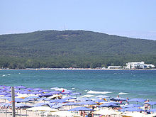
The city is located in the eastern part of the historical Thrace landscape on a small rocky peninsula between the bays of Stomopolo and Djavolski Saliv. It developed at the mouth of the Djawolska River on the Black Sea at the foothills of the Strandscha Mountains . Primorsko (German: By the sea ) is a seaside resort with a particularly good climate, because the temperate continental and subtropical climatic zones meet here. It is located about 25 km south of Sozopol and 52 km south of Burgas .
Community structure
The Primorsko municipality (Bulgarian Община Приморско) includes the towns of Primorsko and Kiten as well as the villages of Wesselie , Novo Panicharevo , Pismenowo , and Yasna Polyana . The municipality borders the Black Sea in the east, the Sozopol municipality in the west and north and the Zarewo and Malko Tarnowo municipalities in the south . The entire municipality has 6714 inhabitants.
The municipality was founded according to the will of the people of Primorsko, Pismenowo, Yasna Polyana and Novo Panicharevo after a referendum in 1997. The places Kiten (2001) and Weselie (2004) joined the community through later referendums.
history
The first evidence of settlement in the region comes from Thracians from the 13th and 14th centuries BC. In the area the typical Thracian dolmens were discovered during excavations . The remains of the Beglik Tash sanctuary and the Ranuli citadel on Mount Kitka, on the right bank of the Ropotamo River, also date from the time of the Thracians . Historians suspect that the region was either incorporated into the Greek city-state Apollonia Pontica or the Thracian Odrysenic Empire during this period . Around the first century BC The region was conquered by the Romans .
Primorsko was initially an inconspicuous village and was called Tschenger during the Ottoman rule . The extensive settlement of the city did not begin until 1879, when Bulgarian refugees from Thrace settled near the Bulgarian border and founded the village of Kjuprija (Bulgarian Кюприя). The small village was incorporated into the Bulgarian state during the Balkan Wars (1912-1913). In the following time, more Thracian Bulgarians settled here. In 1934 the name was changed to Primorsko. The port was opened in 1939. Primorsko has been a national health resort since 1962 and a city since 1981.
Tourism is an important economic factor in the region. In the 1970s and 1980s, more than 80 company holiday homes were built along and in the immediate vicinity of the sandy beach. Most of them were privatized in the 1990s and 2000s. In addition, Primorsko has become a center for international youth tourism, there are summer camps for schoolchildren and students and a large campsite. A largely preserved forest area with old beech trees at the foot of the mountains also offers good hiking opportunities.
Attractions
- Rest of the ancient city of Ranuli
- Maslen fortress nos
- Cape Maslen nos
- Beglik Tash
- Sveti Toma Island
- Alepu Nature Reserve
- Arkutino nature reserve
- Ropotamo Conservation Complex
- Residence Perla
- Strandscha Nature Park
- Sweta Paraskewa chapel on the cape of the same name


