Marienburger Höhe
The Marienburger Höhe is a district in the southeast of Hildesheim , in which the University of Hildesheim is located.
|
Marienburger Höhe
City of Hildesheim
Coordinates: 52 ° 8 ′ 7 ″ N , 9 ° 58 ′ 8 ″ E
|
|
|---|---|
| Postal code : | 31141 |
| Area code : | 05121 |
|
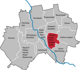
Location of the Marienburger Höhe and the Galgenberg in Hildesheim
|
|
geography
The Marienburger Höhe district extends in the south-east of Hildesheim on both sides of Marienburger Strasse in a north to north-east and south to south-west direction. On Marienburger Strasse, at the level of the Schneidemühler Strasse junction, a sign indicates the beginning of the district. The distance to the city center is around 3 km.
The district is bounded in the west by the Hildesheim – Goslar railway line . Here is at almost 90 m above sea level. d. M. the lowest part of the Marienburger Höhe. In the east of the district the terrain rises considerably and in the area of Stettiner and Neidenburger Strasse reaches a height of up to 130 m above sea level. The 164 m high forested Galgenberg forms the eastern boundary of the district . In the south, the district is separated from the Itzum district by the Südfriedhof .
The Marienburger Höhe together with the Galgenbergviertel form the locality "Marienburger Höhe mit dem Galgenberg" with its own local council of 11 members. As of December 31, 2019, 9,410 people lived there on an area of 426 ha .
history
When the population of Hildesheim rose sharply during the founding period , the non-profit construction company Hildesheim was founded in 1892 to create affordable housing for low-income citizens. In 1902 she had the first houses built in what is now the Marienburger Höhe district in the area of Scharnhorststrasse, Körnerstrasse and Blücherstrasse. Shortly afterwards, Schillstrasse, so named in 1904, and Gneisenaustrasse, which were named in 1907, were created. The buildings were relatively simple one and two-family houses for large families in the style of that time. It was certainly no coincidence that they were deliberately built outside of the then built-up urban area - around 1900 Hildesheim only reached as far as Feldstrasse and Struckmannstrasse in the southeast. On Marienburger Strasse, first mentioned under this name in 1870, only a few houses had been built between Goschentor and Quedlinburger Strasse. Most of Hildesheim's residents were suspicious of the new quarter: it was popularly known as “Klemmbutz”, whereby “to clamp” meant nothing else than “steal”.
In the 1930s, the new district expanded to the south: four apartment buildings were built on Marienburger Strasse, which were called “people's apartments”. In addition, south of Stralsunder Straße, which was named in 1931, the Großer Saatner settlement, which was funded with public funds, was built after 1933 from single-family houses with gardens for self-sufficiency for large families. Many of them are still unmistakably preserved today, e.g. B. in the area of Yorckstrasse and Lützowstrasse, Am Pfingstanger, An den Osterstücke and Am Kuhanger.
During the Second World War , during the air raid on Hildesheim on March 3, 1945 at around 10:30 am, bombs fell on the Großer Saatner settlement, possibly related to the railway line that ran further west. Since the outskirts believed they were safe from bombs, many people were not in the basement during the air raid. Several houses were destroyed in the southern section of Yorckstrasse and, above all, Lützowstrasse. A direct hit on the house at Marienburger Strasse 91d killed 9 people, and there were also several deaths in Yorckstrasse and Lützowstrasse.
Until the 1950s, the area east of Marienburger Strasse was still undeveloped. The first multi-family houses between Marienburger and Insterburger Straße were built around 1954 in the style typical of the time. Extensive expansion of the district began in 1964. During this time, numerous single-family houses were built between Ortelsburger and Braunsberger Strasse and, from 1970, the buildings now used by the university. In the mid-1980s, the expansion of the district was practically complete.
politics
The town of Marienburger Höhe / Galgenberg is represented by 11 local council members. Nicole Reuss (SPD) has been the local mayor since May 2018. From 2011 to May 2018, Stefan Gerlach (SPD) was the local mayor.
Culture and sights
On the Marienburger Höhe there are buildings from many different style eras from the beginning to the end of the 20th century. In the oldest streets of the district - Schill-, Scharnhorst-, Blücher-, Körner- and Gneisenaustraße - you will find row houses from the Wilhelminian era , which were built in a deliberately simple style for low-income families. In the twenties, single-family houses were built on larger plots in the streets of Großer Saatner and Am Roten Steine.
Lively construction activity began in the 1930s, when the Großer Saatner settlement with single-family houses with gardens for self-sufficiency for large families was created with public funds. Four striking tenement houses were built on Marienburger Strasse for the same target group, which still stand out clearly from the other residential buildings in the district.
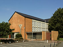
A church was not built in the district until after the Second World War: St. Timotheus was built in 1953.
A not inconsiderable part of the Marienburger Höhe today consists of single-family houses from the 1960s and 1970s. During this time (1964) the Catholic Church of Our Lady was also built. The most striking building is the University of Hildesheim, which was built in the brutalist style from 1965 to 1973 as a pedagogical college . In the immediate vicinity, the community center of the Protestant Matthäusgemeinde was built in 1970 in Braunsberger Strasse by the architect Dieter Oesterlen , also in exposed concrete. The church interior, which was only added in 1987, is a typical example of the architecture of the 1980s.
Economy and Infrastructure
The backbone of the district is the busy Marienburger Strasse. Not only the city bus lines 1, 4, 10 and 104 (evening line from 8:30 p.m.), which connect the district with the city center, main station and other parts of the city, run on it, but also other bus lines that provide the connection between Hildesheim and numerous surrounding villages.
The Hildesheim – Goslar railway line , which runs in a valley below the district and is separated from it by meadows and the Großer Saatner forest , is of no importance for the development of the Marienburger Höhe: the distance to the residential areas is too great to be z. B. it would be worth setting up a stop, and it would be too close to the Ostbahnhof , which is served by two regional lines. Both the Ostbahnhof and the main train station can be easily reached with the Hildesheim city traffic (SVHI).
The Marienburger Platz is geographically almost exactly the center of the district. There are several shops, a supermarket and not far from the University of Hildesheim.
The district has several kindergartens, a day-care center, two elementary schools, a secondary school and a secondary school. The first church in the district was built in 1953, the Protestant Timothy Church, which today houses the University's Center for World Music . The Catholic Church of Our Lady and the Evangelical Church of St. Matthew followed. A large old people's home was built on Ortelsburger Strasse in the 1960s.
The Marienburger Höhe is now a popular residential area with a high recreational value. Several permanent allotment gardens extend in the district. Numerous cycling and hiking trails open up the Großer Saatner forest , the Innerste valley and the forested Galgenberg . Popular excursion destinations such as the Bismarck Tower , the Yellow Tower observatory and the Brockenblick excursion restaurant are within easy walking distance. The Tonkuhle bathing lake is only a few minutes' walk from Marienburger Platz and is very popular in summer.
Web links
- Marienburger Höhe on the website of the city of Hildesheim
Individual evidence
- ↑ a b Main statutes of the city of Hildesheim from 12.12.2011 in the version from 19.12.2016, § 6 (1).
- ↑ Population as of December 31, 2019 (PDF) and city portrait: Marienburger Höhe / Galgenberg, area. Website of the city of Hildesheim, accessed on May 1, 2020.
- ↑ "Healthy, beautiful location" and accessories. In: Nebenan - gbg Mietermagazin. Edition 3, 2017 (= anniversary edition, special issue No. 3), p. 13 ( PDF ).
- ^ Local councilor Marienburger Höhe / Galgenberg. Citizen information system of the city of Hildesheim, accessed on May 1, 2020.
- ^ Friedrich Winterhager: From Alfeld to Hildesheim. From the history of the college of education and the university (1945–2002). In: Wolfgang-Uwe Friedrich and Martin Schreiner (eds.): Seventy years in the service of education. From the Alfeld University of Education to the University of Hildesheim Foundation 1945–2015. Universitätsverlag Hildesheim, 2015, p. 19, available online (PDF).
- ↑ St. Matthew's Church. Evangelical Lutheran Matthäusgemeinde Hildesheim, accessed on May 1, 2020.
- ^ Center for World Music. Foundation University of Hildesheim.


