Oststadt (Hildesheim)
|
East town
City of Hildesheim
Coordinates: 52 ° 9 ′ 19 ″ N , 9 ° 57 ′ 51 ″ E
|
|
|---|---|
| Area : | 4.03 km² |
| Residents : | 14,349 (Dec. 31, 2019) |
| Population density : | 3,561 inhabitants / km² |
| Postal code : | 31135 |
| Area code : | 05121 |
|
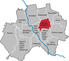
Location of the Oststadt and Stadtfeld in Hildesheim
|
|
The Oststadt (officially: Oststadt including the Stadtfeld ) is a district of Hildesheim that adjoins the Neustadt to the east and emerged from the second half of the 19th century.
geography
The district has an area of around 4.03 km². In addition to the Oststadt in the narrower sense, the Stadtfeld settlement and the Fahrenheit residential area are also included in it. The largest north-south extension of the built-up area (southern end of Sedanstrasse in the south to Fahrenheitstrasse in the north) is around two kilometers, its greatest east-west extension (Kennedydamm in the west to Triftäckerstrasse in the east) 1.7 km.
In 2003, 12,319 people lived in this area. On December 31, 2005 the population was 11,875, including 12.1% with a migrant background.
history
The entire area east of the Sülte in front of the Hildesheim old town was called "Creyenbergh" in the Middle Ages , this field name was mentioned for the first time in a document in 1240. In the Middle Ages, the Katharinenhospital, founded in 1270, a nursing home for lepers and other sick people, as well as the Katharinenkirchhof, which was used from 1321–1850, and the stone pit, a quarry mentioned in 1324, were located here. It also served as a place of execution for the burning of witches and other executions. In the area of today's Teichstrasse was the Jewish cemetery, which still exists today, as well as a pond called "Judenteich".
Decisive for the development of the Oststadt were the demolition of the medieval city fortifications of Hildesheim as well as the construction of the railway and the Ostbahnhof : Around 1810 the rampart and ditch between Friesentor and Ostertor, the two city gates in the eastern area of Hildesheim's old town, were demolished and a street in their place created, which was named "Zingel" and was built from 1868 on. The wall between today's Hindenburgplatz and the Braunschweiger Tor along today's Goslarschen Strasse was leveled in 1825. The wall between Braunschweiger Tor and Goschentor was removed in 1819–1820 and the moat was not filled in until 1866; Sedanstraße was built here from 1873 onwards. The so-called “sand ditch” between Braunschweiger and Ostertor was also filled in in 1866, and Gartenstraße was laid out in its place in 1872. Nothing stood in the way of Hildesheim's expansion to the east.
The side streets of Goslarschen and Sedanstraße were the first to emerge. At the beginning of Goslarschen Strasse, the Andreanum grammar school was built in 1865–1869 and the secondary school for daughters opened in 1876, which was later renamed the “Goetheschule”. The Wörthstrasse was laid out in 1876 as an access road from Hildesheim Neustadt to the newly opened Ostbahnhof.
An important impetus for the development of the Oststadt was the construction of the stone pit barracks (1874–1876) at the stone pit, which was leveled and served as a parade ground. The barracks was on Moltkestrasse south of today's Eichendorffstrasse, which was originally called "Kasernenstrasse".
Until 1899, Einumer Straße, which already existed in the Middle Ages as a trade route leading to Braunschweig , formed the northern boundary of the eastern part of the city. After 1899, Katharinenstrasse, Moltkestrasse and Orleanstrasse were extended to the north. Because of the strong increase in population, the building of new churches became necessary. St. Elisabeth's Church was built in 1905-07 by master builder Richard Herzig . A Protestant church was not rebuilt for the eastern part of the city, the existing parishes in Hildesheim expanded their parish districts in line with the growth of the new district. At the edge of the stone pit, a restaurant was opened in 1873, which had a hall for theater performances. The city theater was built on the property in 1908-09.
In contrast to the old and new towns, the eastern part of the city was spared extensive damage during the Second World War , although it was affected several times by air raids on Hildesheim . On February 22, 1945, the area around Altenbekener and Gravelottestrasse and the area between Goslarscher Strasse and Steingrube were hit by bombs. On March 3, 1945, damage occurred in particular between Gartenstrasse and Zingel, on the Sülte and the theater, in Eichendorffstrasse and Orleansstrasse. In the last and heaviest air raid on Hildesheim on March 22, 1945, the Oststadt was hit again. Were destroyed u. a. the stone pit barracks , the Goethe School and the Andreanum grammar school . The theater became strong, other buildings such as St. Elisabeth's Church, Waterloo Barracks and Ostbahnhof were only slightly damaged or remained completely intact.
The Stadtfeld settlement was built from 1921 on what is now Bundesstraße 1 , while the Fahrenheit residential area was created in the 1950s.
politics
The Oststadt local council has eleven members.
The local mayor is Helmut Borrmann (SPD).
Culture and sights
Theaters and museums
The theater for Lower Saxony is located in the former city theater, which was inaugurated in 1909. It is connected to the Thega-Filmpalast , a cinema with over 1150 seats.
Buildings
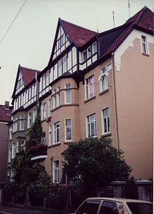
Due to the relatively minor damage that the eastern city suffered in World War II, you can find residential and commercial buildings in the style of classicism , historicism and the Wilhelminian era with towers, bay windows and richly decorated facades. Buildings from these eras can be seen in Sedanstrasse, Immengarten, Goethe, Lessing or Schillerstrasse. Numerous brick buildings of the lower-income sections of the population typical of the time have been preserved, for example in Augusta, Kamp and Weißenburger Strasse.
The most striking buildings in the east of the city are the Catholic Church of St. Elisabeth, completed by Richard Herzig in the neo-Romanesque style in 1907, with its two towers on Moltkestrasse that can be seen from afar, and the theater on Theaterstrasse, which was inaugurated in 1909.
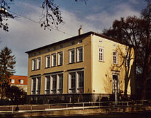
The merchant Conrad Lindemann had the villa named after him built on the corner of the corner of Bahnhofsallee in the classicism style. It was acquired in 1872 by the neighboring "sanatorium and nursing home" and has served as a music school since 1979. The house at Moltkestraße 9, built in 1885 as the home of the cathedral builder Richard Herzig (1851–1934), is an example of historicism . According to Herzig's plans, St. Bernward in the city center and St. Elisabeth in the eastern part of the city were built in Hildesheim, and a total of 21 churches in the Hildesheim diocese between 1885 and 1913.
One of Hildesheim's two Jewish cemeteries is located on Teichstrasse and is 1,841 m² in size. The oldest graves date from the beginning of the 18th century. During the Second World War he was spared bomb damage.
The Catholic Church Guter Hirt was built in the Fahrenheit area in 1969/70 , which is best known for its affiliated social lunch menu .
Green spaces and recreation
The local recreation area Galgenberg with an excursion restaurant and the Bismarck Tower , a lookout tower built in 1905, extends in the immediate vicinity of the Oststadt . The “Steingrube” green space, which is used for various purposes, extends in the middle of the district.
Economy and Infrastructure
Companies
In the area of Einumer Strasse and Moltkestrasse there are numerous retail stores, craft and other service businesses, in Gravelottestrasse and Frankenstrasse there are grocery stores.
After the Ledebur barracks on Bundesstrasse 6 were demolished , the new Hildesheim Clinic moved in its place in September 2011. The Medicinum Medical Center was opened in April 2009.
education
In the Oststadt are:
- seven kindergartens
- three day nurseries
- two day nurseries
- two elementary schools
- a high school
- a music school
traffic
The Hildesheim – Goslar railway with the Hildesheim Ost train station built in 1875 runs through the eastern part of the city . The main station is not more than three kilometers away from any street in the district and is connected to Oststadt via the city bus line 3. The market square and pedestrian zone in the city center are easy to reach on foot from many streets due to the short distance. In the northern part of the federal highway 1 runs, which is less than 2 km to the “Hildesheim” motorway junction of the A 7 motorway, which was completed in 1960 .
The Hildesheim tram served the Oststadt from 1907 to 1945 on three lines. Today, the district is served by several city bus routes: Line 3 travels through the eastern part of the city in a north-south direction and provides the connection to the main station and the University of Hildesheim as well as to other parts of the city. Lines 4 and 5 run in an east-west direction and connect the Oststadt with the city center, the Stadtfeld settlement, other parts of the city and with the university.
literature
Meier-Hilbert, Gerhard: The Hildesheimer Oststadt - geographical structures of a district. - In: Hildesheimerjahrbuch 82 (2010), pages 179–227. Hildesheim: Gerstenberg 2010.
Web links
Individual evidence
- ↑ http://www.hildesheim.de/pics/verwaltung/1_1425647857/Broschuere_2014_OPT.pdf p. 8
- ↑ Population of the city of Hildesheim as of December 31, 2019. In: hildesheim.de. Hildesheim Marketing GmbH, accessed on June 3, 2020 .
- ^ Local council Hildesheim Oststadt


