
Itzum
|
Itzum
City of Hildesheim
|
|
|---|---|
 |
|
| Height : | 83 m |
| Residents : | 7979 (Dec. 31, 2019) |
| Incorporation : | March 1, 1974 |
| Postal code : | 31141 |
| Primaries : | 05121, 05064 |
With around 8000 inhabitants, Itzum is one of the largest districts of Hildesheim and extends on the southern slopes of the Galgenberg in the southeast of the city.
history
The district was named after the village of Itzum, first mentioned in a document in 1372, which was an independent municipality until 1974 and was then incorporated into Hildesheim together with seven other villages.
With its fertile loess soil, Itzum was shaped by agriculture and the Catholic Church. In the coat of arms of the village, which had only 330 inhabitants in 1895, St. George is depicted as a dragon slayer.
As part of the regional reform in Lower Saxony , Itzum was incorporated into Hildesheim on March 1, 1974. On the reporting date, Itzum had around 1,100 residents, around 300 of whom commuted to work in Hildesheim, 5 km away, every day. Between the outskirts of Itzum and the "Marienburger Höhe", the closest district of Hildesheim, there were agricultural areas. The city intended to create living space for around 4,000 people on this 45 hectare area in a hilly landscape with a view of the Innerste Valley . From 1982 lively construction activity began in the area between the old village of Itzum and Hildesheim, so that a new district was created under the name of the old village of Itzum.
The old town center of Itzum and Hildesheim form a closed settlement area. The expansion of the district has not yet been completed, but has reached its limits with the development of the Hohe Rode and Wasserkamp building areas, which is not undisputed among the population. 2001 lived in the district of Itzum 9288 inhabitants. The number of inhabitants is now falling a little. On December 31, 2005 it was 8376 for the Itzum-Marienburg area.
In 2006 it became clear that the area was inhabited thousands of years ago. In the construction area of Hohe Rode in the northeastern part of Itzum, ceramic shards and other remains of a settlement from the time of linear ceramics were found during construction . Their age has been estimated to be around 7,500 years.
politics
Itzum-Marienburg is represented by an eleven-member local council.
Beate Maria König (SPD) has been the local mayor since 2012.
Culture and sights
- The historic center of the village, which is now in the extreme southeast of the district, is dominated by the tower of the neo-Romanesque St. George's Church of the Roman Catholic Church, completed in 1896. It was built from rubble stones in 1820/21. Inside, the ceiling painting from 1904 stands out.
- Not far from the church on the street "Grie" you can see a wayside shrine made in 1862, which represents Mary with the baby Jesus.
Economy and Infrastructure
Itzum is served by two Hildesheim city transport bus routes. It has several kindergartens, a day nursery, a crèche, a primary school and a community center. Shops, doctor's offices and restaurants are available in the district, a Protestant church was built, as most of the residents are Protestant today.
The discrepancy between the old village of Itzum, which is located on the very edge in the extreme south-east, and the new district is somewhat problematic - both have only grown together externally. Transport links are also a problem, as Itzum is only connected to the center of Hildesheim via the busy Marienburger Strasse. Most of the workplaces are some distance from the district - especially in the city center and in the north of the city, apart from the work places in the university.
Itzum's image today is shaped not least by the nearby and widely visible University of Hildesheim .

coat of arms
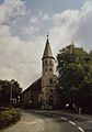
St. George's Church.

Bürgerhaus and Heinrich-Engelke-Halle


Personalities
- Clemens Schrader (1820–1875), Jesuit and theologian
Web links
Individual evidence
- ↑ Population of the city of Hildesheim as of December 31, 2019. In: hildesheim.de. Hildesheim Marketing GmbH, accessed on June 3, 2020 .
- ^ Federal Statistical Office (ed.): Historical municipality directory for the Federal Republic of Germany. Name, border and key number changes in municipalities, counties and administrative districts from May 27, 1970 to December 31, 1982 . W. Kohlhammer GmbH, Stuttgart and Mainz 1983, ISBN 3-17-003263-1 , p. 204 .
- ^ Local council of Itzum-Marienburg
City center and new town | Marienburger Höhe with Galgenberg | Moritzberg | North town with tax forest | East town
Achtum-Uppen | Bavenstedt | Drispenstedt | On one | Himmelsthür | Itzum - Marienburg | Neuhof / Hildesheim Forest / Marienrode | Ochtersum | Sorsum