
Maspalomas
| San Bartolomé de Tirajana municipality: Maspalomas | |||
|---|---|---|---|
 In the dunes of Maspalomas
|
|||
| coat of arms | Map of the Canary Islands | ||
 Help on coat of arms |
|
||
| Basic data | |||
| Autonomous Community : | Canary Islands | ||
| Province : | Las Palmas | ||
| Island: | Gran Canaria | ||
| Coordinates | 27 ° 44 ′ N , 15 ° 36 ′ W | ||
| Residents : | 123 (2011) INE | ||
| Postal code : | 35100 | ||
| Area code: | 35019002000 | ||

Maspalomas is an international resort in Gran Canaria . The place belongs to the municipality of San Bartolomé de Tirajana (Spain).
geography
Maspalomas is located on the southern tip of the Canary Island Gran Canaria , on the coast of the Atlantic . In the southeastern part, the place is separated from the sea by the dunes of Maspalomas. Maspalomas largely consists of holiday resorts and the associated infrastructure.
The place is divided into the following parts, which are delimited by gorges and thoroughfares:
- Pasito Blanco and El Hornillo: with a marina in the west of the town, separated from the rest of the town by a golf course, the place of residence of wealthier residents, e.g. B. Hotel managers
- Meloneras: south-western part, consisting of larger hotel complexes, shopping center and congress hall, built since 1997
- El Oasis: southernmost part by the Faro de Maspalomas lighthouse , consisting of some holiday complexes from the 1960s
- Sonnenland: northwestern part of Maspalomas, built on a ridge with smaller hotels and private residential complexes in the 1980s - larger hotels have been added since 1997
- El Tablero: northern part, already on the north side of the motorway, home of many hotel employees
- Campo International and Campo de Golf: in a wide gorge north of the dunes, southeast of Sonnenland, mostly consisting of bungalow complexes and a golf course, built between 1980 and 1995.
- Parque urbano del sur: In the gorge between Sonnenland and San Fernando, a city park has been created on an area of 0.6 hectares.
- Parque Tony Gallardo in Campo Internacional: Park with 4000 m², reopened after renovation in January 2020.
- Playa del Inglés : east of Campo International, built in the 1960s and 1970s.
- San Fernando de Maspalomas: north of Playa del Inglés, intended for employees, between the former GC-500 road and the motorway
- San Agustín : built in the early 1960s as the first beginning of the tourist complexes
- Playa del Águila: Settlement on a short beach east of San Agustín
- Bahía Feliz : northeast of Playa del Águila with private accommodation, apartment complexes and hotels
From Meloneras to San Agustín, a distance of ten kilometers, the various districts merge directly into one another.
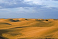
Maspalomas dunes

The dunes in the southeast of Maspalomas extend over a length of six and a width of one to two kilometers. The sand here does not consist of rock debris, but mainly of coral and shell limestone washed up and ground by the surf - sand from the Sahara blown through the Calima is not the actual origin. Heavy storms in spring 2006 and February 2010 did some damage and washed a lot of sand into the sea.
The only official nudist area in Gran Canaria is located in the dunes . At the lighthouse there is an oasis ("La Charca") where numerous water birds breed. Like the dunes, it has been a nature reserve since 1987 .
Economy and Transport
Maspalomas is shaped by tourism . The place has no other relevant industries. Near Montaña Blanca one located ground station ( English Mission Control Center ) of the Spanish space agency Instituto Nacional de Técnica Aeroespacial (INTA). There are many shopping malls and amusement parks. A special attraction is the Palmitos Park , about ten kilometers to the north , which suffered considerable damage during the devastating forest fires in the last days of July 2007 and was reopened on August 4, 2008.
Maspalomas is connected to Gran Canaria Airport and the island's capital Las Palmas de Gran Canaria as well as the west coast by the GC-1 motorway and bus lines .
The local transport network is well developed. During the day and within Maspalomas / Playa del Inglés, the modern buses of Global , known in the regional language "Guaguas", usually run every 20 minutes. The bus station at the lighthouse is an important hub .
climate
| Maspalomas | ||||||||||||||||||||||||||||||||||||||||||||||||
|---|---|---|---|---|---|---|---|---|---|---|---|---|---|---|---|---|---|---|---|---|---|---|---|---|---|---|---|---|---|---|---|---|---|---|---|---|---|---|---|---|---|---|---|---|---|---|---|---|
| Climate diagram | ||||||||||||||||||||||||||||||||||||||||||||||||
| ||||||||||||||||||||||||||||||||||||||||||||||||
|
Average monthly temperatures and rainfall for Maspalomas
Source: The climate in Maspalomas
|
|||||||||||||||||||||||||||||||||||||||||||||||||||||||||||||||||||||||||||||||||||||||||||||||||||||||||
history
Aboriginal people from the Canary Islands lived here from the 10th to the 15th century. The place has been repopulated since the 17th and 18th centuries. Maspalomas is the oldest resort on the south coast of Gran Canaria. The 68-meter-high El Faro lighthouse was built in 1889.

The tourist construction boom began in 1960. At that time, the large landowner Conde de la Vega Grande, whose La Elvira estate included large parts of the south of the island, decided to benefit from the growing mass tourism that was already flourishing on the mainland of Spain and the Balearic Islands . The upswing passed Gran Canaria by then, with the exception of the more traditional tourism in the big city of Las Palmas . At that time, the south of Gran Canaria was a barren, semi-desert and only sparsely populated area. Due to the development plan called Maspalomas Costa Canaria , however, construction began in October 1962, which changed the entire area forever.
After several times the dune area was reduced in size due to the growing development in earlier years and the expansion of the golf course and the Campo de Golf settlement , the dune area was placed under nature protection in 1987.
Site and development plan

For the southern tip of the island, the development plan provided for four settlement cores: initially three places called Playa del Inglés, mainly intended for holiday complexes, a little further east of it San Agustín and Maspalomas (today: Meloneras) further south-west by the old lighthouse. Another settlement is San Fernando, which adjoins Playa del Inglés immediately to the north and was primarily intended for Spaniards who would work in the holiday complexes to be built. Of these settlements, San Fernando is the only one that has at least a rudimentary historical core to show. A historic village or even old town center is not found here.
In Playa del Inglés in particular, despite various changes to the development plan, the differentiated design of individual streets and parts of the settlement can still be seen. Some streets (for example Avenida de Tirajana ) were specifically planned as shopping streets with many shops and multi-storey hotel developments. In between, and especially on the western and southeastern outskirts, there are several quarters in which a loose, heavily green building with gardens and free-standing bungalows in the Spanish style predominates. The quality of the overall impression was, however, reduced in later years by the fact that the number of floors was significantly increased for new hotels in the north of Playa del Inglés.
Nevertheless, Playa del Inglés still stands out positively from comparable Spanish mass tourism destinations such as Benidorm or Torremolinos due to its significantly lower building density and lower construction height.

Illustrations
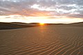
Maspalomas dunes in the morning sun

Tomorrow in the dunes
Maspalomas dunes in the diffuse sunrise light

Maspalomas dunes, view inland at sunrise

Maspalomas dunes during the day

Maspalomas dunes

Casino Maspalomas at night

lagoon

La Charca

El Faro lighthouse

View of the back of the beach of Playa del Inglés with the Anexo II promenade
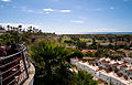
View from Playa del Inglés to Maspalomas (Campo Internacional and the golfers' village of Campo de Golf)

Lopesan Baobab Resort


Web links
Individual evidence
- ↑ Parque Urbano del Sur. Medio Ambiente - Parques y Jardines. In: www.maspalomas.com. Retrieved on March 1, 2016 (Spanish): "El Parque del sur es un parque urbano de 6,233 metros cuadrados de superficie."
- ^ Parque Tony Gallardo. In: parquetonygallardo.com. Retrieved April 12, 2020 (Spanish).
- ↑ Maspalomas: Historia de un pueblo. In: playademaspalomas.com. Retrieved March 1, 2016 (Spanish, m., Translation).