Millares (Potosí)
| Millares | ||
|---|---|---|
| Basic data | ||
| Residents (state) | 414 pop. (2012 census) | |
| height | 2308 m | |
| Post Code | 05-0301-0602-7001 | |
| Telephone code | (+591) | |
| Coordinates | 19 ° 26 ′ S , 65 ° 11 ′ W | |
|
|
||
| politics | ||
| Department | Potosí | |
| province | Province of Cornelio Saavedra | |
| climate | ||
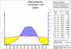
 Millares climate diagram |
||
Millares is a town in the Potosí department in the South American Andean state of Bolivia .
Location in the vicinity
Millares is the central place of the canton Millares in the district ( Bolivian : Municipio ) Betanzos in the province of Cornelio Saavedra . The village is located at an altitude of 2308 m on the eastern edge of the Bolivian Altiplano on the left bank of the Río Uchu Mayu. As early as the Inca times, an important thoroughfare from today's Potosí led past Millares in an easterly direction, and the cave paintings in the paleontological sites of Lajasmayu indicate an early settlement in pre-Inca times .
geography
Millares lies between the Bolivian plateau in the west and the Cordillera Central in the east. The climate of the region is a typical time of day climate , in which the temperature fluctuations during the day are greater than during the year.
The annual average temperature in the region is around 22 ° C (see Millares climate diagram), the monthly values fluctuate only slightly between 19 ° C in June / July and 24 ° C in November. The annual rainfall is a good 500 mm, the months April to October are arid with monthly values below 30 mm, only in January a rainfall of 100 mm is reached.
Transport network
Millares is 88 kilometers by road east of Potosí , the capital of the department.
The supraregional highway Ruta 5 runs through Millares, which leaves Ruta 7 , which runs north-south along the Cordillera Oriental , at La Palizada and heads south-west to the Chilean border. The Ruta 5 passes the cities of Aiquile , Sucre and Yotala , crosses the Río Pilcomayo and reaches Millares after a total of 354 kilometers. From here it leads via Betanzos , Potosí, Ticatica , Pulacayo and Uyuni for a further 544 kilometers to Chile.
population
The population of the village has increased by around two thirds in the past two decades:
| year | Residents | source |
|---|---|---|
| 1992 | 246 | census |
| 2001 | 360 | census |
| 2012 | 414 | census |
Individual evidence
- ^ INE - Instituto Nacional de Estadística Bolivia 1992
- ^ INE - Instituto Nacional de Estadística Bolivia 2001
- ↑ INE - Instituto Nacional de Estadística Bolivia 2012 ( Memento of the original from July 22, 2011 in the Internet Archive ) Info: The archive link has been inserted automatically and has not yet been checked. Please check the original and archive link according to the instructions and then remove this notice.
Web links
- Relief map of the Sucre region 1: 250,000 (PDF; 11.79 MB)
- Municipio Betanzos - General Maps No. 50301
- Municipio Betanzos - detailed map and population data (PDF; 735 kB) ( Spanish )
- Department Potosí - social data of the municipalities (PDF; 5.23 MB) ( Spanish )
