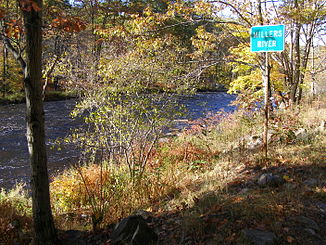
Millers River
| Millers River | ||
|
The Mohawk Trail along the Millers River near Erving |
||
| Data | ||
| Water code | US : 619274 | |
| location | Massachusetts (USA) | |
| River system | Connecticut River | |
| Drain over | Connecticut River → Atlantic Ocean | |
| source | in Worcester County at Ashburnham 42 ° 41 ′ 16 ″ N , 71 ° 57 ′ 18 ″ W |
|
| Source height | approx. 330 m | |
| muzzle | in Franklin County in the Connecticut River Coordinates: 42 ° 35 '50 " N , 72 ° 29' 48" W, 42 ° 35 '50 " N , 72 ° 29' 48" W. |
|
| Mouth height | 55 m | |
| Height difference | approx. 275 m | |
| Bottom slope | approx. 3.3 ‰ | |
| length | 83.8 km | |
| Catchment area | approx. 1000 km² | |
| Right tributaries | Tully River | |
| Reservoirs flowed through | Sunset Lake | |
| Communities | Athol , Erving , Millers Falls , Orange , Winchendon | |
Millers River is a 84 km long river in the northern part of the US state Massachusetts and a tributary of the Connecticut River .
The source is at Ashburnham , the confluence with the Connecticut River at French King Bridge near Erving . The catchment area of the Millers River covers 1000 km².
Millers River was formerly called ' Paquag ' or ' Baquag ', which means “clean, clear water” in the language of the Indian tribes of the Nipmuck .
Web links
Commons : Millers River - Collection of Pictures, Videos and Audio Files
Individual evidence
- ↑ Millers River in the United States Geological Survey's Geographic Names Information System
- ^ Nipmuc Place Names of New England, online at: www.nativetech.org/Nipmuc ...
