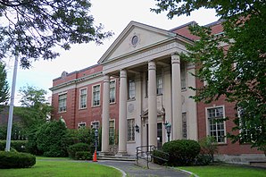
Franklin County, Massachusetts
 Franklin County Courthouse |
|
| administration | |
|---|---|
| US state : | Massachusetts |
| Administrative headquarters : | Greenfield |
| Foundation : | 1811 |
| Demographics | |
| Residents : | 71,372 (2010) |
| Population density : | 39.3 inhabitants / km 2 |
| geography | |
| Total area : | 1877 km² |
| Water surface : | 59 km² |
| map | |
The Franklin County is a county in the state of Massachusetts of the United States . The county seat is Greenfield . After the county government was abolished in 1997, the county only exists as a historical geographic region and serves some administrative purposes.
government
Like a slim majority of Massachusetts counties, Franklin County no longer has a county government. All previous functions of the county were taken over in 1997 by state authorities. The sheriff and a few other regional officials with special duties are still locally elected to serve within the county. The municipalities now have greater autonomy and can conclude regional contracts to offer services together.
geography
The county has an area of 1,877 square kilometers, of which 59 square kilometers are water. It is bordered in a clockwise direction by the following counties: Windham County, Vermont , Cheshire County, New Hampshire , Worcester County , Hampshire County, and Berkshire County .
history
Franklin County was formed in 1811 from parts of Hampshire County .
A place in Franklin County has the status of a National Historic Landmark , the Old Deerfield Historic District , due to its historical significance . 51 buildings and sites in the county are listed in the National Register of Historic Places (as of November 17, 2017).
Population development
| 1980 | 1990 | 2000 | 2010 |
|---|---|---|---|
| 64,333 | 70.092 | 71,535 | 71,372 |
Demographics
According to the 2000 census , Franklin County's population of 71,535 lived in 29,466 households and 18,416 families. The population was 95.40 percent white, 0.89 percent African American, 1.04 percent Asian, and 0.29 percent Native American. 1.99 percent of the population were Hispanic or Latino of any race. The per capita income was $ 20,672; 6.5 percent of families and 9.4 percent of the population lived below the poverty line .
cities and communes
Individual evidence
- ↑ GNIS-ID: 606932. Retrieved on February 22, 2011 (English).
- ^ Massachusetts Government: County Government ( English ) League of Women Voters of Massachusetts. Archived from the original on February 4, 2012. Retrieved on April 10, 2019.
- ↑ Listing of National Historic Landmarks by State: Massachusetts . National Park Service , accessed November 17, 2017.
- ↑ Search mask database in the National Register Information System. National Park Service , accessed November 17, 2017.
- ^ Franklin County, Massachusetts , 2000 census datasheet at factfinder.census.gov .
Web links
Coordinates: 42 ° 35 ′ N , 72 ° 35 ′ W

