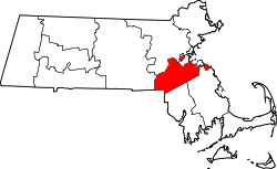
Norfolk County, Massachusetts
 Norfolk County Courthouse |
|
| administration | |
|---|---|
| US state : | Massachusetts |
| Administrative headquarters : | Dedham |
| Foundation : | 1793 |
| Made up from: | Suffolk County |
| Demographics | |
| Residents : | 670,850 (2010) |
| Population density : | 648.2 inhabitants / km 2 |
| geography | |
| Total area : | 1150 km² |
| Water surface : | 115 km² |
| map | |
| Website : www.norfolkcounty.org | |
The Norfolk County is a county in the state of Massachusetts of the United States . The county seat is Dedham .
geography
The county has an area of 1150 square kilometers, of which 115 square kilometers are water. It is bordered clockwise by the following counties: Middlesex County , Suffolk County , Plymouth County , Bristol County , Providence County (Rhode Island), and Worcester County .
history
Norfolk County was formed in 1793 from parts of Suffolk County .

There are two National Historic Sites in the county , the John Fitzgerald Kennedy National Historic Site , which is the birthplace of John F. Kennedy , and the Frederick Law Olmsted National Historic Site . There is also the Adams National Historical Park , which includes the birth houses of Presidents John Adams and John Quincy Adams . 14 sites have the status of a National Historic Landmark . A total of 341 structures and places in the county are registered in the National Register of Historic Places (as of November 17, 2017).
Population development
| 1980 | 1990 | 2000 | 2010 |
|---|---|---|---|
| 604.226 | 616.087 | 650.308 | 670,850 |
Demographics
According to the 2000 census , Norfolk County had a population of 650,308 in 248,827 households and 165,967 families. The population was 89.02 percent white , 3.18 percent African American , 5.50 percent Asian American, and 0.13 percent Pacific islander . 1.84 percent of the population were Hispanics or Latinos . The per capita income was $ 32,484; 2.9 percent of families and 4.6 percent of the population lived below the poverty line .
cities and communes
Web links
Individual evidence
- ↑ GNIS-ID: 606937. Retrieved on February 22, 2011 (English).
- ↑ Listing of National Historic Landmarks by State: Massachusetts . National Park Service , accessed November 17, 2017.
- ↑ Search mask database in the National Register Information System. National Park Service , accessed November 17, 2017.
- ^ Norfolk County, Massachusetts , 2000 census data sheet at factfinder.census.gov .
Coordinates: 42 ° 10 ′ N , 71 ° 11 ′ W
