Mohrenbach (Jossa)
| Mohrenbach | ||
|
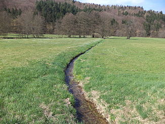
The Mohrenbach just before its mouth |
||
| Data | ||
| location |
Spessart
|
|
| River system | Rhine | |
| Drain over | Jossa → Sinn → Franconian Saale → Main → Rhine → North Sea | |
| source | in the gold fountain in the municipality-free area of Burgjoss 50 ° 13 ′ 30 ″ N , 9 ° 32 ′ 0 ″ E |
|
| Source height | 460 m above sea level NHN | |
| muzzle | between Burgjoss and Mernes in the Jossa Coordinates: 50 ° 13 ′ 7 ″ N , 9 ° 29 ′ 8 ″ E 50 ° 13 ′ 7 ″ N , 9 ° 29 ′ 8 ″ E |
|
| Mouth height | 290 m above sea level NHN | |
| Height difference | 170 m | |
| Bottom slope | 46 ‰ | |
| length | 3.7 km | |
| Catchment area | 6.5 km² | |
The Mohrenbach is a right tributary of the Jossa in the Spessart in the Main-Spessart district in Bavaria and in the Main-Kinzig district in Hesse .
geography
course

The Mohrenbach rises at an altitude of 460 m above sea level. NHN the Goldbrunnen , in the municipality-free area of Burgjoss west of Emmerichsthal in Bavaria.
It flows in a westerly direction, seeps there often and will not enter back into the community Obersinn belonging Mohr Bachwiesen to light. It then runs over the state border to Hesse and finally flows out at an altitude of 290 m above sea level. NHN between Burgjoss and Mernes from the right into the Jossa .
On its 3.7 km long path, the stream overcomes a height difference of around 170 m, which corresponds to a mean bed gradient of 46 ‰. The Mittelbühlgraben drains a 6.5 km catchment area via the Jossa, the Sinn , the Franconian Saale , the Main and the Rhine to the North Sea .
River system sense
See also
Web links
Individual evidence
- ↑ a b c Bavaria Atlas of the Bavarian State Government ( notes )
- ↑ a b Hessenviewer (Geoportal Hessen) of the Hessian State Office for Soil Management and Geoinformation with property mapping ( notes )
