
Penegal
| Penegal | ||
|---|---|---|
 Penegal from Lake Kaltern |
||
| height | 1737 m slm | |
| location | South Tyrol / Trentino , Italy | |
| Mountains | Mendelkamm , Nonsberg Group | |
| Dominance | 4.3 km → Bergner Kreuz | |
| Notch height | 246 m ↓ Furglauer Scharte | |
| Coordinates | 46 ° 26 '19 " N , 11 ° 13' 0" E | |
|
||

The Penegal ( Italian Monte Penegal , 1737 m ) is a mountain in the Mendelkamm in southern South Tyrol on the border with Trentino . A narrow and winding, toll-free road leads from the Mendel Pass over 3.9 kilometers with an altitude difference of 358 meters to the summit.
The Penegal is one of the most beautiful panoramic mountains in South Tyrol with a view of the Brenta Group in the southwest, the Ortler Alps in the west and the Dolomites in the east, as well as Bolzano and Kaltern with Lake Kaltern .
On the summit, which is divided between the municipalities of Ruffrè-Mendola , Sarnonico , Kaltern and Eppan , there is the Panorama Hotel Penegal and an associated observation tower (closed due to the dilapidation of the wooden staircase), as well as the Penegal transmitter on two side elevations .
The etymology of the name Penegal is unclear. In some Tyrolean dialects , Penegól (n) refers to the husks of the corn on the cob or the feathers on the corn stalks. Possibly the name of the mountain is derived from a comparison of the rocky outcrops and heads with the morphology of the maize plant, which was once often cultivated locally.
Picture gallery

Summit of Penegal from the road to Mendola Pass

Summit of Penegal, view of the Mendel ridge to the Roen
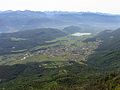
View of Kaltern and Lake Kaltern

View of Bozen , in front of it Eppan ( St. Michael , Girlan )


Web links
Individual evidence
- ↑ Johannes Ortner: Sassvaina and Türggstroh . In: Experience the mountains - The magazine of the Alpine Association of South Tyrol . No. 3 , 2019, p. 40-41 .